Tag Archives: dog

Boswell’s Books (Shelburne Falls, MA)

Date Visited: September 6, 2016

Location: 10 Bridge St, Shelburne Falls, MA

Hours:

Mon – Wed: 11:00 a.m. 6:00 p.m.

Thu & Fri : 10:00 a.m. – 7:00 p.m.

Sat: 10:00 a.m. – 7:00 p.m.

Sun:   10:00 a.m. – 6:00 p.m.

(hours may vary depending on the time of the year)

Parking:  There is unmetered  off street parking available (2 hour limit) and a free parking area off Baker Ave with about 30 -40 free spots (take care not to park in the spots reserved for businesses and other tenants in the area) and additional off street parking.  Parking is difficult during peak times

Dog Friendly: Probably Not

Web Site: Boswell’s Books


dsc_1021

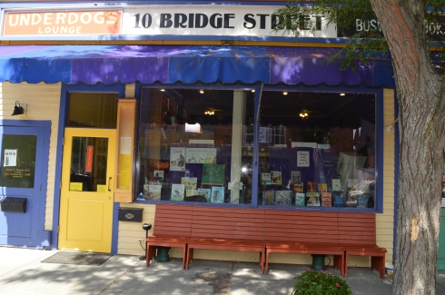
Few things go better than cats and books.  And Boswell’s Books is proof of this.

Formerly named the Bridge Street Bookshop until 1991, Boswell’s Books was originally named after one of the previous owners’ cats, Boswell.  Since then, the book store has gone through some changes, including changes in location and changes in ownership.  But, the one mainstay has been Boswell.

The current feline resident of the bookstore, a 7 year old female tuxedo cat, is the fifth Boswell.

We found her resting in the front window taking a much deserved cat nap.

dsc_1001

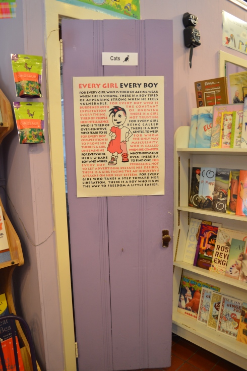
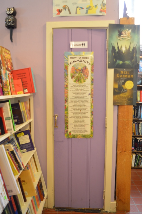
Boswell’s books has cute decor and, even though they may not be as big as some of the other bookstores, they make good use of the space they do have.

They even have acommodations for everyone, people and felines.

dsc_1009dsc_1007

Boswell’s also holds special events such as book signings and book readings.  It’s a must-see if you’re in the Shelburne Falls area!

There are so many fun places to visit in Shelburne Falls.  In fact, one need only to walk along Bridge Street to find some wonderful places to shop.  I have always found these smaller, independtly owned businesses to have  such friendly and great service. Plus, it’s always good to support locally owned businesses.

Mocha Maya’s Coffee House (47 Bridge St) is a cozy little coffee shop where you can bring your recently purchased book to read and have a coffee, sandwich or blended drink.  They also host musical events.

Unfortunately, the Trolley Stop Antiques and Collectibles shop was not open during our visit.  As you can see, the shop has some very unusual products.

Even if you don’t want to stop in at any of the shops or diners, Shelburne Falls is a great place to walk around and appreciate the views and the atmosphere.

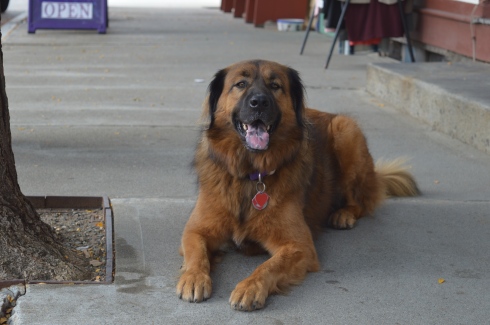
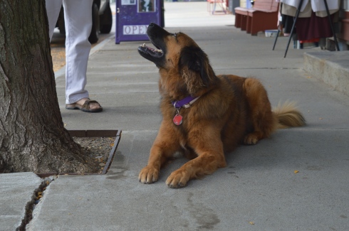
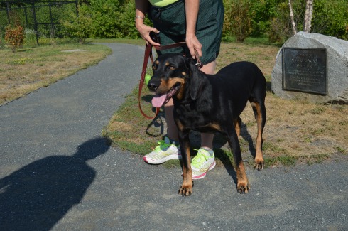
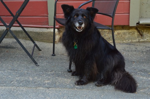
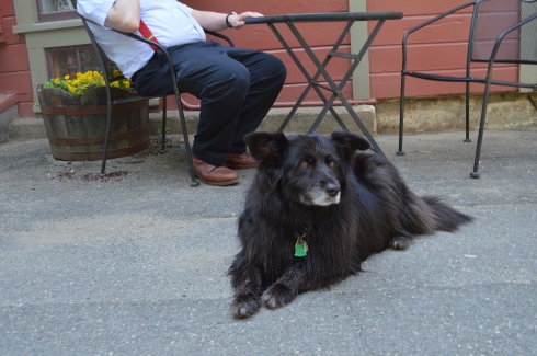
Boswell wasn’t the only pet I saw at Shelburne Falls.  Catfish (named after legendary New York Yankee pitcher Catfish Hunter) is a 4 year old (he will be turning 5 in November) Leonberger.  Leonberger’s are a large breed dog that were popular in Germany.  They were originally bred to be a symbolic dog that would mimic the lion in the town crest of Leonberg in Baden-Wurttemberg in Germany.  He’s truly a gentle giant.

dsc_1000dsc_0996


Bear Brook State Park (Allenstown, NH)

Date Visited: August 27, 2016

Location: 157 Deerfield Rd, Allenstown, NH

Cost: $4 for adults, $2 for children (ages 6-11), children 5 and under get in for free, NH residents 65 and older are also admitted free of charge

Hours: Open daily, sunrise to sunset, campground schedule: May 6 -Oct. 29 (2016), Sun-Thu 8 a.m. – 8 p.m., Fri 8 a.m. – 10 p.m.

Size: 10,000 acres

Time To Allot For Visit: 2 to 3 hours

Parking:  There are about 50-60 parking spaces in the main parking area (see photo below)

DSC_0640

Additional parking can be found at Hayes Field (see attached map)

Dog Friendly: Yes

Highlights: Very popular with cyclists, several large ponds and marshes, teeming with wildlife, campgrounds, archery target area, fishing (fly fishing only)

Lowlights: too big to hike or bike all in one day

Bear Brook State Park

Bear Brook State Park Trail Map


DSC_0502

A haven for cyclists and nature lovers, Bear Brook State Park in Allenstown, New Hampshire is the largest developed state park in New Hampshire.  Boasting 10,000 acres, over 40 miles of trails, several ponds and other bodies of water and marsh lands, Bear Brook is the biggest state park I have hiked.

Although there were many frogs and turtles visible at Bear Brook, birds, deer and other wildlife proved to be more elusive.

DSC_0259DSC_0294DSC_0311DSC_0299DSC_0360DSC_0393DSC_0560DSC_0418


DSC_0343

Bear Brook also has a fishing area, two of them actually.  There is the Archery Pond, which also has an archery target area.  Only fly fishing is allowed in the pond.

The archery target practice area is to the right of the pond.

Across the paved road from Archery is a kids fishing pond for children 12 years old and younger.  A fishing pond for children!  How cute is that?

What my visit to Bear Brook lacked in deer, birds and other more typically photographed wildlife, it made up for in smaller critters.

I did see a few runners and hikers but the overwhelming majority of the visitors at Bear Brook were cyclists.  The trails vary from flat and easy to steep, rocky and challenging.  I would consider some trails to be very challenging even for the advanced cyclist and I did not see any cyclists on some of the more steep and rocky trails.

You never know what you’ll find at Bear Brook State Park.  While walking along the main trail, I came across this grave site for an unknown soldier from the Civil War.  There is no marker for the Union or Confederacy.  The only flag or designation displayed is an American flag.

There is also a stream running under a bridge at the entrance

There are also several ponds, marshes and creeks.

There are also beautiful, vividly colored trees, plant life, spiderwebs (ok, maybe that’s not so beautiful) and a sign that summer is soon ending.

Speaking of beautiful trees and plants, one that thing is hate to see at parks is the cutting down of trees or, as the parks call it”sanitation timber harvest.”  However, in the case of Bear Brook, and most state parks, there was good reason for this sanitation.  Because of an infestation of red pine scale, many of the red pine plantations had to be cut down.  The sanitation began in 2013 and was completed in 2014.  For whatever reason, it’s always sort of sad to see so many open spaces and stumps.

The trail for Hayes Farm does not lead to a farm but rather what used to be a farm.  You can see remnants of the stones which surrounded the farm from the trail.

This is my only gripe about the park.  There are long swaths of land without much there.  It’s very pretty and largely untouched by humans.  In fact, it is such a big park that I was unable to get to one of the bigger attractions, Catamount Trail that is supposed to have pretty scenic views.  But, after 6 hours of hiking and photographing the park I didn’t have the energy for that hike.  But, keep it in mind if you do go.

There is also a campground with a place to park your camper or rent one of their own.  Check their website for fees and availability.

There were not many dogs at Bear Brook.  In fact, Jack, a 9 year old rat terrier from Rhode Island, is the only dog I saw during my trip.

DSC_0594DSC_0579DSC_0587

Similar Places I Have Visited In New England:

12345

Breakheart Reservation (Saugus, MA)

123456

Pawtuckaway State Park (Nottingham, NH)

Please Connect With me On Facebook:

Facebook


Scott Tower (Holyoke, MA)

Date Visited: July 30, 2016

Location: 8 Scott Tower Rd, Holyoke, MA, behind the Community Field Park at 51 Community Field Park, Holyoke, MA

Hours: Open everyday, no hours listed but it can be dangerous at night

Cost: Free

Parking: Roughly a couple of dozen parking spots are available at Community Field

Dog Friendly: Yes

Time To Allot For Visit: Between half and hour and an hour

Highlights: the tower, pretty views of West Springfield and the surrounding area, wildlife, plant life, easy mile hike

Lowlights: Graffiti all over the tower (all. over), a lot of broken bottles and other litter on the premises, some stairs to the top of the tower have holes in them or are missing, tower not accessible by car

Fun For One: Yes

DSC_0200

The walk to the tower is an easy mile walk with a few moderate inclines.  An easy way to locate the trail to Scott Tower is to look for the overpass.  Walk directly under the overpass and stay on the asphalt trail.  There are a lot of side trails and trees, plants, graffiti and remnants of what looks like used to be a waterfall or wall.  Now, the party days are way behind the Nomad but zig zags and 4:20?  Well, I guess things don’t change that much after all.  You crazy Holyoke kids.

Below is a side by side comparison of what the tower reportedly looked like in its heyday (July 16, 1972), a photo of what it looked like in May 31, 2004 and what it looks like now (July 30, 2016).  Yes, it’s pretty cringe worthy.

As a footnote, the tower was originally built in 1942.  Also, there used to be a fence around the tower which you can see at the bottom of the second photo taken in 2004.  The fence seemed to work as there is very little if any graffiti on the tower in the second photo.  Of course, the fence was torn down (presumably by visitors) and the graffiti and vandalism escalated.

There was also a lot of rustling in the brush from squirrels, chipmunks and other types of wildlife.  The vulture on the pole we saw on the way to the tower seemed like a bad harbinger.

Once the main attraction of Craft Hill at Anniversary Hill Park, Scott Tower is now a shell of what it once was.  Graffiti and litter cover the tower and it appears to be in disrepair.  In fact, you can see some remnants of what look like what used to be tables or shelters.  Even with all of the graffiti and litter, the tower is still impressive.

Not all of the graffiti was just messy chicken scratch.  Whenever I go to a landmark in MA, especially Western MA, there is bound to be some artistic renderings.  There wasn’t anything too artsy there but these images did catch my eye.


Scott Tower has two areas for observation.  There is an observation deck on the second floor and there is an enclosed area at the top of the tower.  The tower offers views of nearby Mount Tom and the Holyoke area.  The views are pretty sweet.  Just be careful if you  do go to the top.  Some of the stairs are missing or have holes in them.

It’s pretty far down from the second floor of the tower.

DSC_0083

The tricky thing about accessing Scott Tower is you have to park at Community Field Park (use the entrance off Cherry St).  The entrance is behind the park.  There is usually a gate up that you can easily navigate around.  You will have to pass under an overpass on your way to the tower.  It is about a mile walk to the tower.  You will see many side trails on your way to the tower but stay on the main trail for the easiest, most direct route.

While I was at Community Field Park before we began the walk to Scott Tower, we saw this beautiful dog.  Remy is a 4 year old Black and Tan Coonhound

DSC_0019DSC_0036DSC_0035

Below are some videos of a walking tour of the tower.  I really had to watch my step in the first video.  So, it’s mostly a video of the stairs and me wheezing.

I had to stop the second video so I could take some photos of the openings in the tower and the walls.

Just as an aside, I am regularly updating my categories at the top and bottom of my posts.  The “fun for one” category at the top simply means it can be fun to do by yourself.  Being a single person, I often take this into account before I decide to photograph or visit places.  I went with my mom this time so it was a lot of fun but it was something you could do by yourself or, better yet, with a dog!

Similar places in New England I have visited:

poets1


Poet’s Tower, Greenfield, MA

bancroft

Bancroft Tower, Worcester, MA

Similar places in New England I have not visited (yet):

scargo

Scargo Tower, Dennis (Cape Cod), MA

newport

Newport Tower, Newport, Rhode Island


Moswetuset Hummock (Quincy, MA)

Date Visited: April 21, 2016 & May 22, 2016

Location: East Squantum St, Squantum (Quincy), MA

Cost: Free

Parking: about 8 parking spots.  Parking is also available at the beach which is located about half a mile away on Quincy Shore Drive and is an easy walk to Moswetuset.

Highlights: great views, easy trail, secluded, not usually very busy, a lot of historical significance

Mosewtuset may seem much like all the other small parks that dot the Massachusetts shoreline.  But, its significance in the historical landscape of Massachusetts and all of the colonies and commonwealths should never be minimized.

Moswetuset is not only significant because the commonwealth of Massachusetts derived its name from Moswetuset but it is also the original trading place of Chickatawbot Sacamore and Myles Standish in 1621 that spurred the trade of the early settlers and the Native Americans. Moswetuset was also the area they used as their planting grounds.

What does a funky name like Moswetuset mean, you may ask.  Moswetuset has been translated into “shaped like an arrowhead” (the area does have a distinct arrowhead shape) and “site of the great house.”  The area is shielded by rows of trees and growth.

DSC_0090

The trail is an easy loop with a very minor incline.

Only underscoring how small things can be very big in their place in history, Moswetuset is only a quarter of a mile loop, if that.  But, it does offer some pretty views and it is a nice place to take a short stroll or sit on one of the many rocks along the beach (Moswetuset is located next to Wollaston Beach).  It was low tide when I went so I was able to get out onto the rocks and get some decent views of the water and the surrounding neighborhood of Squantum (which is technically part of Quincy) which is in the background of the photos.

This slideshow requires JavaScript.

Of course, what would a park or attraction in Quincy be without graffiti? There were some interesting works of graffiti at Moswetuset.

Moswetuset is a popular place for dog walkers.  But, for some reason, there weren’t any dog walkers at Moswetuset when I visited.  I found Buddy, though, on my way to my car as I walked along the beach.

DSC_0040

DSC_0037


Montague Bookmill (Montague, MA)

Date Visited: March 28, 2016

Location: 440 Greenfield Rd, Montague, MA

Hours: Mon-Wed 10 a.m. -6 p.m., Thu-Sun 10 a.m. 8:00 p.m.

Parking:  there is lots of parking on the side and back of the book store.  There is also a lot across the street from the bookstore.

Montague Book Mill

DSC_0398DSC_0353

Do you like books?  How about mills?  Then I have just the place for you.  But, this is no ordinary book store.  A former gristmill now operating as a used book store, the Bookmill has gone through many changes throughout its history.  But, it still keeps true to its beginnings.  The structure is largely the very same one that operated as a mill so long ago and the brook that runs along the two floor book shop is the very same one they used to power the gristmill so long ago.

Upon arriving at the Bookmill, the first thing you notice is the brook fed by a waterfall adjacent to the shop.

A short easy to walk path takes you to the source of the stream of water.

DSC_0157

The short waterfall and stream can be pretty fast in some spots.  But, when I came to visit it slowed down after it plummeted down the waterfall.

This slideshow requires JavaScript.

After the short walk back up the trail, you can access the bookstore by a wooden walkway with some more views of the waterfall and stream.

Or, you can just walk straight across (the easier route, less scenic route).

The great thing about the Bookmill is that it has kept much of the original charm and design of the past.  Narrow stairwells and cozy corners are the hallmark of the shop.  Memorabilia, such as old style typewriters, are scattered throughout the store.  The staff doesn’t rush you nor do you feel a sense that profit is their main driver.  Service and a respect for books seems to be the most important thing t the staff.  It’s a great place for any book lover and anyone who loves to lounge around historic places.

This slideshow requires JavaScript.

They even have newspaper clippings and memorabilia along the walls in the more private areas.

The Bookmill is not the only shop in the area.  In the shopping area there is also a cafe, The Lady Killigrew Cafe, located next to the book store and The Alvah Stone, a restaurant. There are also two art studios and an entertainment/media store called Turn It Up.  Turn It Up specializes in selling cd’s, dvd’s, vinyl and even cassette tapes.  They also sell other memorabilia.  It’s a unique store in a very unique shopping area.

The owner of Turn It Up let me photograph his 10 year old  dog and part owner, Daisy.

DSC_0363DSC_0355DSC_0357

Below is a video of the waterfall and stream next to the Bookmill.

Please stop by and connect with me on my Facebook page: New England Nomad


Wilcox Park (Westerly, RI)

Date Visited: April 30, 2016

Location: 44 Broad St, Westerly, RI

Cost: Free

Hours: Open from dawn to 9 p.m., 365 days a year

Parking:  There is not a designated parking lot for Wilcox Park.  But, you should be able to find off street parking.

DSC_0226

Wilcox Park is not your average park.  In fact,  it is unique in many different ways.  One thing that makes Wilcox Park unique is that it is not part of the DCR or any other city or governmental body.  Wilcox Park is privately operated by the Westerly Public Library’s Board of Trustees.  The library, located on the grounds of the park, and a group of volunteers help keep the grounds clean and orderly.  They rely on donations and fundraisers.

Westerly Library is attached to the park at the entrance.  The library’s beautiful architecture of the building is both artful yet modest.  It complements the beauty of the park and seems right in place.  There are also benches for visitors to unwind and perhaps read a book from the library’s collection.

There are also a number of statues in the grounds of the library.


As you entered the park, one of the first statues you will see is the statue of Christopher Columbus sculpted by Ciriaco (or “Charles” as he was commonly known as) Pizzano in 1949.  Originally from Avellino, Italy, Pizzano was living in Medford, Massachusetts, when he decided to sculpt this statue, appropriately, out of Westerly granite.

DSC_0230DSC_0239DSC_0238


The inscription reads:


CRISTOFORO COLOMBO
INTREPID ITALIAN EXPLORER
WHO LINKED THE OLD WORLD OF
OUR FATHERS TO THE NEW WORLD
OF OUR SONS

On the back of the pedestal:

DEDICATED
BY
THE CITIZENS
OF
WESTERLY AND PAWCATUCK
A.D. 1949

Somewhere Leif Erikson is rolling around in his grave.

Down the staircase from the entrance to the park is a fountain (which was not running when I went to visit due to the still cold temperatures).  The Wilcox Memorial Fountain was designed by John Francis Paramino in 1898 and was dedicated in honor of Harriet and Stephen Wilcox who had donated the land for the park.

There are a variety of beautiful trees, plants, bridges and statues at Wilcox Park.

This slideshow requires JavaScript.

There is also a pond along the trails at Wilcox Park.  It is populated with Koi fish

DSC_0323

ducks

DSC_0303DSC_0296

There’s room for two on this thing, right?

DSC_0310

and baby turtles.  I couldn’t find his mommy but I am sure she was nearby.

DSC_0411DSC_0410

and rabbits

The bronze Runaway Bunny statue was dedicated in 1998 by Connecticut sculptor Joan Binney Ross.  it is based on the book of the same name by Margaret Wise Brown.  Unfortunately, the bunny has been the target of vandalism, predictably.  But, it has been restored after each attack.  Cameras are now installed liberally around the park to deter vandalism or catch the vandals.

This fella just wanted to play with the ducks

DSC_0404DSC_0405

This sculpture sort of looked like a face to me.  A very ugly face.

DSC_0388

Dogs are allowed at Wilcox Park.  Bandit, a Siberian Husky, had fun playing in the park.  Apparently, Bandit earned his nickname because he “takes things”.  What a beautiful dog.  He caught my eye because of his handsome markings and his very cute smile. You can tell he’s a “bandit” based on his playful grin.

DSC_0352DSC_0353


Wadsworth Falls State Park (Middletown, CT)

Date Visited: May 7, 2016

Location: 701 Wadsworth St, Middletown, CT or Cherry Hill Rd, Middlefield, CT

Cost:   When I went to visit, it was free.  I think they begin charging a fee starting Memorial Day weekend.  There is no fee entrance fee during the weekdays.  It costs CT residents $9 and it costs non Connecticut residents $15 to get in to the park during the weekend.  You also may be able to access the park for free at the Cherry Hill Rd entrance.

Hours: Open everyday from sunrise until night time.

Parking:  There are about 30 parking spots at the main entrance at Wadsworth St and another 20 or so at the Cherry Hill Rd entrance in Middlefield (pictured below)

DSC_0531

We entered at the main entrance on Wadsworth St.  There is a sandy beach area (there is a lifeguard on duty during the summer season).  Since it was an overcast and chilly day, there weren’t any people swimming but there were a lot of birds congregating near the water.

The highlight of the park, of course, are the falls.  The two waterfalls at Wadsworth Falls are creatively named “Little Falls” and “Big Falls.”

DSC_0464

Once you get on the main trail, you will eventually see the sign for the falls (after about a 3/4 to one mile hike).  From this sign, it is about a half mile hike to the Little Falls and a mile hike to Big Falls  if you enter from the entrance on Wadsworth St.  There are also lots of trails that branched off the main trail and would be fun to explore if you have the time.

You can avoid the longer hike by parking on Cherry Hill Rd.  Big Falls is accessible from a short walk down a well defined path from the lot on Cherry Hill Rd.  But, the parking lot at Cherry Hill Rd is smaller than the lot on Wadsworth St.

Little Falls is actually a pretty big fall, even if it isn’t the biggest one at the park.  But, the height of this waterfall may actually surpass the height of Big Falls.  The last few shots in the slideshow are from our trek back to the main parking lot.  The falls seemed much less rapid on our way back and you can see the ledges of the falls better.

This slideshow requires JavaScript.

There are a few different ways to get to Big Falls, the main attraction.  The safest, but longest way, is to follow the trail until you reach the edge of the park which filters onto Cherry Hill Rd.  The park is a short walk on a sidewalk to the right.  Or, you can cross the railroad tracks and follow trail along the tracks for quicker access.  There really isn’t a defined trail but there is space to walk a safe distance from the tracks.  The railroad is still in operation but we didn’t see any trains while we were there.

There are two places I photographed the waterfalls from but there are probably even more places to view the waterfalls.  The first place is a little tricky to get to and potentially dangerous.  There is a path that goes off the trail across the tracks and up to ta cliff that offers some decent views of the waterfall.  I did take some photographs from there but I would bypass it and go to the parking area of the entrance on Cherry Hill Rd to get a safer, closer and less obstructed view of the waterfalls.  The first two photos are from the cliff area the rest are views from the entrance to the park.

This slideshow requires JavaScript.

From the main entrance on Wadsworth St it is about 1.5 mile hike to the falls and it is a 3.4 mile trail loop to walk the entire park.  There were bicyclists, walkers and other photographers along the trail.  Because of the inclines and, in some areas, rocky terrain, it would be a challenging place to go for a run.  I would describe the trails as being easy to slightly moderate because of the inclines and rocky trails.

There are also pretty trees, bridges, plants, brooks and streams along the trails.

This slideshow requires JavaScript.

There was a lot of bird activity at Wadsworth Falls such as this male red-winged blackbird.

DSC_0321

There are a variety of bird life at Wadsworth including bats.  This is a bat house.  It was built and maintained as part of an Eagle Scout project to help restore the bat population.  It was good to see that it’s not only the cute animals that are being helped.

Toads and other amphibious life is also abundant at Wadsworth State Park.  It was still pretty cold out so these toads seemed out of sorts.  We gently picked them up and tried to find a warmer place for them under some leaves.

Leashed dogs are allowed at Wadsworth State Park.  It is a great place for dogs to play and roam around.   Caesaris (pronounced Kay-sar-is), a friendly 1 year old female Labrador and Australian Sheep Dog, enjoyed the unseasonably cool weather with his mom.

DSC_0467

DSC_0466

Below are some videos I took of the falls.  The power, crispness and sound is much more evident in the videos.


Watch Hill Lighthouse (Westerly, RI)

DSC_0596

Date Visited: April 30, 2016

Location: Lighthouse Rd, Westerly, RI

Cost: Free

Parking: Vehicles are not allowed on Lighthouse Rd, unless you area senior citizen or if you have a physical impairment which may prevent you from walking or biking or running down.

The jewel of Westerly, Rhode island, Watch Hill Lighthouse is a stone’s throw away from Napatree Conservation Point.  The walk down Lighthouse Rd is about half a mile and the views are worth the walk.  Watch Hill is a swanky village in the town of Westerly that offers views of the southern most coast of the state (besides Block Island).

To get a sense of just how beautiful the area is, this is the view from someone’s driveway.  Not a bad view to wake up to every morning.

There are more stunning views as you walk down the road.

This slideshow requires JavaScript.

There is also a “cliff walk” along the road which is basically a walkway along the sidewalk which allows you to walk on a “cliff” type access way next to the road.  Besides being a fun way to travel, the cliff walk also offers some beautiful views.

Since it is somewhat isolated and not too active this time of the year, birds tend to congregate at Watch Hill.  I found a few Double Crested Cormorants.

Watch Hill Lighthouse is the second oldest lighthouse in Rhode Island (Beavertail Light is the oldest lighthouse in RI).  Originally built in 1808, Watch Hill Lighthouse has been destroyed or damaged by various storms over the years.  The current lighthouse that stands there was built in 1856.  It was automated in 1986 and it is still active today.

DSC_0646DSC_0645

The best part of my trip to Watch Hill was watching the waves from the rocks.  It is considered one of the more beautiful and romantic of Rhode Island (sans Newport).  In fact, just before I arrived there I had missed a man proposing to a woman at the location.  When I got there they were drinking champagne and cuddling as they watched the waves.

This slideshow requires JavaScript.

Cute little Louis (pronounced Louie) is a 3 year old toy poodle.  I love how the wind blew his fur and ears back but he still wanted to see the lighthouse!

DSC_0649DSC_0648

Below are two videos of the waves at Watch Hill to give a better sense of the power of the waves there (and this was just on a regular day)

Please connect with me and like my Facebook page to see extra photos and videos I don’t post on my blog!

New England Nomad


Wiggly Bridge (York, ME)

Date Visited: April 23, 2016

Location: Lilac Lane, York, ME

Cost: Free

Hours: Open 24 hours a day, 365 days a year.

Parking: There are about a half dozen parking spots on the side of the road across from the bridge on Lilac Lane (a very busy road so be careful parking and crossing there).  There is also additional parking on side streets and farther along the road on Lilac Lane.


There are many bridges in New England.  But, only few have the name, reputation and appearance of a bridge that could collapse any moment.  The Wiggly Bridge is a mini-suspension bridge built in the 1930’s which crosses over a tidal flow from Barrel Mill Pond to the York River.  If you’re not careful, you may end up in the York River!

Ok, Wiggly Bridge really isn’t that dangerous.  But, it can give you the willies as you walk across it.  Even though it is safe to walk across, the bridge does wiggle and make noises as you traverse it. I made it across the bridge without much trouble and took some photos of the bridge as I made my way across.

The short walk across the bridge leads to Steedman Woods, a tiny peninsula with a mile long loop.  Dogs are allowed on the beach and on Steedman Woods.  The vieews from the island and bridge are stunning.

This slideshow requires JavaScript.

Wiggly Bridge is also within walking distance, or a short drive from York Harbor.  So, you can take in both of these cool attractions in one day.

Cooper is a 7 year old rescue dog and a resident of Maine.  He also likes the bridge.

The videos below shows how unstable the bridge seems when you’re walking on it.

Please connect with me on Facebook here


Westfield River Whitewater Races (Huntington, MA)

Date Of Event: April 16, 2016

Location: Knightville Dam, Huntington, MA

DSC_0373

Each year hundreds of kayak and canoe racers come to the Western Massachusetts to test their mettle against the rapids of the Westfield River.

The Westfield River, one of the longer rivers in Western Massachusetts, runs 78.1 miles and has a 497 square miles drainage area consisting of several tributaries.  It attracts enthusiasts, recreational competitors and people who just like to challenge themselves.  It also attracts an array of boating fans.

The Westfield River Whitewater Races, which have been held every year since 1953, are the oldest consecutively run canoe races in the US.  People come from all over New England and farther to participate in the races.  The races consist of novice and expert divisions.  The novices race lasts 8 miles and the experts race for 12 miles.  The participants race in two person canoes or one person kayaks. As if the rapids weren’t challenging enough, the race officials have the water behind the dam held for three days before the race to give more momentum to the current.

I never knew how popular kayaking, canoeing and boating was in Western Massachusetts.  It was hard enough to find a good place to pull over or park along the route of the race.   I was able to find a place on the side of the road to catch some of the novices who had already started.

Since the river wasn’t very active here, we drove to the Knightville Dam, the launch point for the race.  The area was very pretty and the river was more active here.  I even caught some enthusiasts who weren’t participating in the race.

DSC_0252DSC_0263DSC_0272DSC_0250


At the main parking area, one of the racers let me photograph his boat.

Still not happy with my location, I found a better spot along the side of the river past a precarious rocky decline.  Watching the racers expressions was fascinating.  Some were determined.  Others looked focused and even a bit bewildered.  Others just looked like they were having a grand time.  Then, there were others who didn’t seem to be having fun at all.

This slideshow requires JavaScript.

Not every racer made it to the end.

Eventually, they were able to wade across the river to the other side, no easy task given the strength of the rapids.

Monty, an 8 year old Siberian Husky, came along to watch the race.

Below is a video of a canoe racing tandem fighting the rapids.  You can hear the strength of the tide.  Rumor has it that it gets even rougher farther down the river.

Please stop by my Facebook page, say hi and like it: New England Nomad On Facebook