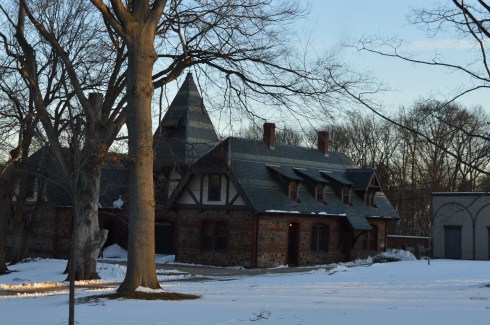
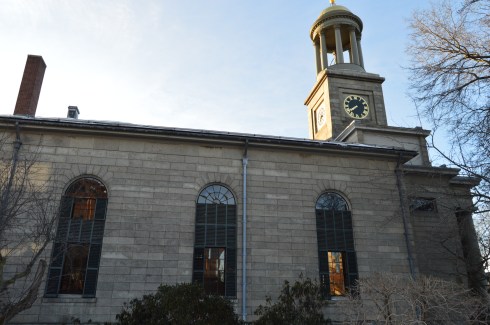
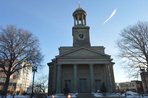
Location: Salem, Commons, Washington Square, Salem, MA
Universally Accessible: Yes
Dog Friendly: Yes
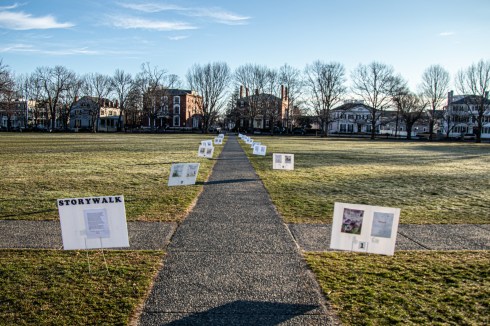
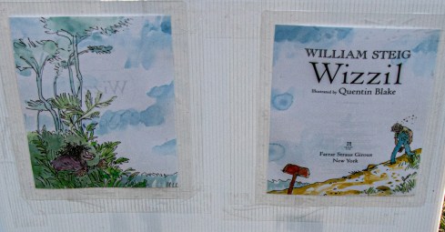
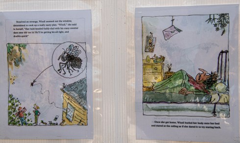
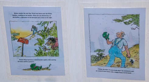
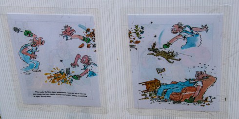
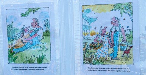
Summary, 18 placards tell the story of Wizzil, a horrible hag who wants to add some excitement to her life. Without giving away too many spoilers, her parrot suggests she amuse herself by making someone else suffer. Hilarity ensues.
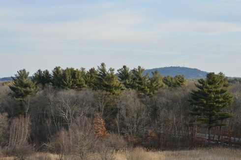
It definitely seems like this whole “socially distancing” thing is working. During my quick, socially distanced visit to Salem, MA, there was hardly a soul in the area. In fact, many people were probably curled up with a book.
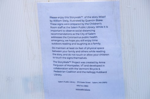
Salem Public Library has brought the best of both worlds to the Salem Commons. The Storywalk, which was based on the children’s book Wizzil by William Steig and illustrated by Quentin Blake, was created so that families could enjoy the outdoors while still reading and laughing as a family.
The 18 signs are placed within the socially distanced spaces recommended by the government. They were prepared by the Children’s Room staff at the Salem Public Library.
If you do go, there are some ground rules. First, you must give each visitor a 6 foot zone of space for social distancing purposes. Visitors are also discouraged from touching the signs.
You can read the story below. I have I have posted the photos of the placards in the order of how they were placed at the common. You may have to expand the screen to read the lettering since it is so small. Or, better yet, go to the Commons and read it for yourself!
Below are some photos of Salem Saturday morning. It was very desolate and I was half expecting a zombie or some other undead being to come around one of the corners. I was in Salem after all. It was just me and this very hungry squirrel.
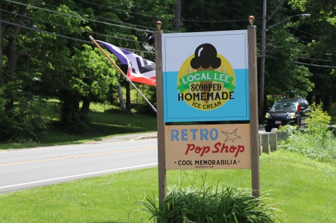
Are you looking to relive old memories and go back to an easier, simpler time? While it’s not literally possible to go back in time, Pop’s Retro Shop can make you feel as though you’ve gone back in time, or that you’re living in your parent’s hey day. Odds and ends older than many of you reading this post are scattered throughout this vintage shop in Lee, MA.
Coke and McDonald’s memorabilia take up much of the space at the Retro Pop Shop. In fact, Ronald is there to greet you when you walk in the front door.
Old coke bottles, lobsters, Simpson dolls and toy trucks lie scattered around the shop. Walking around the store was much like walking around my childhood room (or present day apartment).
Vending machines, refrigerators and even old gas station filling tanks are stored inthe garage of the shop.
Just walking past the old lunch boxes and lava lamps brought back so many memories and happy thoughts.
But, be aware. There are lots of creepy statues, dolls and other items that seem more suited for Halloween. Of course, it only made me like the store all that much more.
Retro Pop Shop is truly a family run business. While Pierre runs the store, his daughter owns and operates the Local Lee Homemade ice cream store attached to the Retro Pop Store.
Keeping with the decor of the inside of the shop, the outside of the store has some vintage and offbeat items lying around. They must get some pretty big rats out in western MA based on the trap by the entrance.
Although dogs are not allowed in the store (Pierre said a customer had complained about dogs being in the shop in th past), they are welcome on the grounds outside. I spotted this cute Samoyed in front of the shop.
Today’s featured site is a website for a store that is very similar to retro Pop Shop. While walking through the Retro Pop Shop, I couldn’t help but think of another store in New England that caters to the fans of vintage memorabilia. But, Wild Bill’s Nostalgia hs so much more .
Trails:
Tues-Sun, & Mon holidays, dawn to dusk
Closed Mondays
Cost:
(MA Audubon) Members: Free
Nonmembers:
$5 Adults
$4 Children (2-12)
$4 Seniors (65+)
Parking: There are about 50 0r so parking spaces in the parking lot
Trail Difficulty: Easy to moderate
Size: 9 miles of trails
Time To Allot For Visit: 2 to 3 hours
Highlights: abundant wildlife, clearly defined trails, lookouts and bridges, several pond areas
Lowlights: One of the ponds (Little Farm Pond) is only accessible via motor vehicle and is not accessible from the sanctuary, according to one of the staff workers at the sanctuary
From the moment I drove into the parking lot for Broadmoor Wildlife Sanctuary (a MASS Audubon sanctuary), I could tell it was going to be a special place. The pretty trees and stocks of grass reminded me of some rural, country farm.
The 10 trails at Broadmoor are fairly easy to negotiate (the Charles River Loop is probably the most challenging). There are a few trails that cross over ponds and marsh land.
Overall, the trails are easy with a few moderately difficult trails such as The Charles River Loop. The trail on the Charles River Loop is somewhat narrow in some places and it can be hard to follow the trail (look for the yellow and blue marked trees).
There was a lot of activity, such as turtles, in the ponds. Can you spot the turtles in this photo? There are three.
What if I get closer?
How about now?
Broadmoor is teeming with wildlife. I found these critters during my hike.
There is also a lookout area where you can sit and look out upon the pond where I found this heron hiding.
There is a lot to see at Broadmoor. There are lots of turtles, butterflies, birds and evidence of other wildlife.
I found this beautiful swan as I was walking along the park.
All that swimming and looking for food can make you tired. So, she decided to take a nap.
There are also beautiful views of the park. The flowers, plants and trees make for a beautiful backdrop.
Broadmoor Wildlife Sanctuary is the perfect visitors of all ages (I even saw some visitors in strollers). It can be buggy but, as lucky would have it, that won’t be a problem for much longer in New England as fall descends upon us.
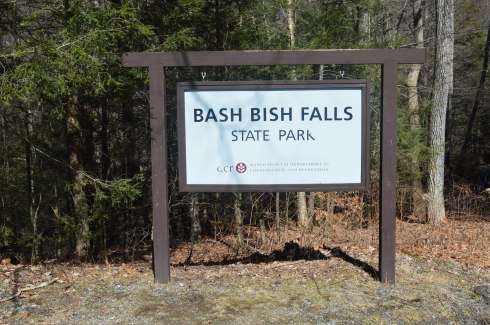
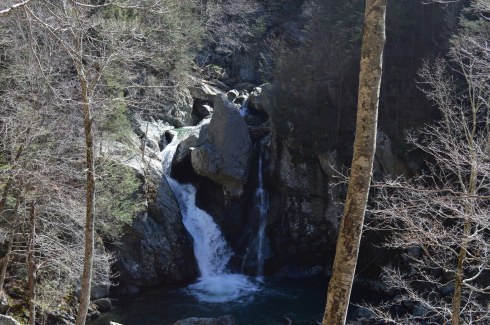
Located in the most southwestern part of Massachusetts, Bash Bish Falls is considered one of the most dangerous waterfalls in not only Massachusetts but the entire United States. It is also one of the most beautiful.
According to legend, Bash Bish was the name of a Mohican Native American woman who was accused of adultery which was punishable by death.. Bash Bish was pushed over the falls while tied up in a canoe.
The shape of the falls is said to resemble a woman falling to her death. Another theory claims the segmented characteristic of the falls resembled the reuniting of Bash Bish and her daughter White Swan who had also disappeared over the falls according to the Mohican legend. If the rapids of the stream leading from the waterfall and the speed of the water falling from the waterfall are any indication, the restless spirits may still be there. It is also a good reason why swimming is not allowed as the rapids can be very strong and it is easy to hit a rock.
This slideshow requires JavaScript.
Bash Bish Falls is located in Massachusetts, just past New York/Massachusetts border.
There are several entrances for Bash Bish. One of the entrances, at the top of the hill from the Massachusetts entrance on Falls Rd, gives ample evidence as to why Bash Bish may be considered such a dangerous waterfall. The stairs, which are a generous description, and walkway, also a generous description, are rocky and treacherous. There is a railing to hold on to. But, it’s still a tricky path.
I would recommend using the first parking spot on Falls Rd, if you’re traveling from Massachusetts. The trails are easy to moderate with a few slight inclines from the first parking lot. It is a 3/4 mile walk to the waterfall from the parking area.
There are many interesting rock formations along the trail. Little known factoid: I learned a new word recently for the strange piles of rocks stacked creatively that we often see along trails and at beaches like the rocks in the first two photos in the top row of photos below. They are called cairns, unless you ask a conservationist or geologist in which case they will condescendingly call them just rock piles since real cairns are nature made and not man made.
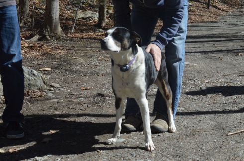
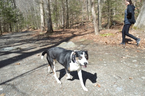
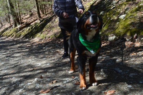
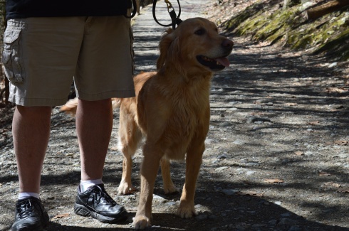
Bash Bish Falls is a popular spot for dog walkers. I met the following dogs during my hike.
Charlie
Juno, a Rottweiler and Shepherd mix
Cassie, a Bernese Mountain Dog.
Murphy, a beautiful Golden retriever
To get a better perspective of the waterfall and the stream leading from the waterfall, I have attached the following videos.
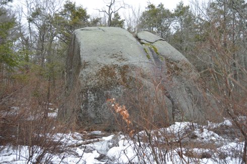
People travel far and wide to Agassiz Rock (pronounced “A-ga-siz”)to visit a rock. Yes, a rock.
Actually, they travel to see rocks. Lots of them.
Agassiz Rock is a deceiving name. There are actually two main rock structures that are the highlights of the park creatively named “Big Agassiz” and “Little Agassiz.”
The trail is not difficult. At least it’s not too bad when there’s not ice and snow on the ground. There are a few sharp inclines but mostly it is a fairly easy trail.
This slideshow requires JavaScript.
Along the trail, there are many eye catching rocks and streams.
The trails are clearly marked and signs point to the two rocks.
Left to “Big Agassiz.” Stay straight on the trail to get to “Little Agassiz.” The trail about a 2 mile loop. So, you can see both rock locations if you take the trail in its entirety which is what I did.
Big Agassiz is only a quarter mile or so from the sign.
Yup, that’s “Big Agassiz” it all its glory.
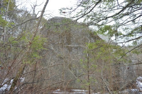
A trail leads to “Little Agassiz.” Ironically, the “Little Agassiz” is the better part of the attraction.
Along the way, I had a feeling I wasn’t alone based on the paw prints or hoof prints I saw in the snow. I quickly made my way up to “Little Agassiz.”
A short hike that includes one of the few inclines leads to the top of the Beaverdam Hill where “Little Agassiz” is.
There are several rock formations, trees and a area to just sit and chill. If I brought a book I would have been right at home. I could have stayed all day. But, I was a little disappointed in the views or lack thereof. There are mountains or other wonders of nature to look at. You do get a nice view of the roadway, though. Just a few tips: it can get pretty windy up there and if you do go in the morning during the winter be aware the rocks and the surfaces can be slippery.
This slideshow requires JavaScript.
You get a pretty good view from on top of the rocks.
I found one more rock formation of notice on my way out.
The parking area for Agassiz Rock is off a busy roadway and while I didn’t have any problems finding a spot I think it would be a little tough during the summer. There is probably room for a dozen or so cars if people park normally.
Below is a video of Little Agassiz.
Please connect with me on Facebook for additional photos and videos at New England Nomad
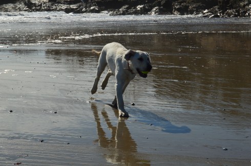
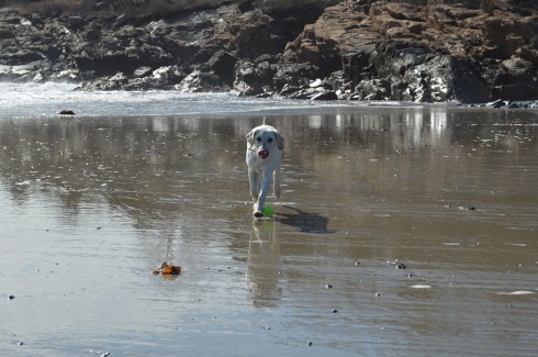
A hidden gem of the Coolidge Reservation, Magnolia Beach is located a short walk from the main entrance (about a half mile walk). From Coolidge Reservation, just take a left by the bridge off the main trail and you’ll find this sandy paradise. Or, you can access the beach more directly from a lot at the main entrance in the nearby city of Gloucester. Magnolia Beach is a fairly small beach so if you do plan on going, I would plan on getting there early as it must get packed during the summer days.
It was the perfect day for a walk along the beach – low tide, 50 degree weather and the waves were swelling.
This slideshow requires JavaScript.
Magnolia Beach is a perfect for dogs and humans. Gigi had fun playing catch.
The sea shells on the beach are very unique.
This house on the hill above the beach must have some great views.
One of the beach goers took advantage of the windy conditions to fly his or her kite.
Attached below is a video of the sights and sounds of the beach during my visit.
Parking: there is a parking lot located next to the memorial with over a dozen or so parking spaces. There are also parking lots and off street parking nearby.
Although she is known more for her success as a teacher and most notably working with Hellen Keller in Tuscumbia, Alabama, and Boston, Massachusetts, Anne Sullivan is actually a product of Feeding Hills (a sub section of Agawam), Massachusetts.
I especially like how the trees still have leaves and the flowers are in bloom since I originally took these photos in the summer of last year. It makes me yearn for the long spring and summer days.
I am never completely satisfied with my photos. So, I made two trips to this memorial. My biggest gripe with the first set of photos was there were too many cars and people in the background. But, even when I went back another day earlier in the daytime there was still a lot of activity. It is located by a busy intersection so it was unavoidable. You can see the difference in the shadowing and angle of the sun from my two visits.
Sullivan lost her vision at an early age due to an infectious eye disease. She would receive a series of treatments which considerably improved her vision while she was a student at Perkins School for the Blind in Boston. This undoubtedly inspired her to work with other people who were visually impaired and challenged in other ways.
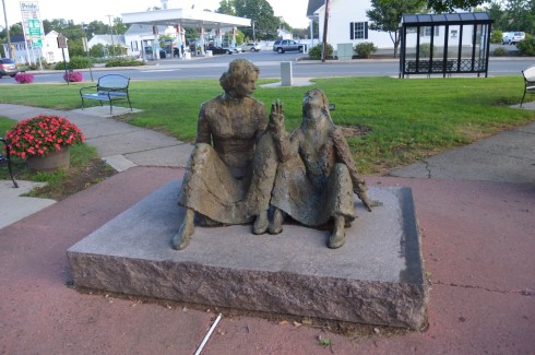
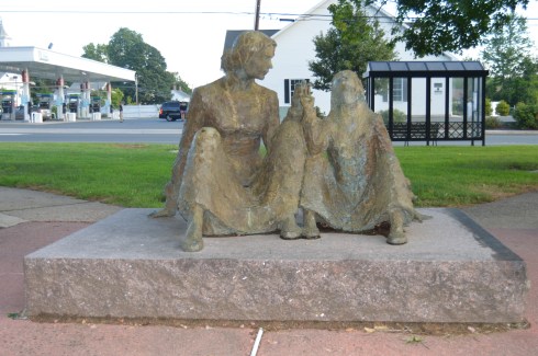
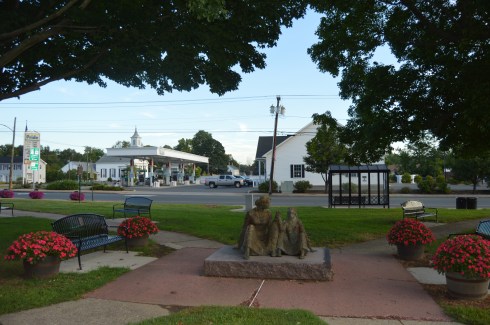
The centerpiece of the park is the monument of Anne Sullivan sitting with Helen Keller. The intensity in her stare is palpable. The sculpture, created by the Romanian-American sculptor Mico Kaufman, captures the moment Anne Sullivan successfully teaches Helen Keller her first word – “water.” The statue was dedicated on June 28, 1992.
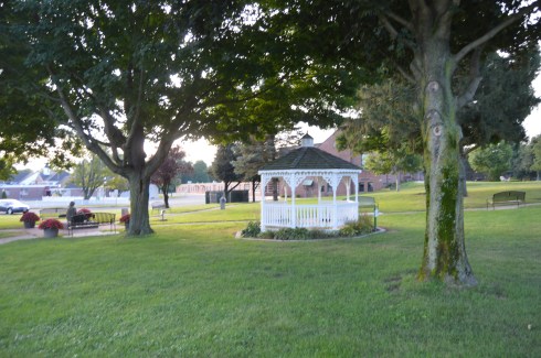
The park is well kept and there are many places to sit. A gazebo stands off to the side as well. It would be a peaceful place to relax and unwind, except the fact it is located at a busy intersection.
There are additional monuments in the park.
This memorial is another tribute to Anne Sullivan’s work with Helen Keller. The inscription reads, “Anne Sullivan…Teacher of Helen Keller. Heroic friend of the deaf and blind. Native of Feeding Hills.”
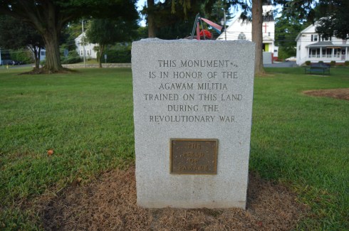
This memorial is a tribute to the Agawam Militia who trained on this land during the revolutionary War. I am always fascinated at how seemingly ordinary places like a busy intersection has so much history and significance. In fact, the land you are standng on, or the land your house or apartment building was built upon most certainly has a hidden history you are not privy to.
The trees at the Anne Sullivan memorial Park are very impressive, particularly when they still have their leaves.
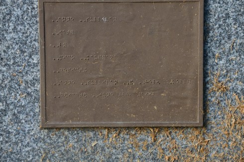
The last monument I photographed at the park names the people on the memorial committee. If you look closely, you may notice the inscription is also written in braille.
In the annals of presidential history, Quincy, Massachusetts, holds a special place. The birthplace of two U.S. Presidents; John Adams and John Quincy Adams, Quincy, MA, has earned earned the nickname “City of Presidents.” (originally, both Adams’ were born in Braintree MA but their birthplace became Quincy after Quincy split from the town of Braintree in 1792, John Hancock was also from Braintree before the area was renamed Quincy). In fact, the high school sports teams have adopted the menacing moniker, “Presidents.”
On this frigid Presidents Day, I decided to take a visit to the Old House At Peace Field, the retirement home of John and Abigail Adams as well as John Quincy Adams, when Presidents were really Presidents. The Adams’ and their future generations would call this home until 1927.
The Stone Library located adjacent to the Adams House.
The house is much prettier during the spring and summer. Flowers of a wide spectrum of colors adorn the walkway and throughout the estate. It is closed to the public until spring time. But the front gate was open, as though they were expecting me.
Further down the road on Hancock Street, in front of City Hall, stands John Adams.
I was wondering why he was looking off into the distance (wary of the British perhaps?). Then, I noticed a statue of Abigail and little John Quincy Adams was situated across the street.
Both of the Adams’ are buried in the United First Parish Church, located directly across from City Hall and, inconveniently for the drivers of Quincy, in the middle of the busy roadway. It is also the church I almost got into a fight at as a child until the other kid said he, “didn’t fight in churches” pffft. Oh, the memories.
There are other Adams’ residences and historical places, such as his original birthplace, also in Quincy, MA, that I will cover in later posts.
Parking is limited. There are about a 10-20 parking spaces but many people park sideways rather than horizontally since there are not clearly defined spaces in the lot. So, sometimes only a dozen or so cars can fit in the lot. It’s best to get there early in the day.
Hours: Sunrise to Sunset
No dogs or fishing are allowed since it is a reservoir.
Ashley Reservoir is a photographer’s dream destination. You don’t have to try hard to find pretty places to shoot. One of the things that stood out from my shoot was just how much the weather changed in the hour and a half that we spend there.
This slideshow requires JavaScript.
Ashley Reservoir is a 4 mile loop (there is a shortcut you can take that is about 1.5 or 2 miles). The trails are well defined and, when there isn’t snow and ice on the ground, would be easy to navigate.
One of the many interesting parts to the trail are the paths that seem to cut across the reservoir and connect back to the trails.
The photo below was not doctored. It is the particles in the snow as the sun melted the snow. But, I thought it looked pretty cool. The last video posted below shows these sparkles.
Since it is a popular destination for runners, walkers and nature lovers, the geese, ducks and other birds are not as skittish as they are in other parks and reservoirs. It was luncj time for the geese. The last video at the end of the post shows the sparkling snow.
This slideshow requires JavaScript.
Now, this is what I call a cluster duck.
Despite the cold temperature and the icy trails there were several runners out at Ashley reservoir.
The trees and plant life were grand even during the winter when some of them were bare.
This slideshow requires JavaScript.
Check out the videos below for more fun from Ashley Reservoir
stop by my Facebook page for my photos and fun stuff!
There are about a dozen parking spaces in the main parking lot. If needed, you can also park on the side of the road by the parking lot.
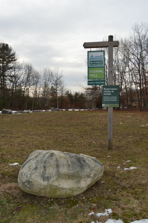
Cost: Free
Hours: open daily, sunrise to sunset
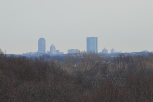
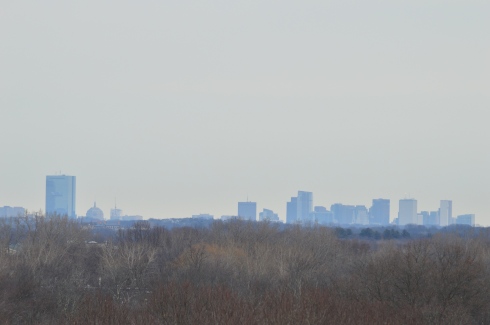
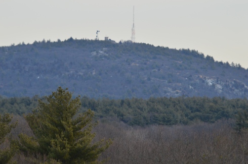
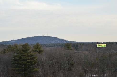
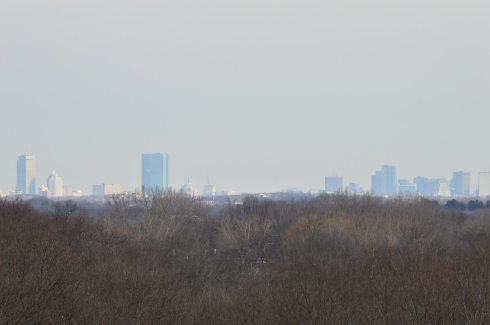
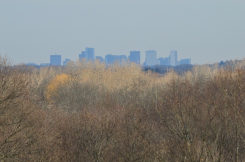
Before you even begin climbing the ascent to Signal Hill, the views from the parking lot are astounding.
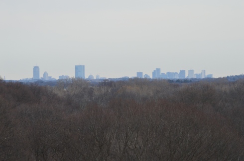
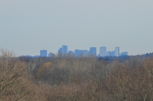
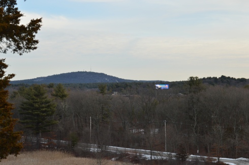
Besides the historical significance (it used to be the home to the Paleo-Americans who settled on what would become the Neponset River) and the active wildlife (hawks are said to nest there and many amphibians inhabit the area by the river), Signal Hill also offers grand views of the Boston Skyline, Blue Hills and the Neponset River Valley.
The hill to the scenic outlook at Signal Hill is modest at best. It should only take 10 minutes to go from the parking lot to the outlook.
The views are worth the short hike.
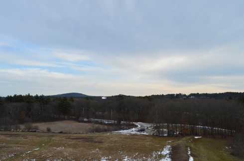
The scenic overlook has some pretty trees and rocks.
One of the charming features of Signal Hill is the short loop (1.6 miles) at the base of the hill. After climbing and trudging along so many long and steep hills, it’s refreshing to be able to take a leisurely stroll along the clearly defined trail. There are also trails that veer off a little.
Off the main trail there is a canoe launch site on the Neponset River. The upstream launch site goes to Norwood (MA) while the downstream site leads to Milton (MA).
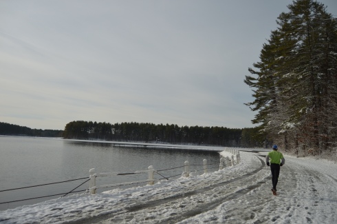
Since there is little traffic on the road, the road to Signal Hill is popular with joggers and cyclists.
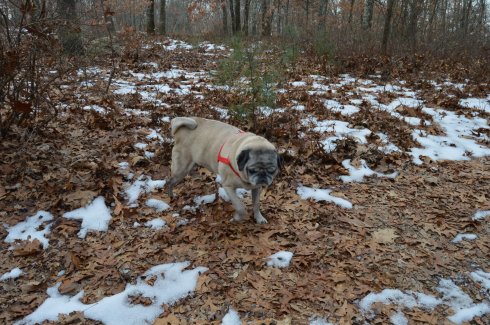
I met Charley during my visit. He was having fun playing in what remained of the snow on the trail.