Location: 305 Middleton St., No. Andover, MA (about 30 minutes north of Boston and about 1 hour southeast of Concord, NH)
Cost: There are several parking stations to pay per the hour or you can park at the headquarters which is what I did. There wasn’t a charge to park at the headquarters the day I visited. The charge to park at Berry Pond is $5 for MA vehicles; $6 for non-MA vehicles
Hours: trails are open sunrise to sunset. Berry Pond Beach is open 10am-6pm from June 25- Sept 5.
Parking: There are several parking lots throughout the automated pay stations.
Trail Size/Difficulty: 35 miles of logging roads and trails/easy with some challenging inclines
Handicapped Accessible: Yes, the main paves trail is and Berry Pond has several handicapped parking spaces right near the beach.
Dog Friendly: Yes
Highlights: wildlife, beach, lakes, extensive trail system, campground area, rock climbing
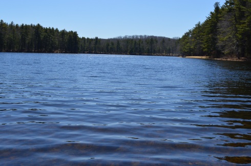
One of the more vast state forests I have visited to date, Harold Parker State Forest boasts over 35 miles of trails and roads, a beach (Berry Pond), several ponds and lakes and a variety of wildlife. I spent over 6 hours there and, while I did cover a lot of ground, there was surely some a lot I didn’t see. Tip of the day: if you do go, bring a trail map!
The trails at Harold Parker are generally easy with some moderate inclines. Due to the various streams and wetlands, there are also several boardwalk trails.
Harold Parker is a popular spot for cyclists. According to the New England Mountain Bike Association (NEMBA) the single track riding rates at Harold Parker State Forest are: 30% easy, 30% moderate, and 40% difficult with some rocky sections.
It is a little difficult finding the exact entrance to Harold Parker (I found 3 different addresses but I included the address of the headquarters at the top of this post). It’s not a bad thing, though, because you can park in any of the various parking areas. Just to make sure to pay at the pay station when you do park. You can also drive to each different parking area as the main road is paved and fairly wide enough for traffic, cyclists and hikers to share the road.
I began my day at Stearns Pond, one of the many ponds in the area. Fishing is allowed and I met a friendly fisherman who goes there regularly to cast his lines. They also allow non-motorized boating in the ponds. There is an annual fishing festival held in September at the state forest.
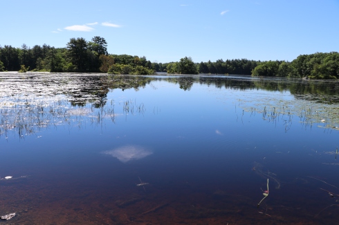
Stearns Pond is only one of the many ponds, rivers and streams at Harold Parker State Forest. In fact, it’s hard to keep track of which pond or river you are at, even with the aid of a map. But, there were some amazing views from the various bodies of water.
Unexpectedly, I came across this huge rock. I bet there’s a good story about this rock. I couldn’t find anything about in my research, though. It’s one big rock, though! Right!?
One of the highlights of Harold Parker is Berry Pond which is essentially a beach area and playground for children and families. It was a perfect beach day and the beach was packed. But, with photographic trickery I was able to photograph the beach without showing the sun bathers and swimmers. After all, not everyone wants to be seen in their Speedo.
Walking along the SKUG Reservation Trail, I came across the site of an old quarry and soapstone mill, the Jenkins Mill. There’s not much now to indicate it was once a quarry. If not for the marking on the map and a few rocks dispersed around the area, I would not have known it was once there. It’s kind of a shame that something that meant so much to so many people and was once such an important part of the area is now little more than a blip on the screen.
There are lots of birds, chipmunks, frogs and other critters visible along the trail and in the water at Harold Parker.
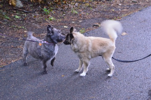
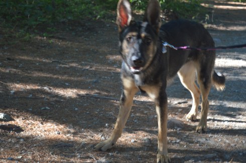
Harold Parker State Forest is a dog friendly park. However, I didn’t see as many dogs as I thought I would. I did manage to see these three cuties, though!
Suzie is a 7 month old English Setter. She is hearing impaired. So, she can hear some sounds. Her dad uses signals to help him communicate with her.
Bella (or “Bell”) is a 9 year old Beagle and Lab mix.
Herbie is a 1 year old Pit mix.
Below is a video of one of the brooks that runs through Harold Parker State Forest. Enjoy!
Please connect with me on Facebook to see more New England related content!
Parking: There are 15 total parking spots designated for the rail trail. There are 5 spots in the main parking lot on Friedenfels St at the entrance to the trail. There are also 10 parking spots across the street from the main parking lot. There is a larger parking lot in front of the main parking area that is a private lot. Don’t park there as your car could be towed.
Handicapped Accessible: Yes, the main trail is handicapped accessible. The side trails are not accessible due to the rocky trails and steep inclines. There is ramp to the right of the staircase to the trail at the parking area.
Dog Friendly: Yes
Highlights: scenic views, wide and easy trail, side trail, dog friendly, family friendly, benches to sit at, wildlife
Once the site of a grand railroad that ran from Boston to sections of Boston’s North Shore and New Hampshire, the Eastern Marsh Rail Trail is a true gem of the coastal section of the north shore (cities and towns north of Boston).
The railroad, which would be extended over time, began operating from Boston to Salem in 1838. It would later be extended to Salisbury and other territories in Massachusetts and New Hampshire in 1840.
Alas, the last train crossed the Merrimack River in 1965, leaving behind abandoned rail lines. Eventually, it was proposed that the rail lines should be converted to rail trails. Now, many decades later, instead of being used by noisy engines often carrying dangerous cargo, the rail lines are being used for exercise, dog walking and just enjoying nature.
The 1.4 mile Eastern Marsh Trail connects to the Clipper City Rail Trail to the south and the Ghost Trail to the north.
The Eastern Marsh Trail, which is part of a system of trails along the coastal north shore which includes Newburyport and Salisbury.
The trails at Eastern Marsh Trail are flat with no significant inclines.
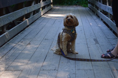
The Stevens Trail is a short trail (about .4 mile) that hooks up back to the main trail. There are some views and a cute bridge along the trail. You may see a few chipmunks along the way. It has some minor inclines but I would classify it as easy. This trail is not handicapped accessible due to the rocky terrain and a bridge that only has steps and no ramp.
The views along the trail are beautiful.
There are still remnants from the original railroad at the beginning of the trail. Maybe some day they will revive the rail!
This mural from the Salisbury Art Stroll held on May 13 was still remaining along the trail. I just missed it by a week. But, I may have to drop by next year to check out the art on display. This mural was a collaborative effort worked on by a group of artists.
There were lots of little critters on and off the trail. I would hear rustling in the trees or bushes in one direction only to be distracted by some other sound of activity in another direction.
Birds
turtles
and chipmunks
are just a few of the animals you may see on the trail.
But, birds, chipmunks and turtles aren’t the only animals who frequent the trail.
The trail is a popular with dogs and their walkers.
I love the “side eye” Peter, a 14 year old Golden Retriever, was giving his human walker in the first photo. All he wanted to do was greet me and say hi.
I love how May’s white fur looked against the background. May is a 6 year old Golden Doodle.
Look at the big smiles on Mako (on the right) and Murphy (on the left)! Mako is 6.5 years old and Murphy is 7 years old. They are both Labradors.
Nestled about half way between Boston, MA to the north and Caped Cod to the south, Marshfield, MA is a serene trail that also happens to bethe home to one of the best places for bird watching.
North River Wildlife Sanctuary actually has two sections to the trails. At least I consider them two sections. The trail from the nature education center
The trails at North River are easy with some slight inclines. Boardwalks allow access over marshland and wetland. However, not all of the trails are on clearly marked trails. Look for yellow and blue marked trees to ensure you stay on the trails. .
Along the trail closest to the nature center, there is a trail that is mostly dirt with soem gravel paths and boardwalks. If you do take some side trails (I suggest you do), you may come across some trails like the one pictured above that is covered in leaves and not clearly defined. Most trails are even with some minor inclines.
Along the trails there are some educational and recreational objects.
This sign identifies a certain type of bark and needles along the trail. There is also a tent for visitors to play with. There used to be two of them but they felt it made visitors too tense.
The Woodland Loop (the main trail from the educational center) leads to the Hannah Ames Trail (named after a former resident of the land). The 2.5 mile loop is easy with some pretty views. I heard lots of birds but failed to photograph many of them (this is atheme with my visit as you will see later). But the views are pretty and a boardwalk covers some wetland.
The gem of the sanctuary, has to be the trail that leads to the boardwalk with the observation platform by the North River. The signs for the River Loop trail, which veers off from the Woodland Loop after a quarter of a mile or so, are sort of tucked away. As a reference point, if you reach the tent on the Woodland Loop you’ve gone too far.
Once you cross the busy Summer Street (be careful), you will see a trail that leads to an open area with views of the North River in the distance.
There is a well worn grass trail that leads to a boardwalk over a wetland area. Trust me, there is a bird in the first photo in the bottom row. I swear.
The boardwalk leads to a very cool observation platform with cattails and other plants and trees along the sides of the platform.
The views from the platform are very pretty. I didn’t see much bird activity and it was a fairly cold day with a blustery wind during my visit.
After leaving the platform area, I noticed a somewhat hidden trail, the Red Maple Loop. For some reason, perhaps because of the thick brush and because it is heavily wooded, this is where I saw and heard the most activity. In fact, I saw some bucks while I entered the trail but they caught me by surprise and I couldn’t get their photo. There were lots of birds on this trail though. Again, they’re very hard to photograph. But, I did manage to photograph a few of them.
This Mass Audubon site also utilizes solar power as part of their commitment to the environment.
Below is a video from the observation platform by the North River. As you can tell by the audio, it was a pretty windy day!
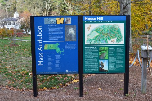
Moose Hill Wildlife Sanctuary in Sharon, MA, may not have moose but it has everything else that makes a sanctuary the perfect place for a weekend hike. Pretty flowers and trees, scenic views and wildlife are plentiful at Moose Hill.
The nature center at Moose Hill was decorated for the autumn season with pumpkins and a quilted figure.
The trails at Moose Hill are, for the most part, easy with some modest inclines, except for the trail up to the fire tower. There is also a boardwalk over a red swamp area and some other boardwalks that are a nice touch.
The trail to the fire tower is challenging but it’s not too difficult. It’s a short incline up to the tower. Unfortunately, it appears to be off limits. Usually, signs and barriers don’t stop me but I draw the line at barbed wire. It’s too bad because the views must be amazing.
Instead of the fire tower, there is a great overlook at the Bluff Overlook on, oddly enough, the Bluff Trail. Most of the trees have shed their leaves but yyou could still see some pretty colors out there. I especially liked the branches in the first photoon the left hand side of the group of photos.
It is easy to find beautiful areas to photograph in Moose Hill all year round. Ideally, foliage season would probably be the best time to visit. I just missed the peak foliage season but it still looked beautiful. The shapes of the trees and the way the rocks form borders in the different sections of the park make for great photo opportunities. It really doesn’t take a lot of effort or talent to find the beauty of the sanctuary.
There is also a beekeeping harvest hive and a real hive located near the harvest hive. Both looked inactive. A bench sat precariously near the now destrcuted hive. “Be At Peace” is engraved on the backing of the bench. Good advice.
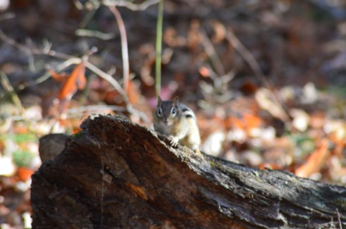
I was a little disappointed by the lack of visible wildlife during my visit. I got there early (between 7 and 7:30) but I still didn’t see any of the larger wildlife that is known to be there such as deer, foxes and coyotes. I did see these little critters, though.
chipmunk, Moose Hill Wildlife Sanctuary, 11-13-16
red squirrel, Moose Hill Wildlife Sanctuary, 11-13-16
And this owl.
Fooled ya!
But, this owl is an actual part of the sanctuary. It’s part of the “unnatural trail.” The unnatural trail is a family friendly trail that is geared more for children. The trail is about a quarter of a mile that has objects that you normally don’t find on a trail (like shovels and shoes for instance). The children are then asked to identify the randomly placed objects and answer questions about what was on the ttrail.
There is also the Billings Barn (the white building) and a maple sugar shack which campers use to make sugar from the sugar maple trees. During maple sugar harves season, the campers and people at the sanctuary leave buckets attached to the trees to harvest the maple sugar from the trees.
Location: 1361 Middleboro Ave, East Taunton, MA (about 45 minutes south of Boston, MA)
Cost: Free this time of the year. Seasonal prices are not posted on the web site or at the park.
Hours: Open Daily 7:00 a.m. – 4:30 p.m. (hours may vary depending upon the season)
Parking: There were roughly 50 to 60 parking spots in the lot
Handicap Accessible: No. The side trails can be very rocky and, in some areas difficult to navigate. The main road is paved but cars and other vehicles do travel along the road often.
Dog Friendly: Yes
Time To Spend During Visit: 2 to 3 hours
Highlights: pretty trees, pretty views, bodies of water, dog and horse friendly, cranberry bogs, boat launch (the seasonal camping sitees have not been opened since the 2008camping season)
Named after the sachem, or leader, of the Wompanoag Confederacy, Massasoit State Park boasts 1,207 acres of trails, 5 bodies of water and a beach area. Add to that some pretty sweet views.
The first thing you’ll notice, and perhaps the main attraction, at Massasoit State Park are the cranberry bogs. The colors of the cranberry and the trees clash to make some pretty contrasts, particularly during foliage season.
The trails at Massasoit State Park are mostly easy with a few moderate inclines. There were a few boardwalks and makeshift bridges made out of trees and other debris.Many of the trails were carpeted with leaves.
Signs of foliage were everywhere. Trees burst with orange, red, yellow and green this time of the year.
Massasoit has 5 ponds and a beach area. The bodies of water are surrounded by pretty trees and vegetation.
Swans and other birds inhabit the ponds.
As you can tell by the photos, the weather changed about, oh, 16 times during the day. In other words, it was your typical New England day. It rained, hard at times, for short periods of time and the sun crept out as well.
Another thing I noticed at Massasoit State Park are the rocks. There are white rocks placed throughout the park and other big rocks with crystal-like elements in them.
The park is also popular with cyclists. I saw dozens of cyclists during my visit. This friendly cyclist was nice enough to let me photograph him.
With its wide paved trail and abundant side trails, Massasoit is the perfect place to bring your dog and I saw several dogs enjoying the fall weather during my visit.
Rex is a 6 and a half year old Blue Tick Coon Hound. Never heard of a Blue Tick Coon Hound? Join the club. Apparently, Blue Tick Coon Hounds are hunting dogs that are prevalent in West Virginia, which is where Rex is from.
Granger is a 4 year old Black Mouth Cur.
Cocoa is a 10 year old Chihuahua and terrier mix breed. He lives nearby and visits the park often.
I also saw these two playmates at Massasoit.
Grace, a 2 year old Doberman and Sydney , a 1 year old Golden Doodle, affectionately played at the park.
Please connect with me on Facebook to view photos, videos and other content that is not posted in this blog: New England Nomad
Parking: There are about 30 parking spots at the entrance to the park. There is also off street parking and parking available down the street at Kasabuski Arena (201 Forest St).
Cost: Free
Hours: Open everyday sunrise to sunset
Size: 640 acres
Time To Allot For Visit: At least 1 to 3 hours
Trail difficulty: Easy to Moderate in some areas
Dog Friendly: Yes
Fun For One: Yes
Highlights: scenic views – especially from Eagle Rock, beach, play area for children, trails for cycling and running, fishing is allowed
Lowlights: side trails end without warning, some rocky terrain
Once a hunting ground and camp area for Paleo Indians as far back as the Archaic and Woodland eras (roughly 1000 – 2000 BCE), Breakheart Reservation boasts two grand lakes, scenic vistas, a beach, a play area for children and miles of trails.
The trails are mostly easy with some moderately difficult trails and inclines. The side trails can be challenging more because of the rocky and narrow terrain rather than the inclines. The one downside to taking the side trails is that some of the side trails end without warning, such was the case with the Saugus River Trail which is one of the first side trails you will see when you enter the park. The Cedar Glen Golf Course abuts the park. So, you’ll hear and see golfers whacking their golf balls around. Also, one side trail leads to the children’s camping site which you’re not supposed to access and yet another trail just ends near a store’s parking lot. So, you end up walking long distances only to have to turn around. If you want to avoid walking on trails that end suddenly, it’s best to stay on the main trail and the trails that loop around the lake.
The two lakes at Breakheart Reservation, Pearce Lake and Silver Lake, have trails that loop around the bodies of water.
Pearce Lake (considered the lower pond) has a beach and some very pretty views. It runs along the main trail and along some of the side trails. It is the larger of the two lakes and it is where the beach is loacted.
Although Lake Pearce is the larger of the two lakes, I found Lake Silver (the upper pond) to be more intriguing than Lake Pearce.
Lake Pearce has two smaller islands in the lake. One of the islands is accessible via a makeshift walking bridge of branches, sticks and anything else that you can walk on to get to the island. Except for some pretty views there wasn’t much on the island.
At an elevation of 206 feet, Eagle Rock offers scenic views of the Boston skyline and surrounding areas. One suggestion I would make if you do try to climb up to Eagle Rock (it’s a moderate climb) is to use the “back” way to the vista (aptly names Eagle Rock Trail). I went straight up along the rocky edge along the Pearce Lake Trail and it was more challenging than it would have been if I had gone up via the trail on Eagle Rock Trail. There are other points of higher elevation on other trails such as Castle Rock and Crow Hill.
There are many other beautiful and interesting things along the trails at Breakheart Reservation.
This slideshow requires JavaScript.
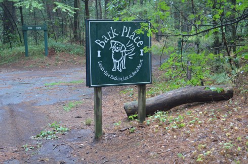
Breakheart has a paved main trail which is usually packed with runner, cyclists and people walking their dogs, especially at the Bark Place where dogs are allowed off leash for a section of the trail.
Breakheart Reservation stopped allowing vehicles on the trails some time ago. It was great not having to look over your shoulder or carefully turn a corner worrying if a car or other vehicle might be coming your way. It also allows lots of room for all the walkers, runners and, of course, the dogs that frequent the park.
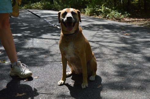
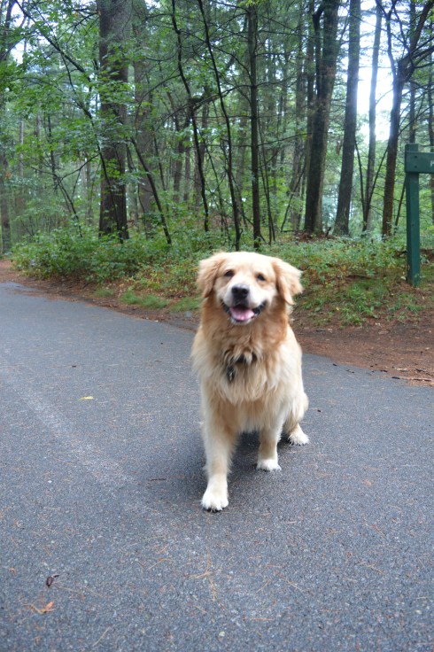
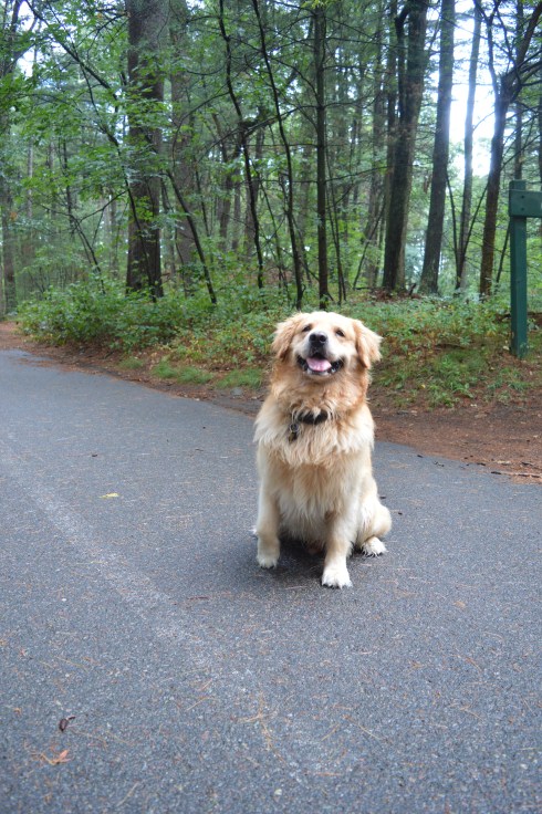
These dogs had a great time at Breakheart Reservation during my visit…
Location: Dorrs Pond is part of Livingston Park which is located at 244 Hookset Rd, Manchester, NH (off Daniel Webster Highway)
Hours: Open 24 hours (use your best judgment if you go at nighttime)
Cost: Free
Parking: There are about 70 or so parking spots by Dorrs Pond. There is also additional parking by the play area and field by Livingston Park.
Dog Friendly: Yes
Size: 1.2 mile loop with some short side trails.
Time To Allot For Visit: 1 or 2 hours
Fun For One: Yes
Highlights: abundant wildlife, popular trails for runner, cyclists and walkers, pretty views, very well maintained, benches for sitting, skating on the pond during the winter
Lowlights: short loop (only 1.2 mile) so many runners have to complete the loop several times to get a good workout, some side trails end abruptly at parking lots or just stop without going anywhere
Once an artificial pond to serve the people of Manchester, Dorrs Pond now serves a scenic retreat for cyclists, runners, nature lovers and dogs.
“hidden gem” is a phrase that gets thrown around a lot. But, the photos below will show how this description is apt for Dorrs Pond. In fact, I, and many people I talked to about it, had never been to this pond or ever even heard about before I went there.
One of the great things about Dorrs Pond is it is not a particularly difficult trail. The trails are Dorrs Pond are pretty level with a few small inclines
The views at Dorrs Pond are beautiful. Vivid greens and a variety of green, purple and other vibrant colors dot the landscape.
One of the best parts of Dorrs Pond is the wildlife. There is a variety of birds, amphibians and other animals at the pond.
I also found this interesting shelter. Unfortunately, no one was home.
During the winter, skating is allowed on the pond. Also, there is a play area, playing field, restrooms and pool for children (and some adults) in addition to Dorrs Pond at Livingston Park.
Doors Pond is a great place to bring your dog. The trail is not too long and the inclines are not very steep. And it was a perfect day for taking your pooch out for a stroll. I saw lots of dogs at Dorrs Pond. Here are a few of the cute dogs at the park Sunday:
Parking: There are about 50 parking spots. You shouldn’t have too much of a hard time finding parking unless there is an event or summer camp is in session
Size: 12 square miles
Time To Allot For Visit: I was there 5 hours and I still didn’t see everything but you can take in most of the best parts of the park in 2 to 3 hours
Dog Friendly: No, most Audubon parks are not dog friendly
Highlights: bodies of water, plentiful wildlife, pretty flowers and plants, observation tower, canoe rentals (if you’re a Mass Audubon member)
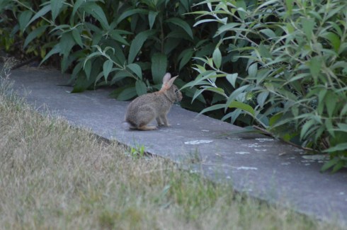
From the moment I walked to the visitor center at the Mass Audubon Ipswich River Wildlife Sanctuary, I encountered wildlife. In fact, I found this rabbit chewing on some greenery in the shrub by the office.
That is the great thing about Ipswich River Sanctuary. If you’re an animal lover, or even if you just like them a little, then you will love this place.
Not only are the animals abundant, they are also relatively friendly and not all that shy. Well, most of them weren’t too shy.
This slideshow requires JavaScript.
The well-fed red squirrel let me get very close to him or her, so long as I didn’t affect his or her food supply. A lady who had been sitting there on the bridge wall before I arrived has been intentionally leaving seeds or some other type of food the squirrel was enjoying which allowed me to get some great shots. Thanks, random lady!
There are also a wide variety of bugs and other insects at the park. Bug spray and covering up are a must (I especially suggest a hat since one particular bug kept landing in my hair). And most bug sprays don’t stop all bugs. The black insect below was particularly menacing. Also, I never saw so many dragon flies in one spot as I did at Ipswich River Sanctuary but they were pretty harmless.
There are some beautiful views and plant life at Ipswich River Wildlife Sanctuary. The colors of the flowers really pop out and the trails are well defined. Many of these pretty features of the landscape were created 15,000 years ago by a glacier.
This slideshow requires JavaScript.
You can also rent canoes, if you are a member, for $10/hour for a minimum of 2 hours. So, the cost is $20 or more. You pay for the canoes at the front office and then you have to lug the paddles and life vests along with a key to the where the canoes are locked up (about a half a mile or so away) at the canoe launch. The canoe launch is right next to where the canoes are locked up.
One thing I have seen at other parks that is present at Ipswich are bat boxes. These bat boxes are designed to give daytime roots for little brown bats. Bats are important because they eat lots of mosquitoes and other insects, the plaque next to the boxes explains (then get more bats there please). Little brown bats have been the victims of white nose syndrome,an illness which has been affecting brown bats while they hibernate during the winter. The cause is not yet known. So, the boxes are meant to give them a safe and convenient way for them to rest. The boxes were constructed by Eagle Scout Sean Enos and Boy Scout Troop 48 of Lynnfield, MA. The lumber was donate by a local business.
There is also an observation tower at Ipswich Wildlife Sanctuary. The three story tower built of wood is a little shaky but safe. The tower overlooks a swamp and meadow. There wasn’t much wildlife except for the very occasional bird (I included photos of the egret and other bird who landed in the water in the earlier slideshow). I think that is you had unlimited time and a lot of patience as well as a good set of binoculars (I didn’t have any of those things) you could see a few grand birds.
This slideshow requires JavaScript.
One of the things I noticed and I had not seen before my trip to Ipswich are pink water lilies. I have seen white water lilies but never saw the pink water lilies until my visit there.
Like most Mass Audubon sanctuaries, the Ipswich River Wildlife Sanctuary is well kept and family friendly. The grounds are well manicured and there is even a play area for children. They also have a summer camp program where they teach children about nature in a fun and exciting way. All in all, the Ipswich River Wildlife Sanctuary is a fun and exciting place for people of all ages.
Cost: Free since I visited during the off season. It costs $8 for MA vehicles and $10 for out of state vehicles once the main season begins (around early May)
Parking is limited. Since it was not the peak of the season, I found a spot without any trouble. But, there are only 20 or so spots in the main parking areas. There are some additional parking areas off the main trail to the lake.
Boats are not allowed in the water, although fishing is allowed. Trout and bass are the most common fish in the water.
I had been interested in visitng Rutland State ever since I heard about the remnants of the state prison camp and the views of the water.
There was a strong wind, evident by the ripples in the water.
This slideshow requires JavaScript.
The gates at the entrances to some of the trails prevented some vehicles from entering the trails. This is because during this time of the year it rains a lot and bikes and other vehicles can get stuck on the trails. So, it was a pretty empty trail when I went. Which was just fine by me. Miles of near solitude in nature with a cloudless, cold blue sky on a bright New England morning….yes please!
The main trail I stayed on was easy with some moderate includes. The only thing you may find annoying is the long stretches of nothing but trees and water on each side of the trail. This was heaven for me, though. I was also pleased to see a dirt trail rather than gravel or, gasp, paved road.
As I continued on the main trail, I began to see signs of ruins of structures frozen in time. A stairwell and frame of a building, now adorned with graffiti (get used to it as it is a constant theme), stood on the outskirts of the trail.
At around the 2 mile mark of the trail there are remnants of a prison camp. The camp was constructed in 1903 for housing petty criminals. It would later be converted into a farm. The first structure, again riddled with graffiti, was used for solitary confinement.
When you consider just how small and confining the spaces in the building are you can only imagine the distress it caused some of the prisoners.
Something happened when I visited the remnants of the prison camp. What I had once considered “cool” and interesting, seemed dank and sad. In fact, it wasn’t until after I left the structure and cave that it really sunk in. It seems like a grim existence at the least. When you realize people lived in these conditions and suffered, largely for committing petty crimes (such as drunkeness), it makes you think we should be more cognizant of the history of the building and area. If it wasn’t so tragic it would be more interesting. Rather than being “cool”, it just made me depressed.
Farther along the trail is an arch that appears to be a root-like cellar. I am not sure what it was used for but my gut tells me nothing good.
There are also some interesting tunnels and holes in the ground at the old prison site. I decided to investigate.
Given the architecture of the structures and the history of the area, it is easy to see why the park is considered haunted. Disembodied voices and apparitions are said to have been witnessed by visitors. There are even claims the area was once used for satanic worship. The area was the subject of the book The Soul Collector, written by Joni Mayhan.
On a brighter note, I saw lots of four legged friends at Rutland State Park.
(left to right) Grayson, 7, an American Pit Bull Terrier and Gamble, 6, a Pit Bull and Boxer mix.
Blackie, 4 years old, a part husky.
I also saw some other four legged friends.
Panda, in front, is a training horse. Calvin is the horse on the right and the horse in the back left (who is difficult to see) is Jack.
There were also a few kids playing on their motor bikes and ATV’s.
The videos below are some videos from my visit. Thank you for reading!
New Hampshire isn’t known as the “Live Free Or Die” state for no reason. The quote, which is said to have French origins and adorns license plates and other kitschy souvenirs, is directly attributed to General, and former New Hampshire resident, John Stark. It was at John Stark Park in Manchester, NH, that I found this historical tribute to the revolutionary warrior.
The remaining of the “live free or die…”quote is lesser known, yet just as poignant.
For someone who is so heroic and brave, General Stark is not someone who many of us are familiar with. But, heroic he is. As the plaque in front of his statue explains, after being kidnapped by a Native American tribe and eventually ransomed, Stark joined the American Revolution and became a general. His most notable achievement was in 1777 when he commanded his troops to prevent British troops and supplies from connecting with the main army in Saratoga, New York, which was considered a key point which led to the American victory in the war.
Crisp blue skies awaited me at the park. It almost felt fall-like. What struck me most about the park was how peaceful it was. The gazebo is a nice touch also. The statue of General Stark was sculpted by Richard Recchia in 1948. The park is one of the older parks in New Hampshire, dating back to 1893 (it is the second oldest park in Manchester).
This slideshow requires JavaScript.
General Stark his, wife and a few of their children are buried at the bottom of the hill from the entrance.
One of the interesting things about Stark Park is the loop behind the park. It’s only about a quarter of mile and it is a great place to take your dog for a walk. But, there is a trail that branches off to a bridge and some other trails which eventually lead to the Heritage Trail. But, apart from some interesting trees and some wildlife, there isn’t much on the trails. Most of them lead to residential areas. I walked most of the narrow trails as far as I could go before they ended, rather disappointingly, at roadways and residential areas.
The big payoff to walking the loop behind the park was meeting Bennie. Bennie is a Chinook which is the state dog of New Hampshire.


 Blackie, 4 years old, a part husky.


