Parking: There are several parking lots at the Greater Worcester Land Trust which the Cascading Waters is part of. The closest lot to the Cascading Waters is small with only room for about half a dozen cars. You can also drive up to Cascading Waters via Cataract St and park on the dirt road there.
One of the great things about Worcester (pronounced “Woo-stah”) is its diversity of people and places. One moment you could be in the heart of the city and only ten minutes later you could be at a grand waterfall. It remind me a lot of Boston in this regard.
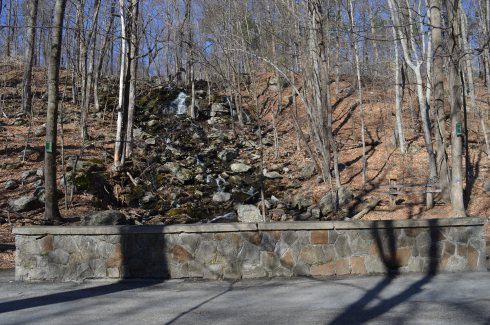
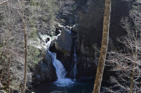
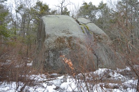
I found myself at one of the natural wonders of Worcester, Cascading Falls, Saturday.
Located about an hour west of Boston, Cascading Falls is known for its beauty and trails. There are both hiking and biking trails at the main parking area. I chose the most direct hiking route to the falls. The trail is pretty flat and straight with some pretty views. I also noticed some greenery sprouting on the eve of the first day of Spring. it’s about half a mile to the Cascading Waters from the parking area.
There is a trail to the right of the falls with a fairly steep incline. The trail leads to the top of the falls. You can go to the top of the waters. The views are pretty sweet.
This slideshow requires JavaScript.
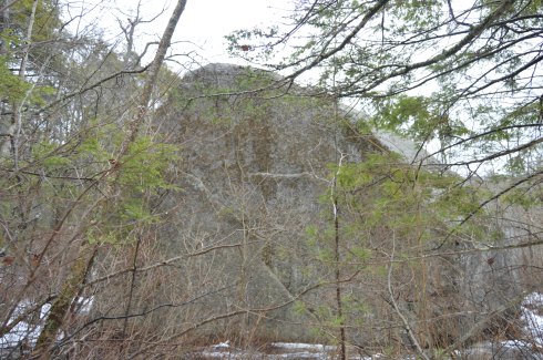
There are also interesting rocks, pools of water and streams at the top of Cascading Waters.
This slideshow requires JavaScript.
Although the sun was out and the temperatures did increase, it was still relatively cold as this branch shows.
The waterfall leads to a stream just under and behind the trail.
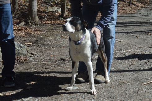
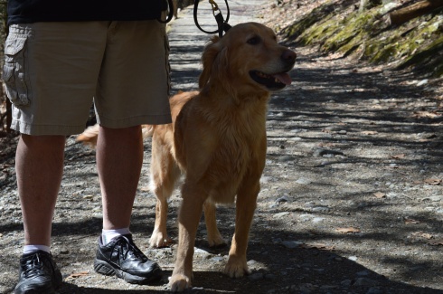
Cascading Waters is a great place to take your dog for a walk. I met two golden retrievers; Wilson (on the left ) and Tucker, while I was there.
Below are two videos of Cascading Waters from the trail view and view from the top of the falls.
Location: Beech St, Manchester, New Hampshire (with access points on Union, St, Amherst St and Hanover St)
Cost: Free to the public
Although a statue that is dedicated to the veterans of the Spanish American War, the Boxer Rebellion and the Phillipine-American War, Bronstein Park celebrates a hero from another war.
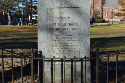
Although “The Hiker” stands prominently at the street entrance to the park, Bronstein Park (formerly known as Hanover Square) is actually named after a corpsman who died in World War II; Dr. Ben Richard Bronstein, the first Manchester, New Hampshire, resident to die during the war. Dr Bronstein’s brother, Maurice Bronstein, donated the memorial to the park in 1990.
The inscription on the memorial is hard to read in some parts. It states:
“in memory of Dr. BEN RICHARD BRONSTEIN, LIEUTENANT, MEDICAL CORPS, aboard the destroyer U.S.S. Jacob Jones Lost in Action, February 28, 1942 First Naval Officer From the State of New Hampshire To have Sacrificed his life in the fulfillment of his duty in World War II.”
Another memorial pays tribute to Dr. Bronstein’s brother, Stephen Max Bronstein, who also served during the war.
“The Hiker” was originally sculpted by Theo Alice Ruggles Kitson in 1906. The original statue was made for the University of Minnesota. However, 50 copies were made of her statue and were distributed all over America. Manchester, New Hampshire was the recipient of one of the copies of her statue. The statue is made of bronze on a base of granite, of course.
The name “hiker” was a moniker the American soldiers in the Spanish American War and Philippine-American War gave themselves because of the long hikes they took in the jungle. Kitson said the hiker, “depicts a hero stripped of his parade uniform and shown as a soldier reacting to the challenges of the battlefield.”
Leonard Sefing, Jr., a Spanish-American War veteran, was the model for the statue.
A close inspection of the statue shows a weary soldier clad in civilian type apparel.
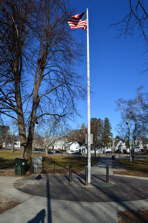
An American flag stands in front of the memorial for Dr. Ben Bronstein.
One strange thing I noticed is a warning posted that prohibits people from hanging out at the park during school hours. So that is something to bear in mind if you do visit. I’m not sure why this restriction is in place. I can only imagine you would be the talk of the town in prison if you ever got convicted of it “Don’t mess with that guy. He’s in here for loitering.” (I know it’s probably just a fine)
Below are some additional photos of the park from different angles.
Arms Park is a unique kind of park. In fact it’s not really a park at all. A stream, fed by the Amoskeag Fishways, runs parallel to the park. It is the perfect place for people who love the sound of water and watching waves (and based on my previous posts I know you’re out there). There’s not much to Arms Park. A parking lot takes up most of the area (which has led some to call it “Arms Parking”) and a few office buildings dot the landscape. It’s certainly not one of the most picturesque landscapes but the stream and walkway does have a certain charm. It is often used for observing important important days such as the annual Pearl Harbor Day observance event and the Fourth of July fireworks display.
The river is usually pretty rough and could consequently be dangerous if anyone got caught up it in.
This slideshow requires JavaScript.
It was still fairly cold when I went to visit, so the water which did splash on the railing quickly turned to ice.
A variety of birds like to seek refuge at Arms Park. I saw a bunch of gulls there during my visit.
Arms Park has a short walkway along the river with benches along the way.
The video below gives a better representation of the choppy water at Arms Park.
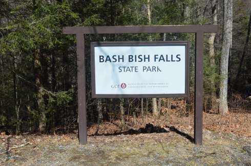
Located in the most southwestern part of Massachusetts, Bash Bish Falls is considered one of the most dangerous waterfalls in not only Massachusetts but the entire United States. It is also one of the most beautiful.
According to legend, Bash Bish was the name of a Mohican Native American woman who was accused of adultery which was punishable by death.. Bash Bish was pushed over the falls while tied up in a canoe.
The shape of the falls is said to resemble a woman falling to her death. Another theory claims the segmented characteristic of the falls resembled the reuniting of Bash Bish and her daughter White Swan who had also disappeared over the falls according to the Mohican legend. If the rapids of the stream leading from the waterfall and the speed of the water falling from the waterfall are any indication, the restless spirits may still be there. It is also a good reason why swimming is not allowed as the rapids can be very strong and it is easy to hit a rock.
This slideshow requires JavaScript.
Bash Bish Falls is located in Massachusetts, just past New York/Massachusetts border.
There are several entrances for Bash Bish. One of the entrances, at the top of the hill from the Massachusetts entrance on Falls Rd, gives ample evidence as to why Bash Bish may be considered such a dangerous waterfall. The stairs, which are a generous description, and walkway, also a generous description, are rocky and treacherous. There is a railing to hold on to. But, it’s still a tricky path.
I would recommend using the first parking spot on Falls Rd, if you’re traveling from Massachusetts. The trails are easy to moderate with a few slight inclines from the first parking lot. It is a 3/4 mile walk to the waterfall from the parking area.
There are many interesting rock formations along the trail. Little known factoid: I learned a new word recently for the strange piles of rocks stacked creatively that we often see along trails and at beaches like the rocks in the first two photos in the top row of photos below. They are called cairns, unless you ask a conservationist or geologist in which case they will condescendingly call them just rock piles since real cairns are nature made and not man made.
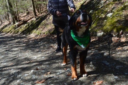
Bash Bish Falls is a popular spot for dog walkers. I met the following dogs during my hike.
Charlie
Juno, a Rottweiler and Shepherd mix
Cassie, a Bernese Mountain Dog.
Murphy, a beautiful Golden retriever
To get a better perspective of the waterfall and the stream leading from the waterfall, I have attached the following videos.
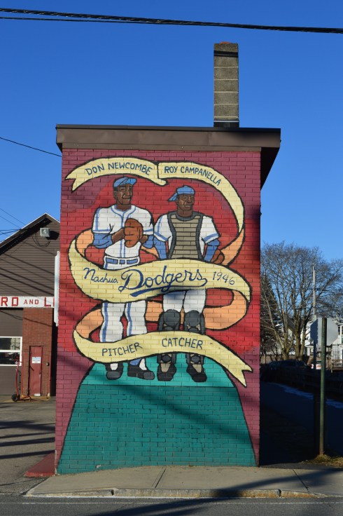
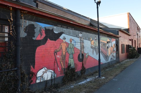
Location: 31 West Hollis St., Nashua, New Hampshire The mural can be seen on the east side of the Maynard & Lesieur building
Most baseball fans know the Dodgers were the first American professional baseball team to integrate baseball in decades. However, few people know it was the Nashua Dodgers (the farm club of the Brooklyn Dodgers) and not the Brooklyn Dodgers that were the first pro team to integrate an American baseball team in the 20th century (Jackie Robinson, who would later become the first African American to play professional baseball in the United States during modern era, was playing for the Montreal Royals of the International League at this time).
It is said that Branch Rickey and his executive, Buzzie Bavasi, chose Nashua as the location for this New England League team partly because the city had a large French Canadian population and they felt the French Canadian people would be more receptive to an integrated team.
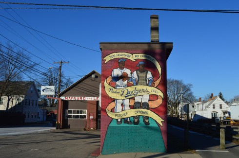
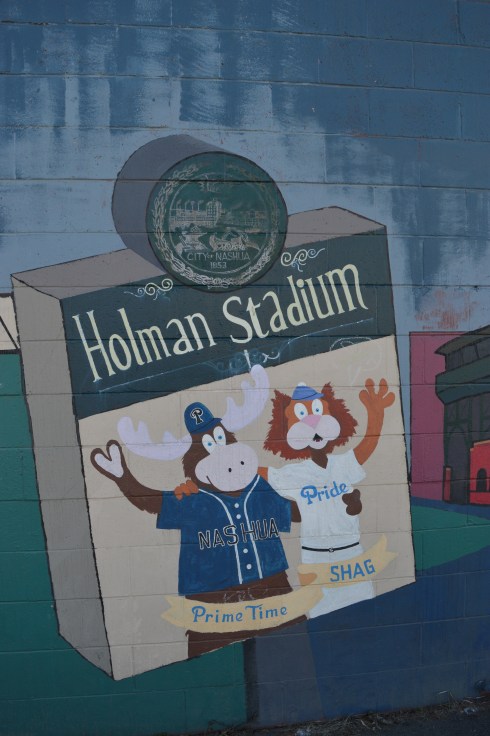
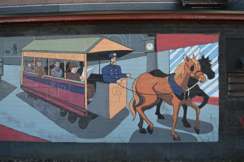
Along the side of the building with the Nashua Dodgers mural is another work of art. The mural celebrates the earlier days of Nashua. Holman Stadium, which is prominently displayed in the mural, is the stadium the Nashua Dodgers played in. It is still in use to this day. It is now the home of the Nashua Silver Lights of the Futures Collegiate Baseball League.
The mural is such a pretty work of art. Unfortunately, it has sustained some damage due to people defacing the artwork.
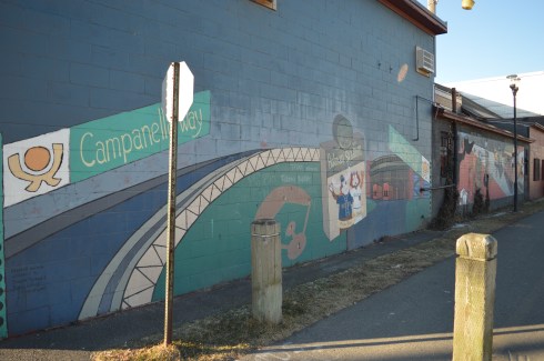
Below is a walk through of the mural on the side of the building.
New Hampshire isn’t known as the “Live Free Or Die” state for no reason. The quote, which is said to have French origins and adorns license plates and other kitschy souvenirs, is directly attributed to General, and former New Hampshire resident, John Stark. It was at John Stark Park in Manchester, NH, that I found this historical tribute to the revolutionary warrior.
The remaining of the “live free or die…”quote is lesser known, yet just as poignant.
For someone who is so heroic and brave, General Stark is not someone who many of us are familiar with. But, heroic he is. As the plaque in front of his statue explains, after being kidnapped by a Native American tribe and eventually ransomed, Stark joined the American Revolution and became a general. His most notable achievement was in 1777 when he commanded his troops to prevent British troops and supplies from connecting with the main army in Saratoga, New York, which was considered a key point which led to the American victory in the war.
Crisp blue skies awaited me at the park. It almost felt fall-like. What struck me most about the park was how peaceful it was. The gazebo is a nice touch also. The statue of General Stark was sculpted by Richard Recchia in 1948. The park is one of the older parks in New Hampshire, dating back to 1893 (it is the second oldest park in Manchester).
This slideshow requires JavaScript.
General Stark his, wife and a few of their children are buried at the bottom of the hill from the entrance.
One of the interesting things about Stark Park is the loop behind the park. It’s only about a quarter of mile and it is a great place to take your dog for a walk. But, there is a trail that branches off to a bridge and some other trails which eventually lead to the Heritage Trail. But, apart from some interesting trees and some wildlife, there isn’t much on the trails. Most of them lead to residential areas. I walked most of the narrow trails as far as I could go before they ended, rather disappointingly, at roadways and residential areas.
The big payoff to walking the loop behind the park was meeting Bennie. Bennie is a Chinook which is the state dog of New Hampshire.
Parking: Off street parking and parking lots are available throughout the area
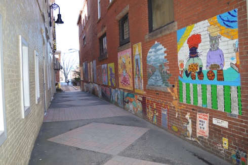
Location: Dean Ave., Manchester, NH
Dean Avenue, also known as the hardest place to find in Manchester, is home to Cat Alley – an alley full of cats.
I must have asked a dozen people for directions to this alley way until one older gentleman chuckled and sent me in the right direction. A lot of people got it confused with the “Alley Cat” (a popular pizza joint in the area). Don’t go there as it is not even close to the “Cat Alley.” The hidden alleyway is easy to miss. It is located between Lala’s Hungarian Pastry (mmmm) at 836 Elm St and Alpha Loft at 844 Elm St. There is a sign on the shingle of Lala’s indicating Dean Ave.
There are cats everywhere in Cat Alley.
The name “Cat Alley” precedes the art on the walls. According to legend, the name was derived from a business man witnessed two stray cats duking it out. I sure wish he had broken it up. At any rate, after noticing the alley way, which I might not recommend walking down too late at night, a business man decided to raise funds and hire street artists to give the alley the look it deserves. Below is a slideshow of all of the art as well as a video of a walk through of the alley.
This slideshow requires JavaScript.
Cat Alley isn’t the only place I found graffiti, much to the chagrin of many Manchester residents I am sure. I found this mural on Manhattan Lane, a side street parallel to Elm St. This mural is spot on, minus the recycling bins. From left to right is the “Man In The Mountain” (which, as a child, I used to call the “Old Man In The Mountain”) – a rock formative created by wind, erosion and other weather factors on the side of a mountain and which collapsed on May 3, 2003.The state flower is represented as purple lilac. The rest of the mural is also emblematic of New Hampshire; a purple finch (which does have a reddish look) and a covered bridge which is a staple of New Hampshire.
This is another piece of graffiti I found on Manhattan Lane.
I saw a lot of photo-worthy things during my visit. I will be posting more from my trip soon. Don’t forget to “like” me on Facebook here to see photos and videos I don’t post in my blog posts. Thank you!
People travel far and wide to Agassiz Rock (pronounced “A-ga-siz”)to visit a rock. Yes, a rock.
Actually, they travel to see rocks. Lots of them.
Agassiz Rock is a deceiving name. There are actually two main rock structures that are the highlights of the park creatively named “Big Agassiz” and “Little Agassiz.”
The trail is not difficult. At least it’s not too bad when there’s not ice and snow on the ground. There are a few sharp inclines but mostly it is a fairly easy trail.
This slideshow requires JavaScript.
Along the trail, there are many eye catching rocks and streams.
The trails are clearly marked and signs point to the two rocks.
Left to “Big Agassiz.” Stay straight on the trail to get to “Little Agassiz.” The trail about a 2 mile loop. So, you can see both rock locations if you take the trail in its entirety which is what I did.
Big Agassiz is only a quarter mile or so from the sign.
Yup, that’s “Big Agassiz” it all its glory.
A trail leads to “Little Agassiz.” Ironically, the “Little Agassiz” is the better part of the attraction.
Along the way, I had a feeling I wasn’t alone based on the paw prints or hoof prints I saw in the snow. I quickly made my way up to “Little Agassiz.”
A short hike that includes one of the few inclines leads to the top of the Beaverdam Hill where “Little Agassiz” is.
There are several rock formations, trees and a area to just sit and chill. If I brought a book I would have been right at home. I could have stayed all day. But, I was a little disappointed in the views or lack thereof. There are mountains or other wonders of nature to look at. You do get a nice view of the roadway, though. Just a few tips: it can get pretty windy up there and if you do go in the morning during the winter be aware the rocks and the surfaces can be slippery.
This slideshow requires JavaScript.
You get a pretty good view from on top of the rocks.
I found one more rock formation of notice on my way out.
The parking area for Agassiz Rock is off a busy roadway and while I didn’t have any problems finding a spot I think it would be a little tough during the summer. There is probably room for a dozen or so cars if people park normally.
Below is a video of Little Agassiz.
Please connect with me on Facebook for additional photos and videos at New England Nomad
A hidden gem of the Coolidge Reservation, Magnolia Beach is located a short walk from the main entrance (about a half mile walk). From Coolidge Reservation, just take a left by the bridge off the main trail and you’ll find this sandy paradise. Or, you can access the beach more directly from a lot at the main entrance in the nearby city of Gloucester. Magnolia Beach is a fairly small beach so if you do plan on going, I would plan on getting there early as it must get packed during the summer days.
It was the perfect day for a walk along the beach – low tide, 50 degree weather and the waves were swelling.
This slideshow requires JavaScript.
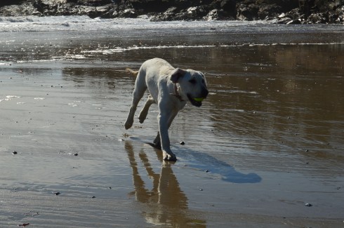
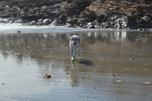
Magnolia Beach is a perfect for dogs and humans. Gigi had fun playing catch.
The sea shells on the beach are very unique.
This house on the hill above the beach must have some great views.
One of the beach goers took advantage of the windy conditions to fly his or her kite.
Attached below is a video of the sights and sounds of the beach during my visit.
How could you not want to visit an area with the name “by the sea” in its name? It sounds like the name of an idyllic setting from a novel. And the town lives up to that description. I passed by several fruit, vegetable and flower stands as well as signs to watch out for people riding horses. The houses and town also had a very Norman Rockwell feel.
I wasn’t sure how the footing and appearance of the park would be given the recent snowy weather and icy conditions on many of the trails at other parks. As it turned out, most of the ice and snow on the trails had melted and I only had to manage some small patches of ice and mud from the melted snow.
The trails are clearly marked and easy to walk. There are no steep inclines and the paths are wide enough to accommodate the throng of visitors.
There are a few trails that meander slightly off the trail. But one trail simply leads to the street and is behind a bunch of cattails so you really can’t view much of the pond. The other stupid trail goes to a thorny, rocky dead end.
As you walk on the main trail, you will pass Clarke Pond on your left. It was partially frozen and there were some ducks and geese milling around. I also got a few shots off them dunking for lunch. The gulls in the first photo looked like big blocks of snow at first glance. I especially like how the mom and dad duck kept the baby duckling close to them.
This slideshow requires JavaScript.
There were many breath taking views of the pond. I especially like how the frozen parts of the pond break with the unfrozen sections.
This slideshow requires JavaScript.
To the right of the main trail, I found a side road with a pond that channels into Clarke Pond. There were a variety of ducks and geese in this pond.
This slideshow requires JavaScript.
I met a lot of friendly and cool people at Coolidge. Shapoo was one of the cool and friendly folks I met (the name is a mix of shih tzu and poodle) .
Much to my consternation, I was unable to find the Ocean Lawn which offers views of the Boston skyline and Cape Cod as well as scenic views of the water. I totally missed the boat on that one as there are some great views and opportunities for some great shots from there. But, to the left of the trail, Magnolia Beach more than made up for it which I will post about very soon…click here to read about my visit to Magnolia Beach.