Parking: There is not a designated parking lot for Wilcox Park. But, you should be able to find off street parking.
Wilcox Park is not your average park. In fact, it is unique in many different ways. One thing that makes Wilcox Park unique is that it is not part of the DCR or any other city or governmental body. Wilcox Park is privately operated by the Westerly Public Library’s Board of Trustees. The library, located on the grounds of the park, and a group of volunteers help keep the grounds clean and orderly. They rely on donations and fundraisers.
Westerly Library is attached to the park at the entrance. The library’s beautiful architecture of the building is both artful yet modest. It complements the beauty of the park and seems right in place. There are also benches for visitors to unwind and perhaps read a book from the library’s collection.
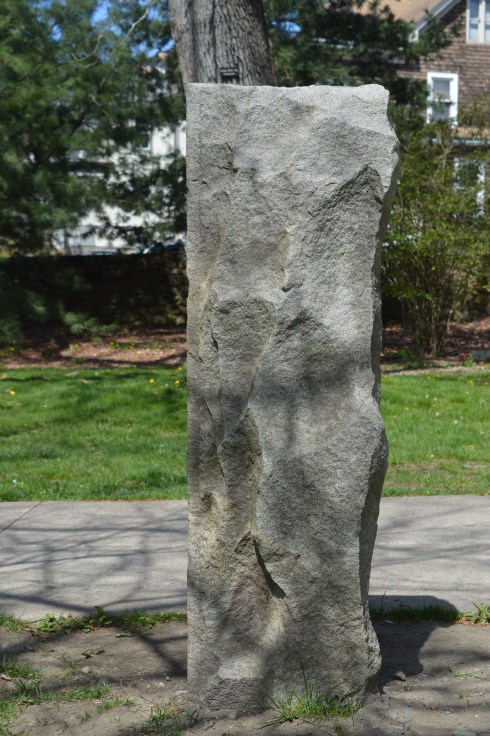
There are also a number of statues in the grounds of the library.
As you entered the park, one of the first statues you will see is the statue of Christopher Columbus sculpted by Ciriaco (or “Charles” as he was commonly known as) Pizzano in 1949. Originally from Avellino, Italy, Pizzano was living in Medford, Massachusetts, when he decided to sculpt this statue, appropriately, out of Westerly granite.
The inscription reads:
CRISTOFORO COLOMBO
INTREPID ITALIAN EXPLORER
WHO LINKED THE OLD WORLD OF
OUR FATHERS TO THE NEW WORLD
OF OUR SONS
On the back of the pedestal:
DEDICATED
BY
THE CITIZENS
OF
WESTERLY AND PAWCATUCK
A.D. 1949
Somewhere Leif Erikson is rolling around in his grave.
Down the staircase from the entrance to the park is a fountain (which was not running when I went to visit due to the still cold temperatures). The Wilcox Memorial Fountain was designed by John Francis Paramino in 1898 and was dedicated in honor of Harriet and Stephen Wilcox who had donated the land for the park.
There are a variety of beautiful trees, plants, bridges and statues at Wilcox Park.
This slideshow requires JavaScript.
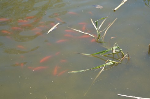
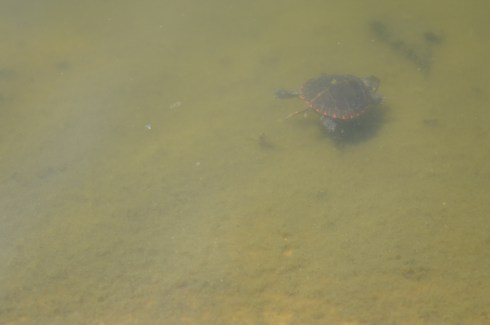
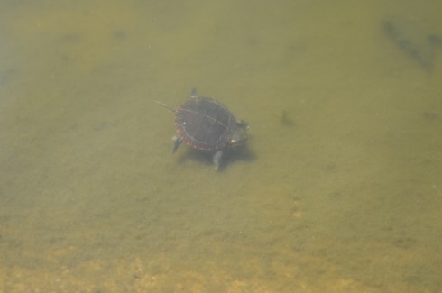
There is also a pond along the trails at Wilcox Park. It is populated with Koi fish
ducks
There’s room for two on this thing, right?
and baby turtles. I couldn’t find his mommy but I am sure she was nearby.
and rabbits
The bronze Runaway Bunny statue was dedicated in 1998 by Connecticut sculptor Joan Binney Ross. it is based on the book of the same name by Margaret Wise Brown. Unfortunately, the bunny has been the target of vandalism, predictably. But, it has been restored after each attack. Cameras are now installed liberally around the park to deter vandalism or catch the vandals.
This fella just wanted to play with the ducks
This sculpture sort of looked like a face to me. A very ugly face.
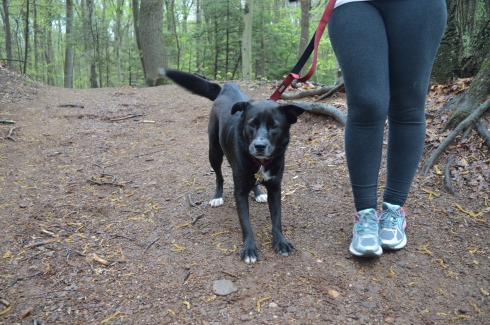
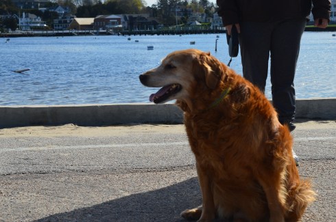
Dogs are allowed at Wilcox Park. Bandit, a Siberian Husky, had fun playing in the park. Apparently, Bandit earned his nickname because he “takes things”. What a beautiful dog. He caught my eye because of his handsome markings and his very cute smile. You can tell he’s a “bandit” based on his playful grin.
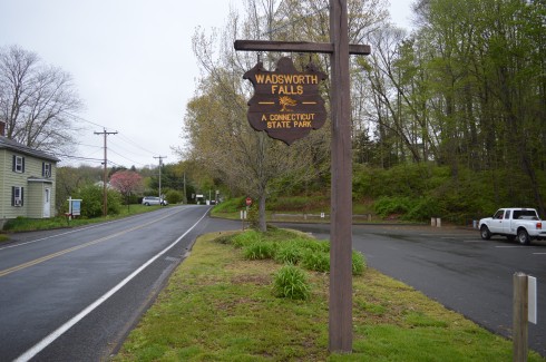
Location: 701 Wadsworth St, Middletown, CT or Cherry Hill Rd, Middlefield, CT
Cost: When I went to visit, it was free. I think they begin charging a fee starting Memorial Day weekend. There is no fee entrance fee during the weekdays. It costs CT residents $9 and it costs non Connecticut residents $15 to get in to the park during the weekend. You also may be able to access the park for free at the Cherry Hill Rd entrance.
Hours: Open everyday from sunrise until night time.
Parking: There are about 30 parking spots at the main entrance at Wadsworth St and another 20 or so at the Cherry Hill Rd entrance in Middlefield (pictured below)
We entered at the main entrance on Wadsworth St. There is a sandy beach area (there is a lifeguard on duty during the summer season). Since it was an overcast and chilly day, there weren’t any people swimming but there were a lot of birds congregating near the water.
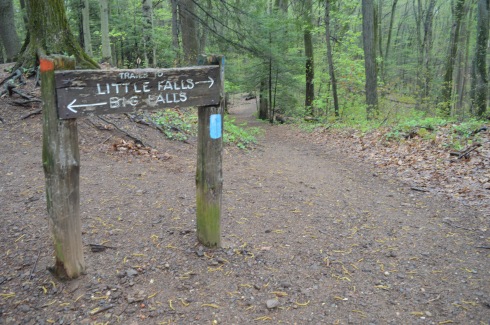
The highlight of the park, of course, are the falls. The two waterfalls at Wadsworth Falls are creatively named “Little Falls” and “Big Falls.”
Once you get on the main trail, you will eventually see the sign for the falls (after about a 3/4 to one mile hike). From this sign, it is about a half mile hike to the Little Falls and a mile hike to Big Falls if you enter from the entrance on Wadsworth St. There are also lots of trails that branched off the main trail and would be fun to explore if you have the time.
You can avoid the longer hike by parking on Cherry Hill Rd. Big Falls is accessible from a short walk down a well defined path from the lot on Cherry Hill Rd. But, the parking lot at Cherry Hill Rd is smaller than the lot on Wadsworth St.
Little Falls is actually a pretty big fall, even if it isn’t the biggest one at the park. But, the height of this waterfall may actually surpass the height of Big Falls. The last few shots in the slideshow are from our trek back to the main parking lot. The falls seemed much less rapid on our way back and you can see the ledges of the falls better.
This slideshow requires JavaScript.
There are a few different ways to get to Big Falls, the main attraction. The safest, but longest way, is to follow the trail until you reach the edge of the park which filters onto Cherry Hill Rd. The park is a short walk on a sidewalk to the right. Or, you can cross the railroad tracks and follow trail along the tracks for quicker access. There really isn’t a defined trail but there is space to walk a safe distance from the tracks. The railroad is still in operation but we didn’t see any trains while we were there.
There are two places I photographed the waterfalls from but there are probably even more places to view the waterfalls. The first place is a little tricky to get to and potentially dangerous. There is a path that goes off the trail across the tracks and up to ta cliff that offers some decent views of the waterfall. I did take some photographs from there but I would bypass it and go to the parking area of the entrance on Cherry Hill Rd to get a safer, closer and less obstructed view of the waterfalls. The first two photos are from the cliff area the rest are views from the entrance to the park.
This slideshow requires JavaScript.
From the main entrance on Wadsworth St it is about 1.5 mile hike to the falls and it is a 3.4 mile trail loop to walk the entire park. There were bicyclists, walkers and other photographers along the trail. Because of the inclines and, in some areas, rocky terrain, it would be a challenging place to go for a run. I would describe the trails as being easy to slightly moderate because of the inclines and rocky trails.
There are also pretty trees, bridges, plants, brooks and streams along the trails.
This slideshow requires JavaScript.
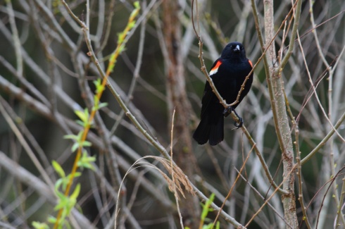
There was a lot of bird activity at Wadsworth Falls such as this male red-winged blackbird.
There are a variety of bird life at Wadsworth including bats. This is a bat house. It was built and maintained as part of an Eagle Scout project to help restore the bat population. It was good to see that it’s not only the cute animals that are being helped.
Toads and other amphibious life is also abundant at Wadsworth State Park. It was still pretty cold out so these toads seemed out of sorts. We gently picked them up and tried to find a warmer place for them under some leaves.
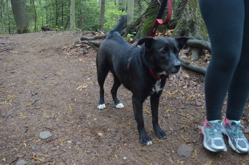
Leashed dogs are allowed at Wadsworth State Park. It is a great place for dogs to play and roam around. Caesaris (pronounced Kay-sar-is), a friendly 1 year old female Labrador and Australian Sheep Dog, enjoyed the unseasonably cool weather with his mom.
Below are some videos I took of the falls. The power, crispness and sound is much more evident in the videos.
Parking: Vehicles are not allowed on Lighthouse Rd, unless you area senior citizen or if you have a physical impairment which may prevent you from walking or biking or running down.
The jewel of Westerly, Rhode island, Watch Hill Lighthouse is a stone’s throw away from Napatree Conservation Point. The walk down Lighthouse Rd is about half a mile and the views are worth the walk. Watch Hill is a swanky village in the town of Westerly that offers views of the southern most coast of the state (besides Block Island).
To get a sense of just how beautiful the area is, this is the view from someone’s driveway. Not a bad view to wake up to every morning.
There are more stunning views as you walk down the road.
This slideshow requires JavaScript.
There is also a “cliff walk” along the road which is basically a walkway along the sidewalk which allows you to walk on a “cliff” type access way next to the road. Besides being a fun way to travel, the cliff walk also offers some beautiful views.
Since it is somewhat isolated and not too active this time of the year, birds tend to congregate at Watch Hill. I found a few Double Crested Cormorants.
Watch Hill Lighthouse is the second oldest lighthouse in Rhode Island (Beavertail Light is the oldest lighthouse in RI). Originally built in 1808, Watch Hill Lighthouse has been destroyed or damaged by various storms over the years. The current lighthouse that stands there was built in 1856. It was automated in 1986 and it is still active today.
The best part of my trip to Watch Hill was watching the waves from the rocks. It is considered one of the more beautiful and romantic of Rhode Island (sans Newport). In fact, just before I arrived there I had missed a man proposing to a woman at the location. When I got there they were drinking champagne and cuddling as they watched the waves.
This slideshow requires JavaScript.
Cute little Louis (pronounced Louie) is a 3 year old toy poodle. I love how the wind blew his fur and ears back but he still wanted to see the lighthouse!
Below are two videos of the waves at Watch Hill to give a better sense of the power of the waves there (and this was just on a regular day)
Please connect with me and like my Facebook page to see extra photos and videos I don’t post on my blog!
Parking: Parking was a breeze in the early morning hours in April. I found off street parking with a 3 hour limit. There were several parking spaces available. This will change when the weather begins to warm up (at this rate, sometime in mid-August). One thing I found interesting and somewhat vexing is that according to signs, the parking lot next to Napatree is not supposed to be used for going to the beach. I assume the parking is meant for shoppers and people patronizing the restaurants in the area. For an area that has limited parking this seems highly unusual. If you go in the summer, be aware parking will be very limited.
First, I’d like to thank everyone for reading and being so supportive as I post my 100th blog post. One hundred posts in just under one year. What better place to write about than Napatree!
A peninsula-like shaped area, Napatree is actually a sandy spit. It has been shaped through a process called longshore drift which is basically a process by which sediments such as clay, silt, sand and shingle are transported along the coast creating its unique shape.
You wouldn’t know it by looking at it now but Napatree used to be densely wooded. Trees lined the area until the Great September Gale of 1815 hit the area and the trees were destroyed. In fact, the name Napatree comes from the term nap or nape of trees.
The views from the entrance of Napatree are beautiful. In some of the photos, you can see a brown tint to the otherwise deep blue water. In fact, the colors seemed to change depending on where and when I took the photos. The tides, shallowness of the water and other factors can affect the way the water looks. I had never noticed it as distinctly as I did at Napatree. The waves and movement of the water may have played a part as well. Despite how calm the water seems in these photos this was not the case everywhere at Napatree.
This slideshow requires JavaScript.
If you look close, you can see the Amtrak train in the distance that services the Westerly area in one of the photos.
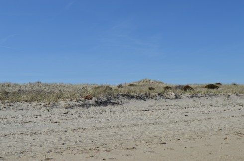
The dunes and the sand were also very pretty.
At first glance, Napatree seems like a long stretch of beach on only one side. But, I kept hearing noises over the dune. At first, I brushed it off as traffic or some other noise. Eventually, curiosity got the better of me and I decided to climb one of the dunes and check it out. What I found was pure paradise.
The calm waves and plain waterscape were replaced with crashing waves, foamy water, beautiful homes (the homes on both sides weren’t pretty shabby actually), the Watch Hill Lighthouse and marine activity.
This slideshow requires JavaScript.
When I arrived, the village was pretty desolate. This was partly due to the early time of the morning that I arrived and partly because the vacation season hasn’t began yet. Westerly did have a Cape Cod feel to it. From the quaint shops, the folksy, slowed down pace, the beautiful beaches and the mansions that dot the landscape (blog to follow soon about one of those lighthouses), I couldn’t help but think back to my childhood vacations at the Cape.
In due time, these empty streets will be bustling with activity. But, for now, it is a tourist/photographer’s dream having the area to one self!
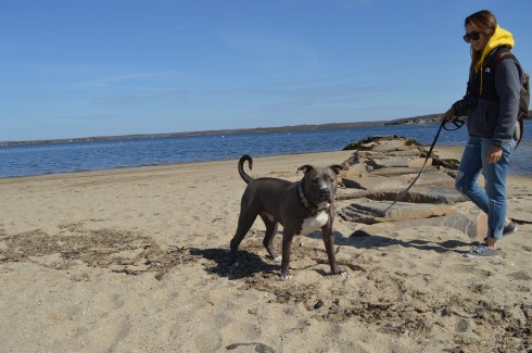
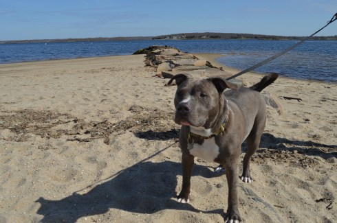
There were several dogs at Napatree during my visit. Dogs are allowed on the beach but only until May 2nd. So, you’ll have to wait until next year to take Fido!
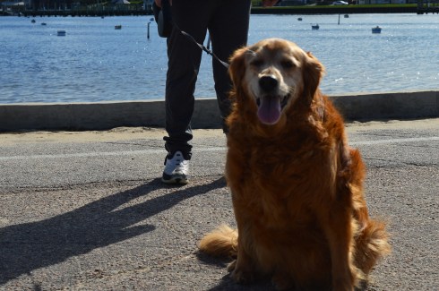
Daisy is a beautiful Golden Retriever. What a gorgeous smile.
Caesar is an aquatic pitbull
Below are videos of the different sides of Napatree. The first video is of the more calm waters that I saw when I first arrived. The second video is from the other side over the dunes to the more active side of Napatree.
Parking: There are about a half dozen parking spots on the side of the road across from the bridge on Lilac Lane (a very busy road so be careful parking and crossing there). There is also additional parking on side streets and farther along the road on Lilac Lane.
There are many bridges in New England. But, only few have the name, reputation and appearance of a bridge that could collapse any moment. The Wiggly Bridge is a mini-suspension bridge built in the 1930’s which crosses over a tidal flow from Barrel Mill Pond to the York River. If you’re not careful, you may end up in the York River!
Ok, Wiggly Bridge really isn’t that dangerous. But, it can give you the willies as you walk across it. Even though it is safe to walk across, the bridge does wiggle and make noises as you traverse it. I made it across the bridge without much trouble and took some photos of the bridge as I made my way across.
The short walk across the bridge leads to Steedman Woods, a tiny peninsula with a mile long loop. Dogs are allowed on the beach and on Steedman Woods. The vieews from the island and bridge are stunning.
This slideshow requires JavaScript.
Wiggly Bridge is also within walking distance, or a short drive from York Harbor. So, you can take in both of these cool attractions in one day.
Cooper is a 7 year old rescue dog and a resident of Maine. He also likes the bridge.
The videos below shows how unstable the bridge seems when you’re walking on it.
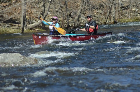
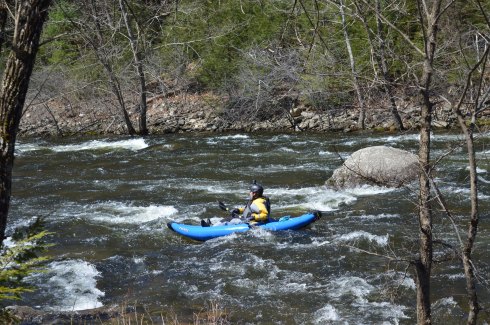
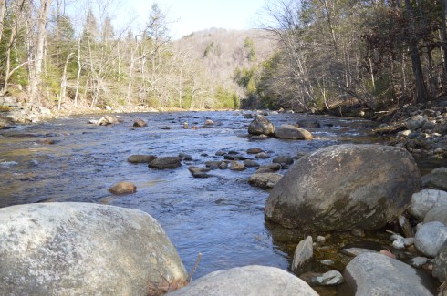
Each year hundreds of kayak and canoe racers come to the Western Massachusetts to test their mettle against the rapids of the Westfield River.
The Westfield River, one of the longer rivers in Western Massachusetts, runs 78.1 miles and has a 497 square miles drainage area consisting of several tributaries. It attracts enthusiasts, recreational competitors and people who just like to challenge themselves. It also attracts an array of boating fans.
The Westfield River Whitewater Races, which have been held every year since 1953, are the oldest consecutively run canoe races in the US. People come from all over New England and farther to participate in the races. The races consist of novice and expert divisions. The novices race lasts 8 miles and the experts race for 12 miles. The participants race in two person canoes or one person kayaks. As if the rapids weren’t challenging enough, the race officials have the water behind the dam held for three days before the race to give more momentum to the current.
I never knew how popular kayaking, canoeing and boating was in Western Massachusetts. It was hard enough to find a good place to pull over or park along the route of the race. I was able to find a place on the side of the road to catch some of the novices who had already started.
Since the river wasn’t very active here, we drove to the Knightville Dam, the launch point for the race. The area was very pretty and the river was more active here. I even caught some enthusiasts who weren’t participating in the race.
At the main parking area, one of the racers let me photograph his boat.
Still not happy with my location, I found a better spot along the side of the river past a precarious rocky decline. Watching the racers expressions was fascinating. Some were determined. Others looked focused and even a bit bewildered. Others just looked like they were having a grand time. Then, there were others who didn’t seem to be having fun at all.
This slideshow requires JavaScript.
Not every racer made it to the end.
Eventually, they were able to wade across the river to the other side, no easy task given the strength of the rapids.
Monty, an 8 year old Siberian Husky, came along to watch the race.
Below is a video of a canoe racing tandem fighting the rapids. You can hear the strength of the tide. Rumor has it that it gets even rougher farther down the river.
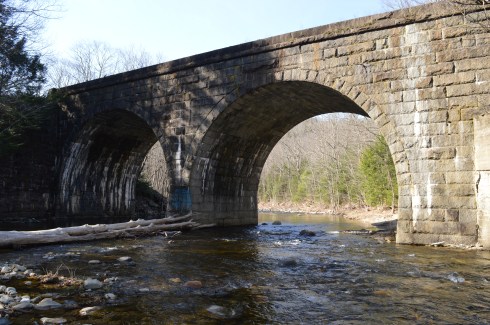
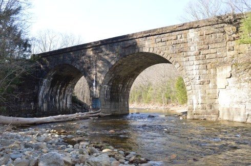
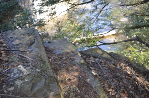
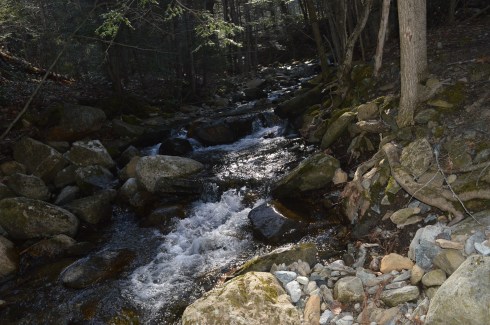
The Keystone Arches Bridge Trail is full of surprises. One of these surprises is a waterfall which is only a short jaunt down the main trail (about quarter of a mile from the entrance).
This slideshow requires JavaScript.
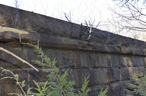
Another short walk brings you to the main attraction, the Keystone Arch Bridge.
The bridge was made from local Chester blue granite and reach up to 70 feet. There is a weathered, crumbling stairway up the side of the bridge. Bear in mind, the stairs are a little tricky if you do take this route. I took this stairway as far as I could. The views were very pretty.
There is a train railroad that continues on to the bridge
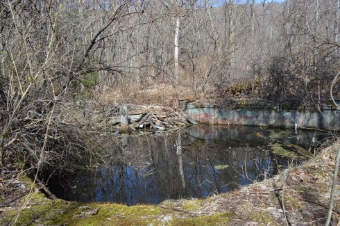
The Keystone Arches Bridge Trail encompasses area that used to be an artist colony. There are remnants of the colony present off the main trail
There was a clock tower
and the remnants of what used to be a swimming pool. Anyone want to take a quick dip?
and some other foundations of what were once buildings
Along the trail there are many pretty trees, plants, waterfalls and other interesting structures and rocks.
The Keystone Arches Bridge Trail boasts a variety of wildlife such as moose, bobcats, fox and a variety of other animals. I found this critter during my travels.
The 5 mile loop at Keystone Arches Bridge Trail are dirt trails with some jutting rocks and holes which often form puddles and dirt which must make it challenging for the cyclists who frequent the trail. The trails are easy to moderate with some challenging inclines. The website cautions the trail is not suitable for novice cyclists.
There are other arches and bridges at the Keystone Arches Bridge Trail and it is not unusual to see people climbing up some of the arches. However, we only went about a couple miles before turning back because of time constraints (see future blog post). The kayakers who frequent the stream at the Keystone Arches Trail, were absent due a white water race that particular day. But, normally they are present in large numbers.
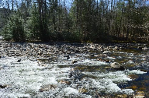
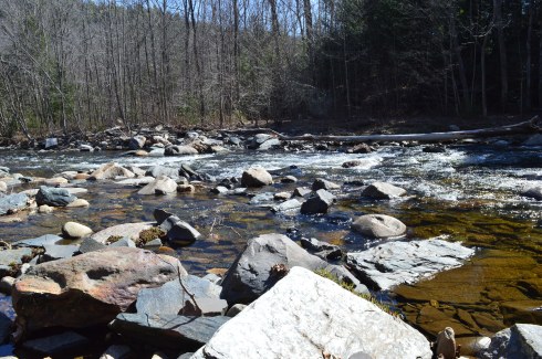
Along the trail are some impressive rapids.
I couldn’t help notice how the rapids mirror our own lives: rapid and frenzied activity one moment, calm, serene the next.
The video below gives a glimpse of the power, beauty and serenity of the rapids.
Durango, a 12 year old Australian Sheepdog, is the mascot of the Chester Railway Station And Museum and he’s a great tour guide. The Chester Railway Station Museum had organized a tour of the trail and Durango went along with them.
In 1900, Stephen Salisbury II built a tower on what is now known as Salisbury Park as a tribute to his friend, historian and jack of all trades, George Bancroft. And to think, my friends only usually give me gift cards, wine and books for my birthday.
The park is has a wide variety of bird life.
As I was reviewing the photos, I couldn’t help feeling the tower was purposefully constructed to look as though it was incomplete. The sides are not rounded and seem almost as though they were cut off from the facade or the builder gave up half way through. But, as the photos show it was indeed constructed this way by design.
This slideshow requires JavaScript.
My favorite view from the tower was at the arched entrance.
The 56 foot tower is made of natural stone and granite. It was designed by Stephen C. Earle and Clellann W. Fisher.
The plaque at the memorial states:
BANCROFT TOWER
THIS TOWER WAS BUILT IN 1900
TO HONOR THE MEMORY OF
GEORGE BANCROFT
1800-1891
BORN AT THE FOOT OF THIS HILL
HE ROSE TO THE POSTS OF
SECRETARY OF THE NAVY
FOUNDER OF THE U.S. NAVAL ACADEMY
ANNAPOLIS, MARYLAND
U.S. MINISTER TO GREAT BRITAIN
AND GERMANY
THIS MEMORIAL WAS BUILT BY HIS
FRIEND AND ADMIRER
STEPHEN SALISBURY III
Jacks wasn’t impressed by the tower.
There were some views of the city from the parking lot.
During my visit and in my research after the shoot, I found out they let visitors inside the tower during October of each year. The views at the top are said to give 360 degree views of the area. The sorority and fraternity at the local college also holds a Halloween party for the kids in the area at the tower with mild scares. So, it looks like a visit in October is on my list!
A walking tour of the Bancroft Tower:
Please stop by my Facebook page and like my page for extra photos, videos and other fun stuff!
Driving home from Balance Rock State Park, I happened upon Lake Onota This is what is so great about New England, and really any area of the country. You can find the most beautiful places at the most unexpected moments.
A popular fishing spot, Lake Onota is a 617 acre pond located in Pittsfield, Massachusetts. It flows into the Housatonic River which eventually drains into Long Island Sound. Fishermen and women and boaters flock to Lake Onota for the bass, trout, walleye and crappie (yes they even fish for crappie fish).
A roadway bisects the lake. Of course, typical of New England weather, while it was very cloudy on one side, the other side had nary a cloud.
This slideshow requires JavaScript.
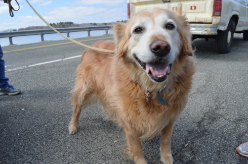
Dogs like Lake Onota as well. I met Becca, a happy 9 year old golden retriever,there.
Parking: There are several parking lots at the Greater Worcester Land Trust which the Cascading Waters is part of. The closest lot to the Cascading Waters is small with only room for about half a dozen cars. You can also drive up to Cascading Waters via Cataract St and park on the dirt road there.
One of the great things about Worcester (pronounced “Woo-stah”) is its diversity of people and places. One moment you could be in the heart of the city and only ten minutes later you could be at a grand waterfall. It remind me a lot of Boston in this regard.
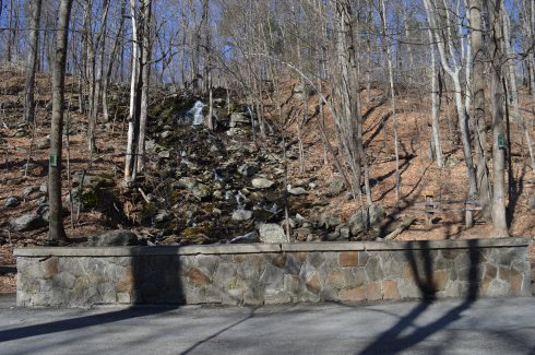
I found myself at one of the natural wonders of Worcester, Cascading Falls, Saturday.
Located about an hour west of Boston, Cascading Falls is known for its beauty and trails. There are both hiking and biking trails at the main parking area. I chose the most direct hiking route to the falls. The trail is pretty flat and straight with some pretty views. I also noticed some greenery sprouting on the eve of the first day of Spring. it’s about half a mile to the Cascading Waters from the parking area.
There is a trail to the right of the falls with a fairly steep incline. The trail leads to the top of the falls. You can go to the top of the waters. The views are pretty sweet.
This slideshow requires JavaScript.
There are also interesting rocks, pools of water and streams at the top of Cascading Waters.
This slideshow requires JavaScript.
Although the sun was out and the temperatures did increase, it was still relatively cold as this branch shows.
The waterfall leads to a stream just under and behind the trail.
Cascading Waters is a great place to take your dog for a walk. I met two golden retrievers; Wilson (on the left ) and Tucker, while I was there.
Below are two videos of Cascading Waters from the trail view and view from the top of the falls.