Hours: Open 24 hours a day, 365 days a year (may be closed on federal and/or state holidays)
It’s not very often that you are impressed with a visitor center. But the Guilford Welcome Center is no ordinary welcome center.
It was a long drive to Vermont and sometimes nature calls…
From the moment you walk into the Guilford (VT) Welcome Center, you know you’re not in your average welcome center. I also love how they call it a “welcome center” and not a “visitor center”. it’s just another example of the folksy and friendly nature of Vermont. The tables, chairs and fireplace give the welcome center a homey feel. You could spend hours sitting at their wooden tables with a good book and a cup of coffee while the snow falls outside.
The backside of the welcome center has an area to sit and take in the beautiful Vermont landscapes. There is also an exhibit of old farm equipment.
There are also a variety of trinkets and crafts located throughout the welcome center.
As I did my research on the Vermont Welcome Center, I noticed the welcome center in Guilford is not the only visitor center with attractions and other interesting things. There is a Vietnam War Memorial listing all the residents from Vermont who died while serving in that war. The Bennington, VT, welcome center has a “singing drum”. Each welcome center seems to have its own unique flavor and entertainment. They definitely do not make visitor centers like this in Massachusetts. That’s for sure.
There are more exhibits and areas to sit in the front of the welcome center.
This slideshow requires JavaScript.
The Guilford Welcome Center also has a dog park area across from the center. Duncan, a 3 and a half year old Cavalier King, stopped by for a quick pit stop.
Duncan’s sister, Vera, an 18 month old Cavalier King Spaniel, also took a moment to pose for me.
Parking: There is a lot that can accommodate about 30 or so cars behind the waterfall off Meridian St (a side road off Deerfield St where the bridge is) or you can park in one of the lots of the local establishments and walk to the park, after patronizing them of course. You can’t park on Deerfield St.
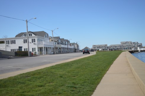
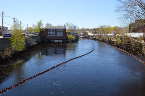
It’s not often that you see a silver fish on a pole while you’re driving down the main streets of a busy suburb. So, when I saw Brookie, the mascot of River Works Park, I had to stop and check it out.
The River Works Park is a quiet place (if you can ignore the passing traffic on Deerfield Rd) where residents and visitors can sit on the benches or walk along the sidewalk or bridge and admire the Green River below.
For a roadside attraction, the River Works Park is full of surprises and beauty. One of these surprises is the walk way along the sidewalk that is blocked off by a fence. Of course, there was an opening in the wire fence. The views from the walk way weren’t so great though and I only managed to get a few scratches when I walked along it.
The walkway, which was dedicated in November of 1999, has several memorials and plaques along the sidewalk. This bench was dedicated to Barbara Tillmanns, Greenfield’s “#1 cheerleader.” Tillmanns was a town councilor for Greenfield and very active in the community. She passed away in 2014 at the age of 72. One of her endeavors was to begin an initiative to establish a series of commemorative benches throughout Greenfield. Here’s one:
A sign remains where the J. Russell Co once stood. The company made Green River Knives. Greenfield Tap & Die also stood there once upon a time. The J. Russell Co and Greenfield Tap & Die were the main employers of the area for much of the 1800’s and the J. Russell Co made the highly touted Green River Knife.
If you look closely at Brookie, the mascot of River Works Park, you can see the forks, spoons, cutlery and other utensils collected from the residents of Greenfield and Franklin County that make up the shape of the fish as a tribute to the J. Russell Cutlery Co. (you may have to zoom into the photo).
The aptly named Green River, runs through the park. There were some modest waves and ripples in the river. The reason for this will soon be evident.
I thought made for a pretty backdrop.
However, just beyond the bridge, we found this pretty waterfall.
This slideshow requires JavaScript.
There is no sidewalk on the side of the road where the best views of the waterfalls are so I had to keep the video short since I shot it during a red light.
There is a lot of interesting historical information about the J. Russell Co and the area which you can access in the links below
Parking: There are about half a dozen parking spots next to the tower and they fill up quickly.(and they were all filled at 8 o’clock on a Friday morning). There is also parking at the gate of the entrance on Mountain Road for about another half a dozen vehicles. The walk to the tower from the main entrance is about a mile.
Cost: Free
Hours: Open 365 days a year from sunrise to sunset
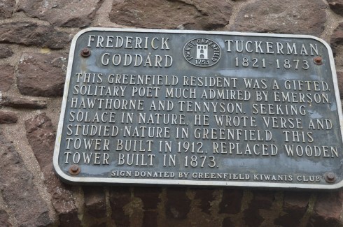
Perhaps it’s the unobstructed, sweeping views of the landscapes or maybe it’s the solitude of being in such an isolated tall structure. Whatever the reason, poets seemed to flock to this observation tower. It has since been known as the “poets seat tower” because of the long tradition of poets that have been attracted to the location. Frederick Goddard Tuckerman, a local poet at the time, is credited with bestowing this name on the structure in 1850. The tower, which was built in 1912, now attracts people of all walks of life, not just poets. Prior to the construction of the sandstone tower, a wooden observation tower had been built on the edge of the lookout in 1879. A plaque at the tower acknowledges Tuckerman’s role in the history of the tower.
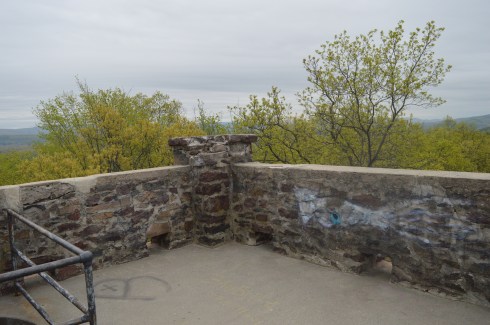
Even before you reach the top of the tower, if you dare, there are some impressive views of the Greenfield (MA), Connecticut, Deerfield (MA) and Green River valleys. The ledge of the road where the tower is bult has a rocky ledge from where you can get some views of the Greenfield area below. It’s a long way down!
The highest point of Greenfield, the tower is 4 floors (counting the ground floor and top floor). The views from each floor are pretty stunning. After all the rain in the area, the greens were very vivid.
This slideshow requires JavaScript.
As I stood looking over the land below I couldn’t help but think of how the landscape has changed over the years. Many years ago people looked over farmlands and valleys. Now, we look over schools, houses, parks and businesses. I also thought about all of the people who came here to rid their mind and soul of their worries by taking in the beautiful views. It really can make you take a step back (and hopefully not forward) when you’re up so high and appreciating the nature around us.
The journey to the top is not difficult. A trip up one stairwell and one spiral staircase take you to the top.
The arches and architecture of the tower rival the beauty of the views from the top of the tower.
This slideshow requires JavaScript.
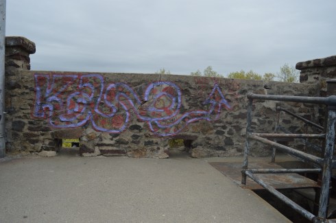
And what would a historic structure be without graffiti? As seems to be customary, particularly in Western Mass, there was graffiti on the walls of the sandstone structure. It did seem fitting that poetry lined the walls of “Poet’s Seat Tower”
“Jump off the cliff and build your wings on the way down”
The are also benches along the road to the tower which offer views of the area. There are also hiking trails that branch off from the road to the tower. The trails look easy to moderate but I could not walk on them because of time constraints. I did hear a lot of presumably animal activity in the woods.
Below is a video of the view from the top of Poet’s Seat Tower
If there is one thing Vermont and New Hampshire are known for, besides moose and lakes, it has to be covered bridges. But, of the 164 covered bridges listed for Vermont and New Hampshire one stands alone.
The Windsor-Cornish Bridge (or Cornish-Windsor if you like) is the longest covered bridge in all of New England. At 449 ft and 5 inches, the Windsor-Cornish Bridge is not only the longest covered bridge in New England it is the second longest wooden covered bridge in the entire United States just behind the Smolen-Gulf Bridge in Ohio (613 ft) which opened in 2008. It is, however, the longest wooden covered bridge as well as the longest two span covered bridge in the United States.
The bridge was originally framed at a nearby meadow northwest of the site and later moved to its proper location. As an aside, I didn’t see anyone cross it on a horse. But, if they did, they had better walk it across or be ready to pay their two bits.
It has been through three constructions and repairs due to being transported from another location and after being repaired due to flood damage and ice in 1977. In July, 1987, the bridge was closed to traffic due to deterioration and reconstructed in 1989. The bridge is listed on the National Register of Historic Places.
The Windsor-Cornish Bridge holds another unique distinction. It is one of the few bridges that used to be a toll bridge but no longer has a toll (usually it works the other way around in new England). The bridge was purchased by the state in 1936 and operated it as a toll bridge until June 1, 1943. The bridge does have two lane traffic but pedestrians traffic is not allowed.
The Windsor-Cornish Bridge is one resilient bridge. Previously, there have been three bridges built on this site in 1796, 1824 and 1828. All of these bridges were destroyed by floods. For now, though, the bridge still stands proudly.
The videos below show what driving through the tunnel (both ways) feels like.
Cost: I paid $15 (the weekday fee) to get in (I went on a Saturday). But, the prices on their web site show the cost as being $13 for CT residents and $22 for non CT residents on weekends and holidays (it’s worth every penny) and $9 for CT residents and $15 for non CT residents. Also, if you enter at 4 or later it costs $6 for CT residents and $6 for non CT residents to enter the park (bear in mind the park’s gates close at 8 pm when it is in season). There are also additional fees for camping there.
One workaround to paying a fee is to park at 1288 Boston Post Road instead of driving down the access road to the payment booths and walk (almost 2 miles) to the beach. I would recommend this option when it is nice out or if you are bicycling. However, since the park is so big it may be hard to see everything on foot. So, riding your bike from 1288 Boston post Road may be a best option.
Hours: The beach is still accessible, by foot or bike, in the off season without any staff.
Connecticut’s largest public beach, Hammonasset Beach is split into different areas for camping and for people who want to visit the more than 2 miles of beach.
Meaning “where we dig holes in the ground”, Hammonasset is actually part of Long Island Sound.
The campground at Hammonasset has 556 campsites and 8 rustic cabins for reservation during camping season which runs from mid-May until October 8. Hammonasset also has a nature center at Meigs Point and acres of wetlands.
After paying the entrance fee, we asked the helpful woman at the booth where the best place to go for photography is and she suggested Meigs Point.
Meigs Point runs along the shoreline of the beach. There are lots of ducks, birds and lots of other wildlife on the beach and on the trails behind the beach.
This slideshow requires JavaScript.
The beach has some pretty views. There are also restrooms with showers and changing rooms at Meigs Point if you decide to go for a swim. During my visit it was overcast and chilly. The lack of sun didn’t take away from the beauty of the beach.
This slideshow requires JavaScript.
There is also a jetty. It went out quite a way. Since the rocks were pretty slippery, I made it about half way out before turning back.
Hammonasset is a beautiful beach, although it can get crowded as many beaches do during the summer months. If you live nearby it may be best to get a seasonal pass rather than paying the somewhat hefty fee each time you visit.
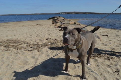
Leashed dogs are allowed on the beach during the off season (from November until April). They are still allowed on the trails but not on the beach from April until the end of October.
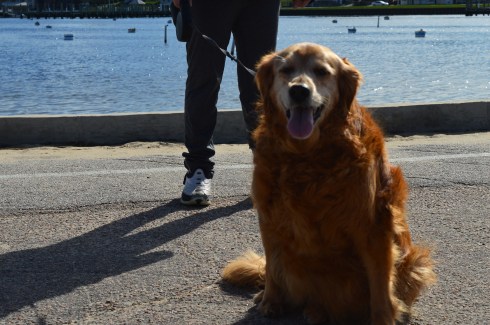
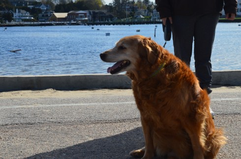
I met Summer, a golden retriever, on the trail Meigs Point. Especially after this unseasonably cold winter, we all could use a little more summer in our lives!
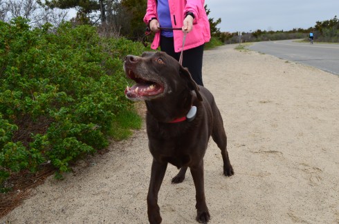
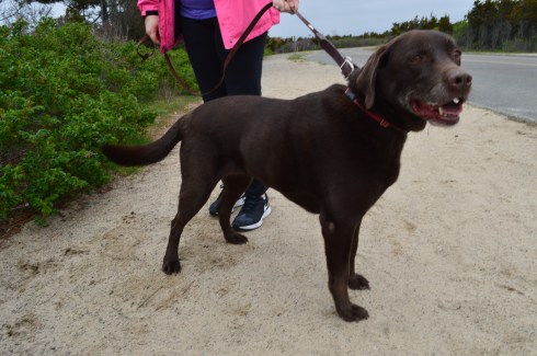
Jessie, a chocolate Labrador, had a great time on the trail.
Parking: There is not a designated parking lot for Wilcox Park. But, you should be able to find off street parking.
Wilcox Park is not your average park. In fact, it is unique in many different ways. One thing that makes Wilcox Park unique is that it is not part of the DCR or any other city or governmental body. Wilcox Park is privately operated by the Westerly Public Library’s Board of Trustees. The library, located on the grounds of the park, and a group of volunteers help keep the grounds clean and orderly. They rely on donations and fundraisers.
Westerly Library is attached to the park at the entrance. The library’s beautiful architecture of the building is both artful yet modest. It complements the beauty of the park and seems right in place. There are also benches for visitors to unwind and perhaps read a book from the library’s collection.
There are also a number of statues in the grounds of the library.
As you entered the park, one of the first statues you will see is the statue of Christopher Columbus sculpted by Ciriaco (or “Charles” as he was commonly known as) Pizzano in 1949. Originally from Avellino, Italy, Pizzano was living in Medford, Massachusetts, when he decided to sculpt this statue, appropriately, out of Westerly granite.
The inscription reads:
CRISTOFORO COLOMBO
INTREPID ITALIAN EXPLORER
WHO LINKED THE OLD WORLD OF
OUR FATHERS TO THE NEW WORLD
OF OUR SONS
On the back of the pedestal:
DEDICATED
BY
THE CITIZENS
OF
WESTERLY AND PAWCATUCK
A.D. 1949
Somewhere Leif Erikson is rolling around in his grave.
Down the staircase from the entrance to the park is a fountain (which was not running when I went to visit due to the still cold temperatures). The Wilcox Memorial Fountain was designed by John Francis Paramino in 1898 and was dedicated in honor of Harriet and Stephen Wilcox who had donated the land for the park.
There are a variety of beautiful trees, plants, bridges and statues at Wilcox Park.
This slideshow requires JavaScript.
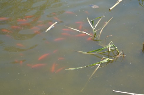
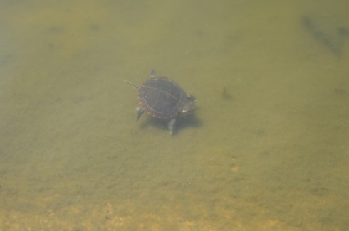
There is also a pond along the trails at Wilcox Park. It is populated with Koi fish
ducks
There’s room for two on this thing, right?
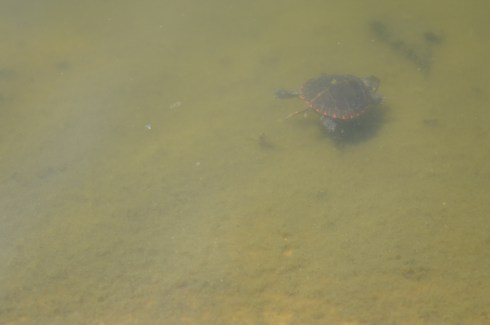
and baby turtles. I couldn’t find his mommy but I am sure she was nearby.
and rabbits
The bronze Runaway Bunny statue was dedicated in 1998 by Connecticut sculptor Joan Binney Ross. it is based on the book of the same name by Margaret Wise Brown. Unfortunately, the bunny has been the target of vandalism, predictably. But, it has been restored after each attack. Cameras are now installed liberally around the park to deter vandalism or catch the vandals.
This fella just wanted to play with the ducks
This sculpture sort of looked like a face to me. A very ugly face.
Dogs are allowed at Wilcox Park. Bandit, a Siberian Husky, had fun playing in the park. Apparently, Bandit earned his nickname because he “takes things”. What a beautiful dog. He caught my eye because of his handsome markings and his very cute smile. You can tell he’s a “bandit” based on his playful grin.
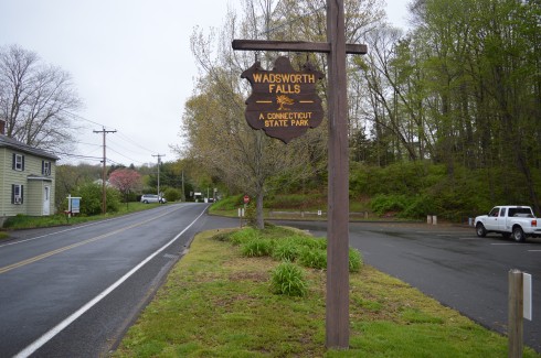
Location: 701 Wadsworth St, Middletown, CT or Cherry Hill Rd, Middlefield, CT
Cost: When I went to visit, it was free. I think they begin charging a fee starting Memorial Day weekend. There is no fee entrance fee during the weekdays. It costs CT residents $9 and it costs non Connecticut residents $15 to get in to the park during the weekend. You also may be able to access the park for free at the Cherry Hill Rd entrance.
Hours: Open everyday from sunrise until night time.
Parking: There are about 30 parking spots at the main entrance at Wadsworth St and another 20 or so at the Cherry Hill Rd entrance in Middlefield (pictured below)
We entered at the main entrance on Wadsworth St. There is a sandy beach area (there is a lifeguard on duty during the summer season). Since it was an overcast and chilly day, there weren’t any people swimming but there were a lot of birds congregating near the water.
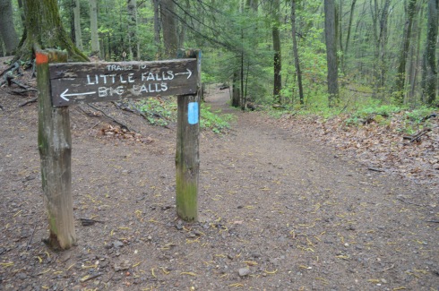
The highlight of the park, of course, are the falls. The two waterfalls at Wadsworth Falls are creatively named “Little Falls” and “Big Falls.”
Once you get on the main trail, you will eventually see the sign for the falls (after about a 3/4 to one mile hike). From this sign, it is about a half mile hike to the Little Falls and a mile hike to Big Falls if you enter from the entrance on Wadsworth St. There are also lots of trails that branched off the main trail and would be fun to explore if you have the time.
You can avoid the longer hike by parking on Cherry Hill Rd. Big Falls is accessible from a short walk down a well defined path from the lot on Cherry Hill Rd. But, the parking lot at Cherry Hill Rd is smaller than the lot on Wadsworth St.
Little Falls is actually a pretty big fall, even if it isn’t the biggest one at the park. But, the height of this waterfall may actually surpass the height of Big Falls. The last few shots in the slideshow are from our trek back to the main parking lot. The falls seemed much less rapid on our way back and you can see the ledges of the falls better.
This slideshow requires JavaScript.
There are a few different ways to get to Big Falls, the main attraction. The safest, but longest way, is to follow the trail until you reach the edge of the park which filters onto Cherry Hill Rd. The park is a short walk on a sidewalk to the right. Or, you can cross the railroad tracks and follow trail along the tracks for quicker access. There really isn’t a defined trail but there is space to walk a safe distance from the tracks. The railroad is still in operation but we didn’t see any trains while we were there.
There are two places I photographed the waterfalls from but there are probably even more places to view the waterfalls. The first place is a little tricky to get to and potentially dangerous. There is a path that goes off the trail across the tracks and up to ta cliff that offers some decent views of the waterfall. I did take some photographs from there but I would bypass it and go to the parking area of the entrance on Cherry Hill Rd to get a safer, closer and less obstructed view of the waterfalls. The first two photos are from the cliff area the rest are views from the entrance to the park.
This slideshow requires JavaScript.
From the main entrance on Wadsworth St it is about 1.5 mile hike to the falls and it is a 3.4 mile trail loop to walk the entire park. There were bicyclists, walkers and other photographers along the trail. Because of the inclines and, in some areas, rocky terrain, it would be a challenging place to go for a run. I would describe the trails as being easy to slightly moderate because of the inclines and rocky trails.
There are also pretty trees, bridges, plants, brooks and streams along the trails.
This slideshow requires JavaScript.
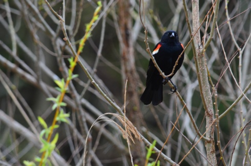
There was a lot of bird activity at Wadsworth Falls such as this male red-winged blackbird.
There are a variety of bird life at Wadsworth including bats. This is a bat house. It was built and maintained as part of an Eagle Scout project to help restore the bat population. It was good to see that it’s not only the cute animals that are being helped.
Toads and other amphibious life is also abundant at Wadsworth State Park. It was still pretty cold out so these toads seemed out of sorts. We gently picked them up and tried to find a warmer place for them under some leaves.
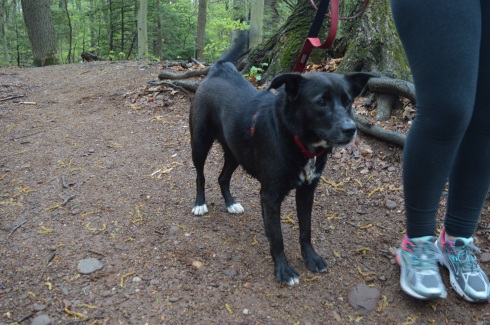
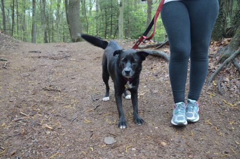
Leashed dogs are allowed at Wadsworth State Park. It is a great place for dogs to play and roam around. Caesaris (pronounced Kay-sar-is), a friendly 1 year old female Labrador and Australian Sheep Dog, enjoyed the unseasonably cool weather with his mom.
Below are some videos I took of the falls. The power, crispness and sound is much more evident in the videos.
Parking: Vehicles are not allowed on Lighthouse Rd, unless you area senior citizen or if you have a physical impairment which may prevent you from walking or biking or running down.
The jewel of Westerly, Rhode island, Watch Hill Lighthouse is a stone’s throw away from Napatree Conservation Point. The walk down Lighthouse Rd is about half a mile and the views are worth the walk. Watch Hill is a swanky village in the town of Westerly that offers views of the southern most coast of the state (besides Block Island).
To get a sense of just how beautiful the area is, this is the view from someone’s driveway. Not a bad view to wake up to every morning.
There are more stunning views as you walk down the road.
This slideshow requires JavaScript.
There is also a “cliff walk” along the road which is basically a walkway along the sidewalk which allows you to walk on a “cliff” type access way next to the road. Besides being a fun way to travel, the cliff walk also offers some beautiful views.
Since it is somewhat isolated and not too active this time of the year, birds tend to congregate at Watch Hill. I found a few Double Crested Cormorants.
Watch Hill Lighthouse is the second oldest lighthouse in Rhode Island (Beavertail Light is the oldest lighthouse in RI). Originally built in 1808, Watch Hill Lighthouse has been destroyed or damaged by various storms over the years. The current lighthouse that stands there was built in 1856. It was automated in 1986 and it is still active today.
The best part of my trip to Watch Hill was watching the waves from the rocks. It is considered one of the more beautiful and romantic of Rhode Island (sans Newport). In fact, just before I arrived there I had missed a man proposing to a woman at the location. When I got there they were drinking champagne and cuddling as they watched the waves.
This slideshow requires JavaScript.
Cute little Louis (pronounced Louie) is a 3 year old toy poodle. I love how the wind blew his fur and ears back but he still wanted to see the lighthouse!
Below are two videos of the waves at Watch Hill to give a better sense of the power of the waves there (and this was just on a regular day)
Please connect with me and like my Facebook page to see extra photos and videos I don’t post on my blog!
Parking: Parking was a breeze in the early morning hours in April. I found off street parking with a 3 hour limit. There were several parking spaces available. This will change when the weather begins to warm up (at this rate, sometime in mid-August). One thing I found interesting and somewhat vexing is that according to signs, the parking lot next to Napatree is not supposed to be used for going to the beach. I assume the parking is meant for shoppers and people patronizing the restaurants in the area. For an area that has limited parking this seems highly unusual. If you go in the summer, be aware parking will be very limited.
First, I’d like to thank everyone for reading and being so supportive as I post my 100th blog post. One hundred posts in just under one year. What better place to write about than Napatree!
A peninsula-like shaped area, Napatree is actually a sandy spit. It has been shaped through a process called longshore drift which is basically a process by which sediments such as clay, silt, sand and shingle are transported along the coast creating its unique shape.
You wouldn’t know it by looking at it now but Napatree used to be densely wooded. Trees lined the area until the Great September Gale of 1815 hit the area and the trees were destroyed. In fact, the name Napatree comes from the term nap or nape of trees.
The views from the entrance of Napatree are beautiful. In some of the photos, you can see a brown tint to the otherwise deep blue water. In fact, the colors seemed to change depending on where and when I took the photos. The tides, shallowness of the water and other factors can affect the way the water looks. I had never noticed it as distinctly as I did at Napatree. The waves and movement of the water may have played a part as well. Despite how calm the water seems in these photos this was not the case everywhere at Napatree.
This slideshow requires JavaScript.
If you look close, you can see the Amtrak train in the distance that services the Westerly area in one of the photos.
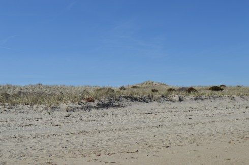
The dunes and the sand were also very pretty.
At first glance, Napatree seems like a long stretch of beach on only one side. But, I kept hearing noises over the dune. At first, I brushed it off as traffic or some other noise. Eventually, curiosity got the better of me and I decided to climb one of the dunes and check it out. What I found was pure paradise.
The calm waves and plain waterscape were replaced with crashing waves, foamy water, beautiful homes (the homes on both sides weren’t pretty shabby actually), the Watch Hill Lighthouse and marine activity.
This slideshow requires JavaScript.
When I arrived, the village was pretty desolate. This was partly due to the early time of the morning that I arrived and partly because the vacation season hasn’t began yet. Westerly did have a Cape Cod feel to it. From the quaint shops, the folksy, slowed down pace, the beautiful beaches and the mansions that dot the landscape (blog to follow soon about one of those lighthouses), I couldn’t help but think back to my childhood vacations at the Cape.
In due time, these empty streets will be bustling with activity. But, for now, it is a tourist/photographer’s dream having the area to one self!
There were several dogs at Napatree during my visit. Dogs are allowed on the beach but only until May 2nd. So, you’ll have to wait until next year to take Fido!
Daisy is a beautiful Golden Retriever. What a gorgeous smile.
Caesar is an aquatic pitbull
Below are videos of the different sides of Napatree. The first video is of the more calm waters that I saw when I first arrived. The second video is from the other side over the dunes to the more active side of Napatree.
Parking: Parking was very limited, especially with the huge turnout. I got there early so I was fortunate enough to snag a 3 hour parking spot near the event in the shopping area of the town.
Every year for the past 18 years, the Ocean Community Chamber of Commerce partners with several businesses and community members to raise money by dumping 20,000 ducks into the Pawcatuck River (don’t worry, they’re rubber ducks) and watching them race down the river. The event helps raise money for over 40 local schools and other non profit groups in the area.
Visitors to the duck race can buy “sponsor tickets” with a unique number of a duck for $5 a chance. Duck shaped whistles can also purchased, much to the delight of many spectators and parents. Vendors and a local radio station also sell items and entertain the visitors.
All 20,000 rubber ducks are dumped into the river from a bulldozer which has been filled with the toys prior to the race.
That’s a lot of ducks!
A short walk from the bridge, in Donahue Park, there are also fun stuff for kids (and even adults who feel young at heart) such as a bouncy house, face painting, balloon shaping and other activities. There also was a classic car, a ’47 Mac, owned by the parent of Bustah (one of the dogs below). Cool car.
There were ducks in the water and on land.
Before the race began, a duck, a real duck this time, decided to stop by and see what was going on.
Then, a family of ducks and ducklings swam by. I feel badly for the little one lagging behind in the last photo. I feel like that everyday.
This is the Pawcatuck River before the race.
This is the river with 20,000 ducks in it.
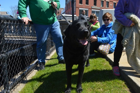
Even dogs came out to watch the race.
Bustah is an American Bulldog. Beautiful markings. I like how he is intently staring at his dad who is standing behind me to get his attention.
Reggie is a black Lab who is super friendly (but aren’t they all?)
Below is a video of the dunk dumping. As you can tell by the audio, the crowd was getting antsy and they really got into the whole countdown.