If you hear the faint sound of piano music along city sidewalks and parks, don’t be alarmed. You’re not imagining it and, despite it being close to Halloween, it’s not some ghastly theme introducing an apparition.
Since 2008, the international tour group, “Play Me, I’m Yours” has been leaving pianos in public spaces for all to enjoy. Part of street pianos and the brainchild of Luke Jerram, the “Play Me, I’m Yours” program has installed over 1,500 pianos in 50 cities worldwide. The pianos have been artistically decorated by local artists and neighborhood clubs. Many of the pianos, as you will see below, have artistic themes painted on then that are representative of the area they are located in.
With 60 pianos located throughout the city, you’re sure to find one in your travels if you do travel to the city. I was fortunate enough to see a few of these pianos. initially, my goal was to photograph all 60 pianos. But, since this is the final weekend they will be in Boston, I wanted to post about them before they are gone. Please note, some of the pianos are only out during certain hours, usually the same hours of the businesses they are located in front of. The pianos will be donated to neighborhood groups and youth groups after the program is over.
I noticed this piano (with some help from a co-worker) on the way to work. It is located on the boardwalk in front of the Children’s Museum (308 Congress St, Boston, MA). The buildings in the background provide the perfect backdrop.
Since it was close to my place of business in the city, I was able to visit this piano during my lunch break. It is a beautiful and actually a very peaceful area to relax, despite all of the construction and the busy street it is located off. It is located at Seaport Green by District Hall, South Boston.
To get a change of scenery, I decided to go into the busier sections of the city Thursday. This piano is located at the Massachusetts State House at Ashburton Park, Boston. It was great to see so many people of so many backgrounds using the pianos. The look of concentration on the pianists’ face below and the ease at which she plays is incredible.
The next piano I found was at Reader’s Park in front of a Walgreen’s, of all places, at 24 School St, Boston. I waited around for while to take some photos of the piano unoccupied but he played for a long while. But, I think it is awesome to see someone be so focused!
The last piano I visited is next to the Macy’s at 450 Washington St, Boston. Some people are camera shy.
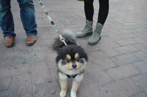
Even the dogs came out to see the pianos. Charley is a 3 year old Pomeranian with beautiful markings.
I am truly impressed by anyone who can make such beautiful music.
Parking: There is a free parking lot next to the reservation that accomodates about 100 vehicles, there is additional metered off street parking
Park Size:20 acres, 1.5 circular trail loop
Time To Allot For Visit: 1 to 2 hours
Trail Difficulty: Easy
Dog Friendly: Yes
Highlights: nice views, reservoir, easy circular trail, popular with cyclists, joggers and dog walkers, lots of birds and other wildlife, shoreline fishing is permitted
Created in 1870 on marshes and meadowland to provide the city of Boston with an additional water supply, the Chestnut Reservior, the reservoir now acts as a pretty body of water encircled by a 1.5 mile circular trail loop. The reservoir was taken off line in 1978 and is no longer needed for a water supply for the city of Boston. But, it is still maintained as an emergency backup source for water. Now, a plethora of birds and other aquatic animals thrive in the reservoir.
While the reservoir itself is only located in the Boston area, Chestnut Hill area of the park, which includes parts of Boston, Brookline and Newton, includes a swimming pool, skating rink.
The reservation has some beautiful views of the Brighton/Allston, Chestnut Hill and surrounding areas. The clouds provided a pretty, albeit threatening, touch. There are pretty flowers along the trail and, as you can see from some of the photos, the circular loop around the reservoir is very easy with only subtle, if any, inclines. You can see the two skyscrapers of Boston (the John Hancock Tower – the glassy blue colored building on the left – and the Prudential Tower – the brownish building with the long antenna on the right). You can also see the stylish top of one of the buildings of the Boston College campus in the first few photos of this group.
There is also an abundance of wildlife at the reservoir. Mallards, Cormorants, Canadian Geese and a variety of other birds inhabit the reservoir.
This Cormorant had just got his or her lunch. In the last photo the Coormorant had eith er lost the fish or just swallowed it (you can choose to believe whichever makes you sleep easier tonight).
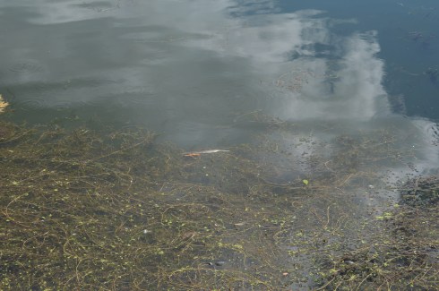
Birds aren’t the only inhabitants of the reservoir. Turtles and other aquatic animals occupy the reservior as well. It’s a little hard to see butt at the bottom of the second photo there is a huge turtle.
Since it was such a nice day outside, there were a variety of dogs at Chestnut Hill Reservation.
ViVi, a 4 year old Beagle and Cocker Spaniel mix, showed off her talents of doing a pirouette and playing patty cake to beg for treats.
This slideshow requires JavaScript.
This slideshow requires JavaScript.
Buster is a 9 year old English Lab and Retriever mix, or the best combination ever!
Bella is, appropriately enough, a 2 year old toy poodle. Doesn’t she look like a toy?
Luke, a 2 year old Lab, was a little shy but warmed up to the camera nicely.
Please check out my Facebook page to see other photos, videos and other content that is not included in my blog
and look for me on my Instagram page @new.england.nomad_
Location: 246 Dudley Road, Newton Centre, MA (there is also an entrance on Farina Rd)
Hours: open daily, dawn to dusk
Cost: Free
Parking: There is a designated parking area for about 6-8 cars. People park on the side of the entrance when the regular spots fill up (see below for photo of parking lot)
Park Size: 100 acres (conservation area is 32.2 acres)
Trail Difficulty: Easy
Highlights: Easy trails, sculptures displayed around the park (until Nov. 11th, 2016), wildlife, pretty trees and flowers
As if Kennard Park wasn’t pretty and interesting enough on its own, sculptures have invaded the park. The Kennard Park Sculpture Trail is a diverse display of art with social , personal and political messages. But, hurry if you want to view it. It is scheduled to be on display until November 11th of this year.
I want to give credit to 52 Sundays-Halpern Blog for posting a blog about this amazing exhibit. Stop by and check out halperns’ blog!
The sculpture trail includes sculptures from 15 different artists. There are sheets of paper hanging from the exhibits or near the exhibits which give information about the artist and some of his or her inspiration behind the sculptures or art. The sculptures may not seem to go in order numerically if you start the trail from the parking area because there are several sculptures and works of art on the front lawn. I am listing the sculptures and pieces of art in numerical order based on the map key which is available at the park. Free handouts for the trail are located on one of the tables at the entrance.
The first sculpture by Jean Blackburn is called Kennard Web. She states she is fascinated by the age of trees and their ability to adapt or effect their environments. She also states she would like to create a “weave of connections” through this art work. The work of art would make visible the singular configuration of the community of trees at this time and place.
The second set of sculptures, by Paul Walker, are called the Nattural Balance Benches and Bridge Bench. These tables and bench are a combination of rough and refined, accordiing to Walker’s write up. They are natural and hand made. They are comprised of black walnut is in Newport Bay and sediment stone with stainless steel posts.
Murray Dewart’s sculptures are the third work of art on the trail. His sculpture entitled, “Pavilion Of The Sun” is meant to convey something aspirational, both spiritual and monumental. The Sun Pavilion has the promise of something ceremonial and celestial, open to the sky.
The welded aluminum 15 foot gate is powder coated and installed in three sections. On the inner face of each column inside the pavilion is a mirrored surface of stainless steelthat reflects the sunlight with the faces and bodies of the visitors.
Dewart also has a bright red aluminum gate as part of his exhibit.
The Propeller Bench by Kit Clews is the fourth exhibit on the sculpture trail. The Bench Propeller is an ultralight cooling station. Kit imagined a tree branch with a gently spinning propeller in place of leaves which are create cooling breezes whilst they lounge together under the kinetic propeller tree. As the spinning wheel turns, visitors are free to visualize “whirled peace” and perhaps, someday, “the wheel thing.”
The fifth exhibit is a “Reflection on the Ornithology of Naturalist-Conservationist Frederick Kennard and Memorial to Extinct Species” by Charlet Davenport. As the name suggests, the exhibit honors Frederick Kennard’s interest in birds and to the extinct species of birds who used to roam these woods.
The exhibit includes eggs with names of extinct species on them (the very same eggs, except they are not real, that Kennard would collect) as well as porcelain forms in the shapes of Japanese lanterns which are meant to mimic the paper lanterns which were used as ornaments during the times of Frederick Kennard. A stoneware birdbath is located next to each tree.
Biomimicry Rain Harvester by Allison Newsome is the 6th exhibit on the trail. Her sculpture is made of steel, cast bronze rain chains, aluminized steel culvert and garden hose. It is a functional sculpture that harvests rain water. It holds up to 700 gallons of water and it has a hose attached that can be used for gardening and help in conserving the use fo town water by using the water it collects instead. Biomimetrics is the immation of nature to solve complex human problems. Biomimetrics is a combination of “bios” which is Greek for life and “mimesis” which means to imitate.
Marek Jacisin’s “Visual Playground” (the 7th exhibit) is meant to transform that part of the park into a visual playground. The sculpture recreates elements of a board game. The pieces of the exhibit are the player pieces of the game and the park is the board, according to Jacisin. Jacisin was aiming (no pun intended) to provide a stark contrast with the black and white spinning circles and the asymmetrical shapes. Jacisin goes on to explain that “nothing is ever as it seems.”
Once your eyes refocus, you can make your way to the next exhibit (exhibit number 8). Zoe Friend’s exhibit may be hard to find if you don’t look hard enough. Somewhat off the main trail, past the parking area and closer to the office, Zoe Friend’s exhibit “Bromeliads” is a tribute to her mother. While researching charm bracelets, Zoe came across her mother’s old charm bracelet and she wanted to create something that would showcase some of the things her mother loved such as fuschia flowers. Specifically, Zoe remembered how the rain cascaded off the flowers and how they clung to the very ends of the stamens after a shower, cementing them as the perfect crux between the rain chain and the her mother’s charm bracelet.
The ninth exhibit by Caroline Bagenal is called “Strata.” If, like me, you begin the trail at the area closest to the parking area, this may be the first sculpture you see. The elements of the Strata sculpture were inspired by the park itself. Bagenal states she was first attracted to the land of the park and the apple trees in front of the house as she first came into the park. She was also attracted by an old well on the corner of the property and the old stone walls she passed by while walking through the park. She also learned part of the park used to be used as a landfill which lead her to the idea of making an exhibit with levels of both “man-made” and “natural” levels. As you can tell the sculpture includes natural things as well as man made materials. Layers of thought, time and place are included in her sculpture. She specifically chose the perennial garden to display her art because it suggests a clearing but with encroaching woods. Even the books she chose to include in the sculpture such as a book by Robert Frost and a building construction book seem to add meaning to the exhibit.
“Color Notes” by Anne Spalter is the tenth sculpture on the trail. Spalter’s exhibit includes three pieces; digital wallpaper, video work and exterior sculpture.
Digital Wallpaper is meant to be a main conference room with a large-scale kaleidoscope composition that integrates images of the wooded area during winter. The video work is a “color piano” video that uses color notes from winter and fall creating an abstract piece that calls attention to the changing seasons. The exterior sculpture aspect of the sculpture are meant to highlight the transparency of the “keys” with the colors of nature showing through.
Peter Diepenbrock’s sculptures are the eleventh part of the trail. Peter’s art consists of four pieces. His collection, called “Buddhati’s Dream: The Transference”, includes
“The Lost Boy”
“Spirit Ship”
Spectral Shift II
and “Pegasus”
Peter’s intent was to create a strange otherwordly environment of alien-esque artifacts with fragments of alien intelligence or presence set in an otherwise perfectly quiet, natural environment.
To my surprise and delight, Peter was there to discuss his art and some of the details about his sculptures. In fact, the artists may be appearing from time to time at the park to meet people and discuss their works.
The twelfth exhibit is “Totems” by Deborah Putnoi. “Totems” is in part an interactive exhibit. Rocks and signs with words and phrases of good advice such as “breathe”, “imagine and “be open” are strewn throughout the trail and on trees. People are encouraged to draw their own art based on the nature they see on the totems and on paper which provided.
Putnoi, who grew up in Newton and presently lives there, wanted to make a piece that is subtle and doesn’t detract from the nature. The stones are meant to reflect aspects of the layered and embedded history in the toen as well as the history of the trail and space.
The next exhibit (number thirteen on the sculpture tain) is by Marco Vargas. Marco’s sculpture was inspired by Ehecatl; the Aztec god of wind whose breath gave movement to the sun and gives life to the lifeless. His love is symbolized by a tree that grows in the place where Ehecatl arrived to Earth. Since Kennard Park is a natural zsetting, Vargas wanted to use natural materials to his sculpture. He used red mud where graffiti hexagons draw the god of wind. He also used branches and logs.
The fourteenth exhibit on the trail is “Sacred Space” by Carolyn Kraft. Carolyn’s work of art is a reflection the beauty of nature and how we can appreciate it in our life. She loves to make dwellings of nature from nature. Carolyn thinks we can find contentment and be more connected to earth through her art. Inside the hut are chairs made of stone with moss on them. The beads which hang in the area change color based on the direction of the sun.
The fifteenth and final work of art is “Silent Spring” by Mary Dondero. As the title would suggest, Mary’s art is based largely on Rachel Carson’s ground breaking book, “Silent Spring” which revealed the indiscrimate use of pesticides and how it affected our environment, particularly birds. Mary’s exhibit includes 200 shimmering white objects at the base of the tree, all silent. Most of the bird objects are clustered near an almost dry brook or stream. She included ceramic hands in the stream-bed. The hands may appear to be ripples of water when the water returns to the area. Her goal was to imply that it is by our own hands that these songbirds have diminished in population. Although it is explicitly explained in the paper explaining the art hanging near the exhibit, I interpreted the cloths on the rocks on the ground to be dead birds, perhaps due to the use of pesticides and other detrimental human made causes.
Besides, the works of art, there were many other pretty and interesting things at the park.
And, of course, there were dogs at Kennard Park. With its easy trails and spacious areas to roam, Kennard is an ideal place to take your dog for a quick walk.
Frederick, a 4 year old Chihuahua rescue, had to take a big stretch before he began his walk..
Sally, a 3 year old Golden retriever, walks the trail almost everyday. She was more interested in playing with her stick than looking at the art.
Truffles, a 6 year old Italian Waterdog, lied down and took in the art at the park.
Pika is a 12 year old Border Collie. The name Pika is derived from the name of the pica font style.
Below is a video of Peter Diepenbrock’s Spectral Shift sculpture. In the background, you can hear him discussing his art.
Standing at 3,165 feet, Mount Monadnock is considered one of New Hampshire’s “easier” climbs (according to alltrails.com). But, before you lace up your hiking boots and pack up your car for the scenic drive to the majestic mountain in Jaffrey, New Hampshire, you may want to get a second opinion.
While it isn’t the hardest climb you will make, it also isn’t an easy climb, particularly for beginner climbers. I saw more than a few climbers taking breaks on the side of the trail to the top. But, it is worth all the hard work and time to get to the top when you see the views.
At the beginning of the trail, there is a reminder to not make or knock down the cairns on the trail.
The dirt trail at Monadnock starts off easy enough as a straight trail with a slight incline. From there, the trail gets tougher. The inclines become more drastic and the terrain turn rocky.
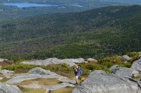
There are some pretty views on the way to the top. About three quarters of the way to the top of Mount Monadnock, there is an area to sit or stand and take in the views of the surrounding area. On a clear day, you can see the Boston skyline. You may be able to see it in some of these photos.
The trail gets slighly easier after the first 3/4 of the trail. But only slightly. Keep in mind this was my first hike up any mountain. So, it may be much easier for an experienced climber. In any case, there are several areas to take photos as you inch closer to the top.
Finally, I made it to the top. It took me about 2 to 2.5 hours to get to the top. Bear in mind I had a camera with me that I had to make sure I didn’t hit against a rock (I always keep the camera by my side and not in my backpack or carrying case because you never know when you might need to take a photo at a moments notice) and again it was my first time hiking anything this size. So, an experienced hiker without a camera would probably be able to complete the ascent in about an hour.
The views from the top are breath taking. Be sure to take a sweater with you, even if it is a warm day when you go, because the winds at the top of the mountain are very strong.
I had enough trouble hiking up to the top by myself, never mind doing it with someone strapped to my back like this guy!
Due to the geoloical makeup of Mount Monadnock, there are some little ponds of water and colorful grass at the top.
Keep in mind, Monadnock is a very popular attraction and the trail does get busy quickly, especially during ideal hiking days.
If you’re lucky, you may run into Larry Davis. Larry has been hiking Monadnock virtually everyday (rain, snow or shine). he has easily logged in thousands, probably tens of thousands, of hikes up and down Mount Monadnock. He also takes some beautiful photos from Monadnock on a camera with film. He was nice enough to pose for a few photos for me.
I found some other cool things on the trail. There is a flying insect of some kind that makes a clicking sound while it flies, signs of fall and some interesting rocks with names etched into them. The names etched into the rocks are the names of the families that lived at the bottom of the mountain or the surrounding areas and some are said to still live there today.
Mount Monadnock also has comfort stations and a general store at the base of the hill so you can refill the calories you will surely burn hiking.
In short, Mount Monadnock is the perfect hike for beginners and experienced hikers. Hopefully, I’ll see you up there soon!
Below are some videos from my hike at Mount Monadnock. You can hear the wind blowing in some of the videos.
Location: 145 Lang Rd, Windsor, CT (15 mins north of Hartford, CT and half an hour south of Springfield, MA)
Hours: Open everyday, sunrise to sunset
Parking: There is ample parking(about 100 parking spots) in the main parking area as you enter by the soccer and baseball fields. There is also a smaller parking area by the dog park on your right as you enter the park that can accommodate about a dozen cars.
Cost: Free
Size: 473 acres, 12 miles of trails
Trail Difficulty: Easy to somewhat moderate in some areas
Time To Allot For Visit: 2 to 3 hours
Dog Friendly: Yes
Highlights: dog park, ponds, trails, flowers, reservoir, ball fields, wildlife, animals, tobacco museum, venue for events during the spring and summer
Since summer is winding down, I decided to take in one last trip to one of New England’s more popular parks while the weather was still warm.
With over 12 miles of trails, a reservoir and miles of trails, Northwest Park is a scenic, family friendly park that is a great place to take your dog.
At the entrance of the park, there is a small, penned in dog park called the Windsor Dog Park.
In a way, it is odd to have a dog park in a park that is essentially a dog park. I do suppose the penned in dog park would be good for dogs that may be too aggressive to be around other dogs or might be too shy or not yet socialized.
Along the trail past the main entrance, there is a pond with an overlook. The pond is full of turtles, frogs and even Koi fish. One of the visitors at the park threw some bread into the pond. Who knew turtles liked to eat bread!
There is also an organic and community garden at the park.
There is also a barn with farm animals and other animals at the park.
One of the special parts of the park is the art scattered around the park.
The trails at the park are pretty much flat and easy to negotiate with some slight inclines.
There are several trails at Northwest Park. We took the Brookside and Rainbow Reservoir trails. The Brookside trail is heavily wooded without much to see except a few chipmunks. The name Brookside seemed a bit misleading as there really wasn’t a brook to be found from the trail.
Eventually, we found ourselves by the Rainbow Reservoir. The surface of the water was a strange shade of lime green.
There were some boats in the water and even a water skier.
The trails are full of pretty trees, colorful flowers and a few abandoned barns.
You ever notice what the inside of an abandoned barn looks like? Then, wonder no longer. It’s actually pretty boring. The video below gives a better look inside.
There were also a lot of critters to see along the trails. This chipmunk thought she could hide from me.
This squirrel wasn’t any better at hiding.
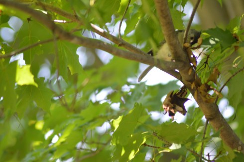
This bird was a bit better at hiding.
Finally, on our way out of the park, we decided to check out the tobacco museum. The museum shows the history of the tobacco crop industry and the tools and machines they used.
Northwest Park is a great place to take your dog. The trails are not very hard to walk and there are lots of open spaces for your dog to roam. I found two very friendly dogs to photograph during my visit.
Tally is an 11 year old Shephherd mix.
Lada is a 1 year and 7 month old German Shepherd.
Below is a video of the water skier I saw at Rainbow Reservoir and a video of the inside of the abandoned barn I saw along the trails.
Please check out my Facebook Page and like it to see videos, photos and other content not included in this blog:
Parking: There are about 50 parking spots in the main lot and several additional parking areas farther down the road in the park.
Cost: $5 MA Vehicle, $6 non-MA Vehicle
Time To Allot For Visit: 1 hour to 3 hours
Trail Difficulty: Ranges from Difficult (The Chasm) to easy (The Charley Loop)
Highlights: interesting rock structures, jagged, rocky trails and wildlife
Lowlights: some of the trails can be dangerous, especially if there has been rain or snow in the area or if you do not wear proper footwear (hiking shoes are recommended)
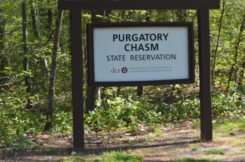
Purgatory Chasm might evoke images of the afterlife or the apocalypse. But, no, it’s actually in Sutton, MA.
The trail of jagged stones is only .25 miles but they are difficult to cross in some parts and particularly dangerous when you’re carrying a camera.
The Chasm is believed to have originated because of the sudden release of dammed-up glacial meltwater near the end of the last Ice Age, approximately 14,000 years ago.
Almost as difficult is the incline next to the Chasm with such areas as as The Corn Crib, The Coffin, The Pulpit, Lovers’ Leap and Fat Man’s Misery. The inclines are very steep in some areas on this route. There are areas that have a smoother, less sharp incline (look for the rocks on the right side of the incline for these smoother declines). I had to take the more steeper inclines and declines, of course. Some of the views from the ledges are a little scary if you don’t like heights. Some of the heights are as high as 70 feet in some areas and the rocky terrain below would not make for a very safe landing.
There are several trails you can take after tackling the Chasm. We took the Charley Loop – an easy, mostly smooth trail with pretty flowers and rocky structures that is just over a mile long.
While walking along the Charley Loop, we found a rock with a strange crystal-like powder on it.
These crystals are Granite Pegmatite which is made up of clusters or clumps of minerals. They generally contain mica, feldspar, beryl and quartz.
Beyond the chasm there is a pond with frogs, birds, possibly some turtles, flowers, and, of course, rocks.
There is also a large rock with a steep decline that has a slippery surface. We found some children (and a few adults) sliding down it.
Purgatory Chasm is a great place to bring dogs for a walk (I would avoid taking them on the Chasm trail). We saw a few dogs during our visit.
Gisele (not Tom’s Gisele, at least I don’t think so) is a 8 year old Yorkie.
Sawyer is a friendly 3 and a half year old Golden Retriever.
Charlie is a rescue dog who was being fostered. Since he was a rescue, his foster family didn’t know his exact breed or his age. He was taken in from the Lighthouse Animal Shelter in New Bedford, MA. Hopefully, he has a happy new permanent home now.
Below is a video looking over one of the many edges of the rocky incline next to the Chasm.
Please check out my facebook page and like it to see videos, photos and other content not posted on my blog. Thank you!
Parking: There is free unmetered off street parking available but only a dozen or so cars can fit on the side street. You may be able to park somewhere else nearby and walk to the dam.
Highlights: pretty waterfall, birds, pretty architecture, family friendly
Established in 1933 on the site of a former grist mill, the South Natick Dam Park attracts people far and wide for its pretty waterfall and scenic views. Construction of the South Natick Dam was completed on September 2, 1933. It replaced a timber dam that had been built at the site since 1760 by Matthew Hastings.
Millstones from the grist mill, which had served the area since colonial times, are embedded in the paved area of the area surrounding the dam.
There is also an island in the middle of the river, that you can see in some of the photos, which is named for Horace Holyoke, one of the characters from Harriet Beecher Stowe’s “Old Town Folks.” This character is based on her husband Calvin Stowe who was a South Natick native.
Since the water was at such a low level, I was able to walk down to the base of the dam and take some photos from where the water would normally be.
The South Natick Dam Park is adjacent to the Charles River’s dam, and is a popular spot for visitors, both human and animal.
A fun and unexpected stop on my way home from Broadmoor Wildlife Sanctuary, the South Natick Dam is a great place to take your dog for a walk, photograph or just sit at one of the benches and take in the beauty of the area.
(hours may vary depending on the time of the year)
Parking: There is unmetered off street parking available (2 hour limit) and a free parking area off Baker Ave with about 30 -40 free spots (take care not to park in the spots reserved for businesses and other tenants in the area) and additional off street parking. Parking is difficult during peak times
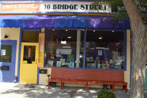
Few things go better than cats and books. And Boswell’s Books is proof of this.
Formerly named the Bridge Street Bookshop until 1991, Boswell’s Books was originally named after one of the previous owners’ cats, Boswell. Since then, the book store has gone through some changes, including changes in location and changes in ownership. But, the one mainstay has been Boswell.
The current feline resident of the bookstore, a 7 year old female tuxedo cat, is the fifth Boswell.
We found her resting in the front window taking a much deserved cat nap.
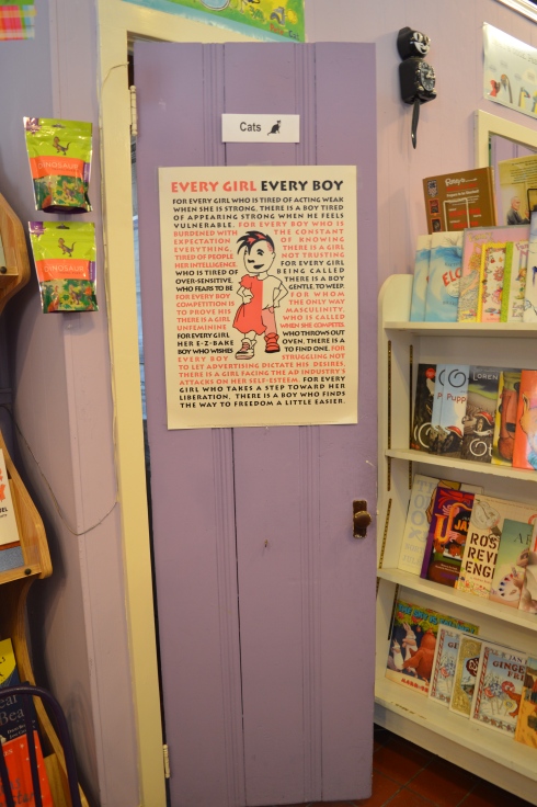
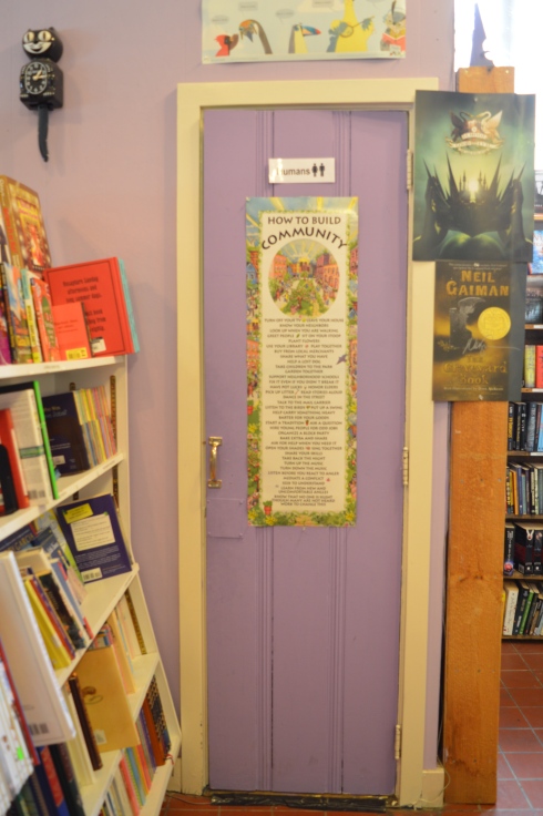
Boswell’s books has cute decor and, even though they may not be as big as some of the other bookstores, they make good use of the space they do have.
They even have acommodations for everyone, people and felines.
Boswell’s also holds special events such as book signings and book readings. It’s a must-see if you’re in the Shelburne Falls area!
There are so many fun places to visit in Shelburne Falls. In fact, one need only to walk along Bridge Street to find some wonderful places to shop. I have always found these smaller, independtly owned businesses to have such friendly and great service. Plus, it’s always good to support locally owned businesses.
Mocha Maya’s Coffee House (47 Bridge St) is a cozy little coffee shop where you can bring your recently purchased book to read and have a coffee, sandwich or blended drink. They also host musical events.
Unfortunately, the Trolley Stop Antiques and Collectibles shop was not open during our visit. As you can see, the shop has some very unusual products.
Even if you don’t want to stop in at any of the shops or diners, Shelburne Falls is a great place to walk around and appreciate the views and the atmosphere.
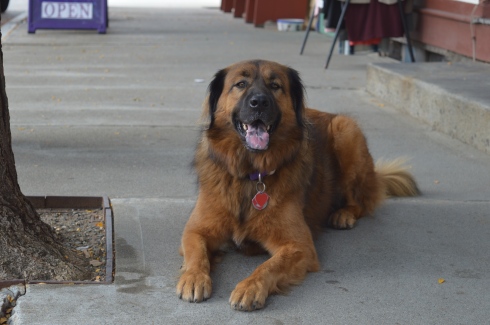
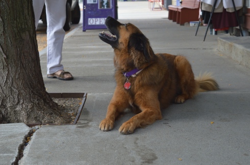
Boswell wasn’t the only pet I saw at Shelburne Falls. Catfish (named after legendary New York Yankee pitcher Catfish Hunter) is a 4 year old (he will be turning 5 in November) Leonberger. Leonberger’s are a large breed dog that were popular in Germany. They were originally bred to be a symbolic dog that would mimic the lion in the town crest of Leonberg in Baden-Wurttemberg in Germany. He’s truly a gentle giant.
Location: 22 Water St, Shelburne Falls, MA (1 hour west of Springfield, MA, 1.5 hours east of Hartford, CT and about 2 hours west of Boston)
Hours: Open April 1 – October 30, 24 hours a day
Cost: Free
Parking: There is available off street parking (the 2 hour unmetered parking limit on Bridge St is strictly enforced) and a free parking area off Baker Ave with about 30 -40 free spots (take care not to park in the spots reserved for businesses and other tenants in the area) and additional off street parking. Parking is difficult during peak times.
Size: 400 feet long, 18 feet wide
Time To Allot For Visit: 30 minutes an hour.
Dog Friendly: No
Highlights: pretty flowers, scenic views, memorials, works of art, a master gardener is available on the bridge during peak weekends to ask questions about your own plants and gardens
Lowlights: bridge can get congested since it is narrow
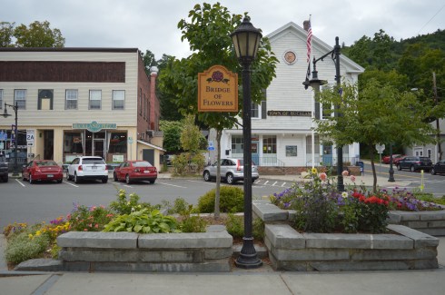
Built in 1908 for a measley $20,000 (roughly $500,000 in current day’s money) by the Shelburne Falls and Colrain Street Railway, the Bridge of Flowers is now home to a wide variety of flowers, trees and even some works of art.
Originally, the bridge was used as the main mode of transportation for the community. However, once cars became more popular, the train was used less and the company went out of business. Since the bridge could not be destroyed because it carried a water main between the towns of Colrain and Shelburne Falls, it was decided to do something with the bridge. Then, in 1929, the Shelburne Women’s Club sponsored Antoinette Burnham’s idea to transform the bridge into a garden.
More than 35,000 people visit the bridge ever year. Yet, it is still something of an unknown attraction, even in New England.
Much to the consternation of my company, I can be very particular about my photos (although my guest on this day didn’t complain). I tried my best to take photographs of the bridge without any visitors on the bridge or with as few people as possible on it and wow did it take a while to get those shots which just goes to show how much foot traffic it can get. But, I did eventually get my shots of an empty or close to empty bridge.
This post is photo-heavy. As much as I tried, it was very hard to choose flowers to include and which ones to not include.
The hardest part of this photo shoot was selecting the best photos to post. The flowers are so pretty and the view nothing short of jaw dropping. The flowers are also beautifully arranged. I especially liked how the flowers complimented the landscape.
Birds and bees like the flowers, too.
Flowers and trees aren’t the only attractions at the Bridge Of Flowers. Memorials and art are scattered throughout the bridge.
One of the works of art at the Bridge of Flowers is a stained glass window designed by Nancy Katz and created by Mark Liebowitz at the Garden House. It is illuminated during the evening.
This water fountain is also at the area past the bridge.
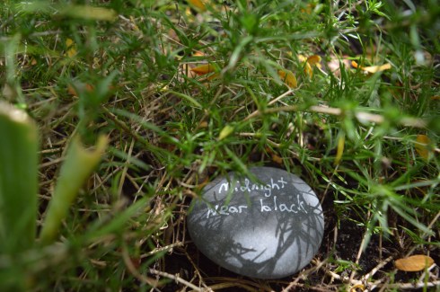
I noticed this in one of the flower beds. What is it? A coded message? A plan for a secret rendezvous?
Also, and not least, there are war memorials on the bridge. This memorial honors the veterans of World War I and World War II of the Buckland and Shelburne areas. While it honors all of the veterans of these wars, the names of those made the supreme sacrifice from these areas are engraved on the plaque on the stone.
This memorial honors the veterans of Korean and Vietnam wars. The names of the peolpe from the community who lost their lives in these wars are engraved on the plaque on the stone.
Another great thing about the bridge is they plant flowers each month and it is “peak season” for different flowers at different times (their planting schedule is on their web site). So you’re sure to see something new and pretty any time you go. However, I would suggest going during the summer or, preferably, the fall.
The Salmon Falls and Glacial Potholes attraction in Shelburne Falls, MA, is a beautiful “two-fer.” “Three-fer” if we include the bowling alley adjacent to the Salmon Falls and Glacial Potholes attractions. IN fact, it is more accurately described as a “many-fer”s there are many attractions and beautiful attractions to the Salmon Falls area.
Although it may be best known for The Bridge Of Flowers (post to come shortly), beauty and grandeur abound Salmon Falls/Glacial Potholes area on Deerfield Ave.
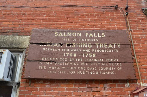
The glacial potholes were ground out of granite during the high water of the Glacial Age. The whirlpool action of the waves and the gyrating stones created the prominent holes in the stones. It is said some of the grinding mills can still be seen in the smaller potholes. Over 50 potholes exist in the confined area known as “Salmon Falls” when the the Native Americans resided here. The potholes vary in size from 6 inches to 39 feet in diameter. The 39 inch diameter pothole is considered the largest pothole on record. And you thought the potholes on our roads were bad.
Salmon Falls, as it was dubbed by the Native Americans, was a common area for hunting and fishing. The waterfall still gives some pretty views against a once industrialized scenery as the backdrop.
What makes the Salmon Falls and Glacial Potholes area are the small shops and antiquated buildings that give the area a very old fashioned small town feel. This is true for pretty much the entire community of Shelburne Falls.
There is a bench for sitting, feeding the birds and just taking in the beauty around you.
Almost as a prelude to the much heralded Bridge of Flowers (which is located only a short walk or drive from the Salmon Falls and Glacial Potholes area), flowers and trees bound the Salmon Falls area.
If you’re lucky you might even find a feathered friend to photograph.
Deerfield Ave, the road that leads to Salmon Falls and the Glacial Potholes, still has the old town feel that adds tot he charm of the area. In fact, the entire Shelburne Falls area still has many “mom and pop” shops and independent businesses rather than chain stores. It was nice walking around without being bombarded by convenience stores and restaurant chains that seem to scar so many other towns.
The Shelburne Bowling Alley is one of the oldest bowling alleys in the country. In operation since 1906 (and yes it is still open for business currently), the Shelburne Bowling Alley could easily be mistaken for a barn or some other structure from a different time.
There is also a variety of art throughout the area. Some of the art I noticed looked different from the art I have seen in previous visits. So it appears they do change it up every so often. The art honors the history of the area and gives information about the area.
Below is a video of the falls at Salmon Falls. It was an overcast and somewhat windy day when we first arrived at the Falls so you may hear the wind in the video. But, most of the sound is from the rushing waters of the Falls.