Category Archives: birds

Oak Knoll Wildlife Sanctuary (Attleboro, MA)

Dates Of Visits: May 20 & June 19, 2017

Location: 1417 Park Street, Attleboro, MA

Hours: Trails are open daily dawn to dusk.  Office hours are:

Summer:
Mon-Fri, 9:30 am-4:30 pm
Closed Sat & Sun

Spring, Fall, Winter:
Tues-Sat, 9:30 am-4:30 pm
Sun, 10 am-4 pm
Closed Mon

Cost: Free but a $2 donation is suggested for visitors who aren’t members of the Mass. Audubon Society

Parking: There is ample parking inthe main parking lot for about 40 to 50 vehicles.

Trail Size/Difficulty: 1.5 miles, easy

Handicapped Accessible: The nature center and rest rooms are handicapped accessible.  The trails at Oak Knoll are not.

Dog friendly: No, most Audubon trails are not pet friendly

Highlights: wildlife, pond, easy trails, geo-caching, summer camp for children, nature center

Website: Oak Knoll Wildlife Sanctuary

Trail Map: Oak Knoll Wildlife Sanctuary Trail Map

Located about a mile and  a half from Attleboro Springs Wildlife Sanctuary, Oak Knoll is a fun trail with with scenic views, abundant wildlife and a few other surprises along he way.

Spring was in the air and a rebirth of sorts was happening on the trails.  During my first visit, I found these two Northern Water Snakes getting friendly.  To be honest, I wasn’t really sure what I was looking at.  But, I did think at the time I did hear the faint sounds of Al Green in the air.  The naturalist at the nature center told me you could tell they were mating by their interlocked tails.

The Northern Water Snake can be dangerous.  Although they usually tend to avoid confrontations, if they feel threatened the snake can bite their predator or perceived predator and their bites can require medical attention.  This is why I always tend to keep my distance (these photos were taken with my telephoto lens) and from behind in most of the shots I took except for the one front facing photo.

During my second visit in June, I noticed this turtle on the trail.  Since it is unusual for a turtle to be in the trail and its even more unusual for a turtle to not flee when they see a human (I could have pet the turtle I was so close although of course I never would at least not int he wild), I notified the naturalist since I thought maybe the turtle might be injured.  The naturalist told me the turtle was most likely laying her eggs as they often do this away away from the water and it was that time of the year when turtles will lay their eggs.

The naturalist also informed me that turtles also tend to lay their eggs on warm areas, such as the side of paved roads.  This is one of the reasons why turtles often get hit by cars on the side of the road.  So, be careful while your driving this time of the year!


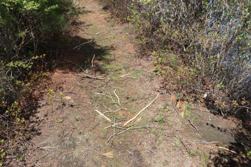
The trails at Oak Knoll are easy with some boardwalks that pass over red maple swamps and freshwater marshes.  There are a few very slight inclines.  But the trails are primarily very easy.

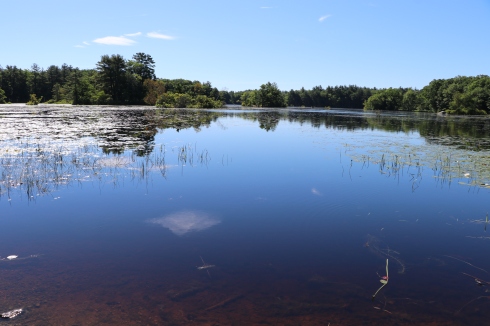
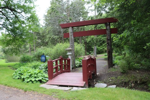
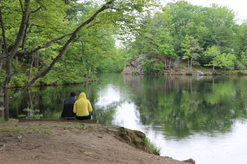
The main trail at Oak Knoll is a loop that leads to and circles around Lake Talaquega (say that 5 times fast).  There are some pretty views of the lake along the way.

I also spotted this geocache off the trail.  Apparently, a regular visitor at the sanctuary installs these geocaches from time to time.

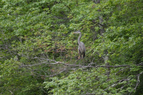
There are a wide variety of birds and other critters at the sanctuary.  This colorful insect is a six pointed tiger beetle.  I think they call him Ringo.

DSC_0780

There was also butterflies, garter snakes and a variety of birds.

The nature center at the entrance to the trails has amphibians in tanks that are being taken care of while they are rehabbed or are there for educational purposes, particularly for the children who are attending the summer camp they host.  They also have some pretty flowers and trees on their grounds.

Today’s Nomad link of the day is the North Attleboro Fish Hatchery by Trails And Walks In Rhode Island.  Trails And Walks offers informative and detailed summaries of different trails in and around the Rhode Island area.  I appreciate the short but sweet synopsis of each trail and the posts always include one pretty photograph of the area.  I may have also used the website to find some places to visit!


Attleboro Springs Wildlife Sanctuary (Attleboro, MA)

Dates Of Visits: May 20 & June 19, 2017

Location: Park St, Attleboro, MA (behind the La Salette Shrine at 947 Park St) (45 minutes southwest of Boston, MA, and 15 minutes northeast of Providence, RI)

Hours: Open daily sunrise to sunset

Cost: Free but donations are appreciated

Parking: There is room for about 10 cars in the lot next to the trail.  You may also be able to park at the Lasallette Shrine in front of the trail.

Trail Size/Difficulty: 3 miles total (.5 handicapped accessible), easy with a few gentle inclines

Handicapped Accessible: Yes, .5 miles of the trail are handicapped accessible with boardwalks, along the pond and vernal pool.  The rest of the trails are dirt, narrow and rocky and not handicapped accessible.

Dog Friendly: Dogs are not usually allowed on the Audubon trail but they are allowed in certain sections of the trail at Attleboro Springs (on the reflection trail I believe)

Website: Attleboro Springs

Trail Map: Attleboro Springs Trail Map

Highlights: wildlife, vernal pool,

Fitbit Stats: 2,712 steps, 242 calories, 1.19 miles

DSC_0076

Often overshadowed by the more well known cities and towns  south of Boston, Attleboro, MA, is one of the more underrated sections of Massachusetts.  It is also the site of two beautiful Audubon sanctuaries (Attleboro Springs and Oak Knoll) .  I decided to visit Attleboro Springs first.

Attleboro Springs is a little hard to find.  Basically, look for the La Salette Shrine on Park St.  The path to the trail is the very next turn after the shrine.

From the entrance to the park, one word comes to mind – charming.  A pavilion and map of the trail are located on the trail at the entrance.

The main trail at Attleboro Springs is the Reflection Trail.  The Reflection Trail encircles a pond.  A vernal pool with a vernal pool are also on the trail.  It is the easiest trail to take, although there are additional side trails.

Birds, frogs, tadpoles and other kinds of wildlife are abundant along the trail, particularly at the pond and vernal pool.

I love side trails and going off the beaten path.  So, of course I tried them.  There wasn’t much to see except a brook and a cool bridge on the side trail.

The Reflection Trail is very easy with few inclines or rocky terrain which makes it ideal for jogging on or taking walks on, particularly since it is a short trail (about 3/4 of a mile).

I know I write this often.  But, what the heck.  I could spend all day here.  The trails are easy.  The pond is a popular spot for birds and aquatic life (naturally).  And there are seats to watch all the life around you.  As an added bonus, it’s free to visit.  It’s usually the smaller, charming places that stick with me.  In fact, I liked it so much I visited it twice.

The Nomad’s link of the day is a blog post by WordPress blogger and fellow New Englander  Kristen.  Kristen’s blogs are peppered with book reviews, pretty photos and interesting observations.  Kristen posted about  place that is very close to this trail and is one of the more popular places in Attleboro,    La Salette is a popular place to visit year round.  But, it is especially busy during the winter each year when they host a holiday light display.  You can find Kristen’s wonderful blog post here.


Harold Parker State Forest (No. Andover, MA)


Date Of Visit: June 25, 2017

Location: 305 Middleton St., No. Andover, MA (about 30 minutes north of Boston and about 1 hour southeast of Concord, NH)

Cost: There are several parking stations to pay per the hour or you can park at the headquarters which is what I did.  There wasn’t a charge to park at the headquarters the day I visited.   The charge to park at Berry Pond is $5 for MA vehicles; $6 for non-MA vehicles

Hours: trails are open sunrise to sunset.  Berry Pond Beach is open 10am-6pm from June 25- Sept 5.

Parking: There are several parking lots throughout the automated pay stations.

Trail Size/Difficulty: 35 miles of logging roads and trails/easy with some challenging inclines

Handicapped Accessible: Yes, the main paves trail is and Berry Pond has several handicapped parking spaces right near the beach.

Dog Friendly: Yes

Highlights: wildlife, beach, lakes, extensive trail system, campground area, rock climbing

Website: Harold Parker State Forest

Trail Map: Harold Parker State Forest Trail Map

IMG_6181

One of the more vast state forests I have visited to date, Harold Parker State Forest boasts over 35 miles of trails and roads, a beach (Berry Pond), several ponds and lakes and a variety of wildlife.  I spent over 6 hours there and, while I did cover a lot of ground, there was surely some a lot I didn’t see.  Tip of the day: if you do go, bring a trail map!

The trails at Harold Parker are generally easy with some moderate inclines.  Due to the various streams and wetlands, there are also several boardwalk trails.


Harold Parker is a popular spot for cyclists.  According to the New England Mountain Bike Association (NEMBA) the single track riding rates at Harold Parker State Forest are: 30% easy, 30% moderate, and 40% difficult with some rocky sections.

It is a little difficult finding the exact entrance to Harold Parker (I found 3 different addresses but I included the address of the headquarters at the top of this post).  It’s not a bad thing, though, because you can park in any of the various parking areas.  Just to make  sure to pay at the pay station when you do park.  You can also drive to each different parking area as the main road is paved and fairly wide enough for traffic, cyclists and hikers to share the road.

I began my day at Stearns Pond, one of the many ponds in the area.  Fishing is allowed and I met a friendly fisherman who goes there regularly to cast his lines.  They also allow non-motorized boating in the ponds.  There is an annual fishing festival held in September at the state forest.


Stearns Pond is only one of the many ponds, rivers and streams at Harold Parker State Forest.  In fact, it’s hard to keep track of which pond or river you are at, even with the aid of a map.  But, there were some amazing views from the various bodies of water.


Unexpectedly, I came across this huge rock.  I bet there’s a good story about this rock.  I couldn’t find anything about in my research, though.  It’s one big rock, though!  Right!?


One of the highlights of Harold Parker is Berry Pond which is essentially a beach area and playground for children and families.  It was a perfect beach day and the beach was packed.  But, with photographic trickery I was able to photograph the beach without showing the sun bathers and swimmers.  After all, not everyone wants to be seen in their Speedo.


Walking along the SKUG Reservation Trail, I came across the site of an old quarry and soapstone mill, the Jenkins Mill.  There’s not much now to indicate it was once a quarry.  If not for the marking on the map and a few rocks dispersed around the area, I would not have known it was once there.  It’s kind of a shame that something that meant so much to so many people and was once such an important part of the area is now little more than a blip on the screen.


There are lots of birds, chipmunks, frogs and other critters visible along the trail and in the water at Harold Parker.


Harold Parker State Forest is a dog friendly park.  However, I didn’t see as many dogs as I thought I would.   I did manage to see these three cuties, though!

Suzie is a 7 month old English Setter.  She is hearing impaired.  So, she can hear some sounds.  Her dad uses signals to help him communicate with her.


Bella (or “Bell”) is a 9 year old Beagle and Lab mix.


Herbie is a 1 year old Pit mix.


Below is a video of one of the brooks that runs through Harold Parker State Forest.  Enjoy!

Please connect with me on Facebook to see more New England related content!


Senator Joseph Finnegan Park (Dorchester, MA)

Date Of Visit: June 17, 2017

Location: corner of Taylor St. and Water St., Neponset area of Dorchester, Boston, MA

Hours: Open sunrise to sunset

Cost: Free

Parking: Parking is available by the main entrances on Water or Taylor St.  You can also park at Pope John Paul II Park on Hallet St or Gallivan Blvd as the trails for each park are connected

Park size/trail difficulty: 15 acres/easy

Handicapped Accessible: Yes

Dog Friendly: Yes

Highlights: scenic views, cycling/walking paths, wildlife

Website: Finnegan Park

IMG_4626

Bigger isn’t necessarily better.

Part of the Neponset River Greenway, at a scant 15 acres Finnegan Park is one of the smaller yet more charming parks to open in the Boston area.

Dedicated in May of this year, Finnegan Park is a small yet popular destination for anyone looking to get away from the hustle and bustle of the city it borders.

Some of the park’s more appealing features are the scenic views and birds that inhabit the area, if you find that sort of things appealing that is.  In the background you can see some of the residential buildings in the lovely Quincy, Massachusetts neighborhood. Egrets and Canadian geese are common visitors at the park.

There are also blocks of what looks like granite with words like “Charity” as well as the history of the area and descriptions of the wildlife in the area engraved on them.

One of the really cool things about the park is the train that passes by.  The very same train I take to work.

Named after former state senator and representative Joseph Finnegan who worked hard to revitalize the area, Finnegan Park is a great place to ride your bike, play hopscotch or take your dog for a walk.


Gladys had a fun time walking along the trails at Finnegan Park.

Finnegan Park is only one segment of the Neponset River Greenway.  In a future post I will be showing off another beautiful part of this project.


Stodder’s Neck (Hingham, MA)

Date Of Visit: June 15, 2017

Location: 467 Lincoln St, Hingham, MA (30 minutes southeast of Boston)

Cost: Free

Parking: There is ample parking for about 50 cars

Trail Size/Difficulty: .7 mile loop, easy trails with some gentle inclines and some side trails.

Handicapped Accessible: Yes

Dog Friendly: Yes

Highlights: wide trails, picnic tables, water fountains for Fido, harbor views, wildlife, well maintained trails and grass for dogs to play

Website: Stodder’s Neck

Trail Map: Stodder’s Neck Trail Map

IMG_2870

Once the site of a gravel pit, Stodder’s Neck is now one of the most popular dog parks in the South Shore (south of Boston).  In fact, as the photo below shows, the park was designed as a dog park, although humans can also use it for birding, observing other dogs or just taking a leisurely walk.

The park has a water fountain with a spigot at dog’s level.

IMG_2818

There is also a board for people to hang lost dog tags (on hooks at the side of the board) and photos of dogs (many of whom have passed on) who enjoy the park as well as other notes of importance.

Even the entrance to the park has been designed to help prevent dogs from running ahead into the parking lot by having a narrow entrance.  I believe you may also open the gate at a different point if you need more room to enter or exit.

IMG_3276

The dirt trails at Stodder’s Neck have benches and picnic tables dotted along the way for you to sit and give your dog a chance to rest.

The views along the trail are impressive.

But, the best part of the trails has to be the Weymouth Back River that forms the peninsula the park sits on.

And dogs seem to like the river as well.

There are also a variety of birds and other animals at Stodder’s Neck.  Egrets also nest there during the spring and summer.  I came across this Egret hunting.

I guess I got too close and scared him or her.

And what would a dog park be without, you guessed it, dogs!?

Moose is a 5 year old Lab.

Harley, 7 years old, is part German Shepherd, Great Pyrenees,  Malinois.

Kylie is a 5 year old poogle

Mindy is a 4.5 year old rescue.

Mya is a 4 and a half year old Shepherd and Lab mix.

Macy is a one and a half year old pitbull and boxer mix.

Yuki is an 8 month old American Eskimo.  Yuki, for those of you not in the know, means “snow” in Japanese.

Tank is a one and a half year old Field Springer.

Please connect with me on Facebook!


Wickham Park (Manchester, CT)

Date Of Visit: May 30, 2017

Location: 1814 Tolland St, Manchester, CT

The address on the website is for the back entrance which is locked   Do not enter this address into your GPS.  The best way to go is to follow the instructions on their website or try using the address listed above.  I had to pull into a Dunkin’ Donuts to get directions.

There is also limited free parking on a side street (Vernon Rd)

Cost: $5 per car

Hours: open daily, sunrise to sunset

Park Size/Trail Difficulty: 250 acres/easy trails with some gentle inclines

Handicapped Accessible: Yes.

Dog Friendly: Yes

Highlights: scenic views, ponds, wetlands, wildlife, art, well maintained grounds, disc-golf field, bird sanctuary, nature center, gardens, flowers,hiking trails, picnic areas, ample parking

Website: Wickham Park

Map of Wickham Park: Map Of Wickham Park

IMG_8017

Wickham Park has a little a bit of everything for everyone.  There are gardens, wetlands and hiking trails for the nature lover.  There is a nature center and bird sanctuary for animal lovers to learn more about the inhabitants of the grounds.  There is also a play area for children and a beautiful scenic outlook for people to sit and enjoys beautiful views of the Hartford area.  There’s even tennis courts, pavilions and a disc golf field.  It is also one of the most beautiful parks I have visited (I know – I say that about all of the parks I visit).

If you have limited time or you don’t want to walk around too much, I would suggest going to Lot B first.  But, you can drive from lot to lot so tall of the areas of he park are very accessible.

Lot B is across from the Japanese themed Lotus Gardens, Irish Garden and other natural beauties.

There are also pretty structures and statues along the paths.

Knot Garden has a maze (it’s not as easy as it looks), statues and beautiful flowers.

There is a wide variety of birds, mammals and other animals at Wickham Park.

I caught this bird taking a dust bath.

These frogs were busy.  So I left them to their privacy, as much as there is at a park.

DSC_0417

There is also a bird sanctuary at Wickham.  All of the birds at the sanctuary were either injured or unable to survive in the wild on their own.  And, it looks like more are on their way.

Not all of the animals at the sanctuary were birds.  This sneaky fella found a way to score some choice feed.

DSC_0501

There is also a fun and educational nature next to a playground.  The animals are the nature center were much easier to photograph.

Wickham Park also offers stunning views of the Hartford and surrounding area.

There is also a disc golf field and easy to moderate hiking trails.

Wickham is worth the visit just for the art and architecture and nature alone.  The trails and gardens are just an added bonus.

Dogs are allowed at Wickham Park.  I was able to click a few photos of Holly as she hunted for a rabbit.

The only bad thing about my trip to Wickham Park was getting there.  The website has the address listed as 1329 Middle Turnpike West, Manchester, CT.  This is the back entrance and there was a gate preventing entry this way.  The main entrance is actually on Tolland St.

If you do use the address on their website (1329 Middle Turnpike West, Manchester, CT), to get to Wickham, drive west onto Burnside Ave and take a right onto Long Hill Drive (at a set of lights after about a mile (a Dunkin’ Donuts and strip mall will be on your left).  Then, take the next right onto Tolland St. or Tolland Turnpike.  The main entrance to Tolland Park will be on the right after about a mile.

Please connect with me on Facebook to see more fun stuff that I do not include on my blog!


Puffer’s Pond/Factory Hollow Pond (Amherst, MA)

Dates Of Visits: May 24 & 29, 2017

Location: Mill St, Amherst, MA (about half an hour north of Springfield, MA and an hour and a half southwest of Boston, MA)

Hours: Open daily, sunrise to sunset

Cost: Free

Parking: There is a designated parking area for handicapped accessible vehicles.  All other vehicles should park on the side of the road on the right hand side of the road.  There is room for a dozen or more cars to park on this road.

Handicapped Accessible: Yes.  There is a paved path and designated parking for handicapped accessible vehicles.

Dog Friendly: No.  But, dogs are allowed on the Robert Frost trail that circles the pond.

Highlights: wildlife, fishing,trails,pond

Website: Puffer’s Pond

IMG_7930

Once the site of a village inhabited by the Norwottuck tribe, Puffer’s Pond (also known as Factory Hollow Pond, is now a popular destination for fishing enthusiasts, nature lovers and hikers.

Puffer’s Pond is a small yet charming pond.  It is only 11 acres large and the water is an average depth of 5 feet deep with a maximum depth of more than 20 feet.

There are several access points to the pond.  The easiest most straightforward way to the pond is to park on Mill St and enter through the main entrance on that street.  There is also an access point farther up on Mill St with a wooden walkway.

The pond is home to herons, mallards, turtles, frogs, a variety of birds and an otter or two among other animals.

Walking through the park, we noticed a disturbance in the water and a head peaking above the water.

It appears to be an otter because when the mammal dove back under water the tail didn’t look like a beaver’s tail.

The views from Puffer’s Pond are beautiful.

The pond is also a great place to fish.  This particular fisherman didn’t have any luck (score one for the fish!).  Better luck next time.

IMG_7942

However, this fisherman had better luck.

DSC_0153

Or, you can go there to look out on the pond with a special someone.

IMG_7985

The Robert Frost Trail, a 47 mile trail that runs from the Connecticut River in South Hadley,MA to Wendell State Forest in Wendell, MA, runs past Puffer’s Pond.  Although it is a very long trail, the section of the trail that runs past the pond is very short (about .8 miles each way).  While dogs are not allowed in Puffer’s Pond they are allowed on the walking trails around the pond.

Please connect with me on Facebook to view other photos, videos and other content not included in this blog.


Leverett Pond/Echo Lake (Leverett, MA)

Date Of Visit: May 27, 2017

Location: Depot Rd, Leverett, MA (about 40 minutes north of Springfield, MA)

Hours: Open everyday from sunrise to sunset

Cost: Free

Parking: There is free street parking available on the shoulder of the road across from the lake.  There is room for about 5 cars.

Handicapped Accessible: Yes

Dog Friendly: Yes

Highlights: pond, poetry box, wildlife, boat launch

Website: Friends Of Leverett Pond

IMG_7285

Located in the center of town inconspicuously on the side of the road, Leverett Pond (also known as Echo Lake) is a 100 plus acre pond with amazing views and abundant wildlife.  In fact, the wildlife is so abundant it threatens the pond itself.  Beavers, specifically, seem to be clogging the dam at the nothern end.  It costs the organization $20,000 to fix this issue and they do not receive funding from the town.  So, the organization relies solely on donations.  But, still, the Friend of Leverett Pond are keep working to solve this problem.

Despite the ecological issues they may face, the pond still looks beautiful.

The pond is popular with boaters and fishing enthusiasts.  I saw two boats in the pond during the short time I was there.

During the winter, the pond is used by skaters.

While there were signs of wildlife, I was only able to see some fish in the water and a bird.

While the lake is a gem itself, one of the hidden treasures is the poetry box located on a tree by the lake.  If you weren’t looking for it you might just miss it.  Just to the left of the boat launch, the box is attached to a tree.

IMG_7214

Inside the box sits a binder with poems, stories and memories left behind by visitors. There are also a few pencils in the box for people to leave their thoughts and poems.   Some of the poems dated back to 2012.  It was not only nice to see this collection of art.  It was also nice to see it has been preserved and no one has stolen or disturbed the poetry box.

Behind the tree is a table for people to sit and read the binder or write their own addition to the binder.  The poems and other writings ranged from the comedic to the serious.  Some were written by children.  Others were written by older people.  Sometimes you could not tell who wrote the poem or what age they were.

Whether you’re a fisherman or fisherwoman, a boater or a poet, Leverett Pond is the perfect to spend the day.


Eastern Marsh Trail (Salisbury, MA)

Date Of Visit: May 21, 2017

Location: Friedenfels St, Salisbury, MA

Hours: accessible everyday

Cost: Free

Parking: There are 15 total parking spots designated for the rail trail.  There are 5 spots in the main parking lot on Friedenfels St at the entrance to the trail.  There are also 10 parking spots across the street from the main parking lot.  There is a larger parking lot in front of the main parking area that is a private lot.  Don’t park there as your car could be towed.


Trail Size/Difficulty: 1.4 miles, flat, easy trail.

Handicapped Accessible: Yes, the main trail is handicapped accessible.  The side trails are not accessible due to the rocky trails and steep inclines.  There is ramp to the right of the staircase to the trail at the parking area.

Dog Friendly: Yes

Highlights: scenic views, wide and easy trail, side trail, dog friendly, family friendly, benches to sit at, wildlife

Fitbit Stats: 1.8 miles, 502 calories, 4,504 steps (one way)

Website: Eastern Marsh Trail

Once the site of a grand railroad that ran from Boston to sections of Boston’s North Shore and New Hampshire, the Eastern Marsh Rail Trail is a true gem of the coastal section of the north shore (cities and towns north of Boston).

The railroad, which would be extended over time, began operating from Boston to Salem in 1838.  It would later be extended to Salisbury and other territories in Massachusetts and New Hampshire in 1840.

Alas, the last train crossed the Merrimack River in 1965, leaving behind abandoned rail lines.  Eventually, it was proposed that the rail lines should be converted to rail trails.  Now, many decades later, instead of being used by noisy engines often carrying dangerous cargo, the rail lines are being used for exercise, dog walking and just enjoying nature.

The 1.4 mile Eastern Marsh Trail connects to the Clipper City Rail Trail  to the south and the Ghost Trail to the north.

The Eastern Marsh Trail, which is part of a system of trails along the coastal north shore which includes Newburyport and Salisbury.

The trails at Eastern Marsh Trail are flat with no significant inclines.

The Stevens Trail is a short trail (about .4 mile) that hooks up back to the main trail.  There are some views and a cute bridge along the trail.  You may see a few chipmunks along the way.  It has some minor inclines but I would classify it as easy.  This trail is not handicapped accessible due to the rocky terrain and a bridge that only has steps and no ramp.

The views along the trail are beautiful.

There are still remnants from the original railroad at the beginning of the trail.  Maybe some day they will revive the rail!

This mural from the Salisbury Art Stroll held on May 13 was still remaining along the trail.  I just missed it by a week.  But, I may have to drop by next year to check out the art on display.  This mural was a collaborative effort worked on by a group of artists.

IMG_5985

There were lots of little critters on and off the trail.  I would hear rustling in the trees or bushes in one direction only to be distracted by some other sound of activity in another direction.

Birds

turtles

and chipmunks

DSC_0098

are just a few of the animals you may see on the trail.

But, birds, chipmunks and turtles aren’t the only animals who frequent the trail.

The trail is a popular with dogs and their walkers.

I love the “side eye” Peter, a 14 year old Golden Retriever, was giving his human walker in the first photo.  All he wanted to do was greet me and say hi.

I love how May’s white fur looked against the background.  May is a 6 year old Golden Doodle.

Look at the big smiles on Mako (on the right) and Murphy (on the left)!  Mako is 6.5 years old and Murphy is 7 years old.  They are both Labradors.


Ravenswood Park (Gloucester, MA)

Date Of Visit: May 7, 2017

Location: 481 Western Ave, Gloucester, MA (about 1 hour northwest of Boston)

Hours: Open daily, sunrise to sunset

Cost: Free

Parking: there are 10 parking spots in the lot outside of the park, parking is also available on the side of the road near the park.  10-20 cars can safely fit in the area by the side of the road

IMG_4511

Trail Size/Difficulty: 10 miles of trails and former carriage roads. Moderate hiking. Carriage roads are covered with dense crushed stone and are generally wheelchair accessible.

Handicapped Accessible: The main trail and carriage roads are accessible at least for a while.  I walked it for over 2 miles and it was an easy, wide trail.  The side trails are much more rocky and challenging.

Dog Friendly: Yes

Highlights: wildlife, lakes, vernal pools, easy to moderate trails

Fitbit Stats (distance walked, steps taken and calories burned according to Fitbit watch): 7.8 miles, 17,637 steps, 1,586 calories burned)

Website: Ravenswood Park

Trail Map: Ravenswood Park Trail Map

Although it is more famous for its long stretches of shoreline and its fishing industry, Gloucester is also home to some beautiful parks.  Boasting 10 miles of trails and several bodies of water, Ravenswood is teeming with wildlife.

One of the highlight of the park is Fernwood Lake.  Fernwood Lake is bisected by a walking path with open areas to photograph the lake and the animals that inhabit. it.

I took the Cedar Swamp Trail and hooked up onto the blue blazed Fernwood Lake Trail.  This trail is an easy 3 mile loop with many birds and trees along the path.  Of course, I went off trail to get some of my photos and I had to redouble my steps since I got a little lost.  So the hike was much more than 3 mile loop.  I took this trail partly because I thought it would be less traveled than some of the other trails and it was.  I didn’t run into many people taking these trails.  It has been a very rainy spring.  So there were lots of puddles and the area was very green.  The trails can be extremely rocky in some places, especially along the loop I took.  I did see a few runners.  But, not any cyclists.  As a side note, bikes are banned from March 1 until April 30 during the muddy season.

During my hike, I saw evidence of beavers

IMG_4484

And I saw these buds which will soon become blueberries.

During my visit, I saw turtles, birds, a few dogs that were visiting as well as some other critters.

Mica is a 5 year old Australian Sheepdog.

From left to right is Masy, a 3 year old Lab, and Riley, a 9 year old Lab.

Lucas is a 9 year old rescue Catahoula.