Located in the center of town inconspicuously on the side of the road, Leverett Pond (also known as Echo Lake) is a 100 plus acre pond with amazing views and abundant wildlife. In fact, the wildlife is so abundant it threatens the pond itself. Beavers, specifically, seem to be clogging the dam at the nothern end. It costs the organization $20,000 to fix this issue and they do not receive funding from the town. So, the organization relies solely on donations. But, still, the Friend of Leverett Pond are keep working to solve this problem.
Despite the ecological issues they may face, the pond still looks beautiful.
The pond is popular with boaters and fishing enthusiasts. I saw two boats in the pond during the short time I was there.
During the winter, the pond is used by skaters.
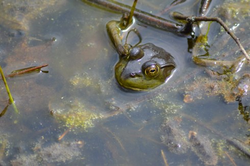
While there were signs of wildlife, I was only able to see some fish in the water and a bird.
While the lake is a gem itself, one of the hidden treasures is the poetry box located on a tree by the lake. If you weren’t looking for it you might just miss it. Just to the left of the boat launch, the box is attached to a tree.
Inside the box sits a binder with poems, stories and memories left behind by visitors. There are also a few pencils in the box for people to leave their thoughts and poems. Some of the poems dated back to 2012. It was not only nice to see this collection of art. It was also nice to see it has been preserved and no one has stolen or disturbed the poetry box.
Behind the tree is a table for people to sit and read the binder or write their own addition to the binder. The poems and other writings ranged from the comedic to the serious. Some were written by children. Others were written by older people. Sometimes you could not tell who wrote the poem or what age they were.
Whether you’re a fisherman or fisherwoman, a boater or a poet, Leverett Pond is the perfect to spend the day.
Parking: There are 15 total parking spots designated for the rail trail. There are 5 spots in the main parking lot on Friedenfels St at the entrance to the trail. There are also 10 parking spots across the street from the main parking lot. There is a larger parking lot in front of the main parking area that is a private lot. Don’t park there as your car could be towed.
Handicapped Accessible: Yes, the main trail is handicapped accessible. The side trails are not accessible due to the rocky trails and steep inclines. There is ramp to the right of the staircase to the trail at the parking area.
Dog Friendly: Yes
Highlights: scenic views, wide and easy trail, side trail, dog friendly, family friendly, benches to sit at, wildlife
Once the site of a grand railroad that ran from Boston to sections of Boston’s North Shore and New Hampshire, the Eastern Marsh Rail Trail is a true gem of the coastal section of the north shore (cities and towns north of Boston).
The railroad, which would be extended over time, began operating from Boston to Salem in 1838. It would later be extended to Salisbury and other territories in Massachusetts and New Hampshire in 1840.
Alas, the last train crossed the Merrimack River in 1965, leaving behind abandoned rail lines. Eventually, it was proposed that the rail lines should be converted to rail trails. Now, many decades later, instead of being used by noisy engines often carrying dangerous cargo, the rail lines are being used for exercise, dog walking and just enjoying nature.
The 1.4 mile Eastern Marsh Trail connects to the Clipper City Rail Trail to the south and the Ghost Trail to the north.
The Eastern Marsh Trail, which is part of a system of trails along the coastal north shore which includes Newburyport and Salisbury.
The trails at Eastern Marsh Trail are flat with no significant inclines.
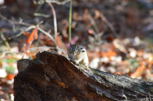
The Stevens Trail is a short trail (about .4 mile) that hooks up back to the main trail. There are some views and a cute bridge along the trail. You may see a few chipmunks along the way. It has some minor inclines but I would classify it as easy. This trail is not handicapped accessible due to the rocky terrain and a bridge that only has steps and no ramp.
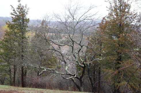
The views along the trail are beautiful.
There are still remnants from the original railroad at the beginning of the trail. Maybe some day they will revive the rail!
This mural from the Salisbury Art Stroll held on May 13 was still remaining along the trail. I just missed it by a week. But, I may have to drop by next year to check out the art on display. This mural was a collaborative effort worked on by a group of artists.
There were lots of little critters on and off the trail. I would hear rustling in the trees or bushes in one direction only to be distracted by some other sound of activity in another direction.
Birds
turtles
and chipmunks
are just a few of the animals you may see on the trail.
But, birds, chipmunks and turtles aren’t the only animals who frequent the trail.
The trail is a popular with dogs and their walkers.
I love the “side eye” Peter, a 14 year old Golden Retriever, was giving his human walker in the first photo. All he wanted to do was greet me and say hi.
I love how May’s white fur looked against the background. May is a 6 year old Golden Doodle.
Look at the big smiles on Mako (on the right) and Murphy (on the left)! Mako is 6.5 years old and Murphy is 7 years old. They are both Labradors.
Parking: There is a lot that accommodates about 50 cars next to the reservation. It fills up quickly on nice days. I got the very last spot when I went in the morning.
Dog Friendly: Yes
Handicapped Accessible: Yes
Highlights: rocks for climbers to practice on, easy, gentle trails, graffiti, family friendly, scenic views
Once the site for swimmers and divers, Quincy Quarry is now a haven for rock climbers, dogs and graffiti artists.
Quincy Quarries Reservation (or as we used to call it “The Quarries”) was originally built in 1825 as a large scale quarry industry, Over the years, however, it has gone through some dramatic changes.
Fun fact: stones from the quarry were used to as the main source of stone for the Bunker Hill monument in Charlestown.
The grassy fields and paves walkways used to be the site of a quarry industry. And water took up most off the area that is now grass and concrete. Business deals (a golf course is located just past where the quarry industries once stood) and a slew of deaths (mostly from diving into the water and some under more mysterious circumstances) at the quarry sparked the debate to fill in the quarries and use the land for business purposes. According to the New York Times, at least 19 people have died there (and who knows how many cars and other objects lied at the bottom of the water). In fact, a post or series of posts could be dedicated to the controversial and mysterious past of the area. So, the quarry was drained in most parts and the area was made into a walking park.
So, where did all the dirt come from to fill in the once watery quarry? Remember he “Big Dig”? Yup, that dirt was used to fill in the drained quarry. There is still some water in the quarry. But, people don’t jump in it anymore. Not only is it very dirty, it is seemingly much more shallow and there is much less of it.
After the last quarry closed in 1963, the area was dormant except for the people, mostly younger kids, who enjoyed diving off the precipitous rocks.
It’s hard to believe this area was mostly just granite and water a few decades ago.
Rocks, paths and grass cover what was once water.
Boy have times changed, The very same quarry that my father used to dive in have largely been filled in and paved over or have become fields. And, instead of jumping off the quarry, people climb up them.
This particular rock was 60 feet high and the path to the top was pretty narrow. But, I made it up.
The groups of climbers all work together to ensure their ascent is a safe one and cheers erupt from the other climbers whenever anyone makes it up.
You can learn a lot when you go on photo shoots. I’ll never complain about my physical obstacles again after watching this climber.
The climbing teams, and it is a team effort, go through great efforts to ensure each climb is safe. The people go over the procedures and safety protocols before each climb. Each person has a role whether it is the person holding onto the line, the device keeping the person suspended or the climber. Still, it’s hard to believe one rope or one board could be the difference between success and failure (although there are other backup safety measures as well). It is very safe if you take the correct measures, though.
Its a long way down.
The funny thing is I am not exactly fond of heights. But, whenever I have my camera with me I get so focused on what I am doing and I don’t really think of the risks as much as getting a good photo.
The views from the rocks are impressive, the skyline of Boston being the highlight of the various views. You can also check on the traffic into Boston from that rock before you leave.
There are several rocks at Quincy Quarry that people use to climb, draw on and just rest on.
The graffiti is one of the first things you will notice upon arriving at the Quincy Quarry Reservation. In fact, it seems to be encouraged.
There was also this creative and romantic proposal scrawled against one of the rocks.
There is also abundant wildlife at Quincy Quarry Reservation. Although they weren’t there (or they were hiding) during my visit, coyotes and deer are known to inhabit the area. I only came across a frog who thought he was hiding from me
a chipmunk
and various birds
I also saw lots of dogs at Quincy Quarry.
Baxter is a 2 year old Border Collie. He may have three legs. But, he is just as beautiful and sweet, if not more, as any other dog I saw that day.
Maddie is a 9 year old mixed shepherd. But, hey, how did she get up there!?
Here is a video from YouTube to give you a sense of how different the quarry looked and just how popular of a spot it was.
Location: Barney’s Joy Road, Dartmouth, MA (about 1.5 hours south of Boston and 45 minutes southeast of Providence, RI)
Hours: The park is generally open from Memorial Day to Labor Day. Park hours in season are 10 am to 6 pm weekdays and 8 am to 6 pm weekends and holidays. You can park at the entrance (a gate prevents access in the off season) and walk the roughly half a mile to the beach
Cost: $12 MA Vehicle, $14 non-MA Vehicle, see website for additional fees for boating
Parking: there is ample parking near the beach after you pay at the entrance.
Handicapped Accessible: Yes
Dog Friendly: Yes, but they are not allowed on the beach from April 1st to September 15th, unless they are service pets
Located along the southern coast of Massachusetts, Demarest Lloyd State Park has some of the prettiest views of any state park I have visited. Its abundant bird population, scenic views and sandbars make Demarest one of the truly special places to visit and get away from it all.
Demarest is a bird lovers paradise, especially during the off season when there are less people, cars and other disturbances to scare them away.
The views at Demarest are truly breath taking.
I kept thinking to myself, sometimes the world is indeed a very beautiful place. It’s important to have places like this treasure to observe and appreciate pure beauty. Demarest was easy to photograph. The hardest part was deciding which photos to post. All I had to do was check my settings and point and click. The beauty was already there, all courtesy of Mother Nature.
It was low tide during my visit. So, I was able to walk out onto some of the sandbars and get up close to some of the gulls at the park.
There were also several lobster pots and other cage-like devices that had washed up along the shore or were being stored there for safe keeping
If you do walk past the beach area, as I did, you should remember to pack or wear an extra pair of walking shoes (flip flops and sandals won’t be adequate) because the path turns from sand to pebbles and seashells. It is worth the walk, though.
One of the few creepy things at the park were these spiders. And they were everywhere. I must have seen dozens of them. So, if you do lie out there on a beach blanket, I’m just saying…but they have a purpose and place here as well.
What better way to celebrate Earth Day then a visit to Stavros Reserve in Essex, MA?
It was a windy and raw day, more like a fall or winter day than a spring day. But, such is the weather for New England. I just considered myself lucky that it wasn’t snowing. This is New England after all.
Stavros Reserve is easy enough to find. Parking, however, is a different story. After driving past the reserve in the hopes of finding a parking area, I turned around and settled on a parking spot on the grass by the side of the road. Several cars (5-10) could probably squeeze in this parking area before the side of the road narrows to accommodate the traffic on Island Rd.
At first glance, Stavros Reserve doesn’t seem like much. The moderately steep roughly quarter of a mile incline features some scenic views, pretty trees
and this creepy looking tree that reminded me of the trees from the Wizard Of Oz.
Once you reach the end of the trail, you’ll see a stone structure that was once a fieldstone base of a 50-foot, three-level tower built by Lamont G. Burnham in the 1880s.
The top of the trail at the reservation has some eye catching views.
Inscribed on the marker under the tree is:
“This land is a memorial to
James Niclis Stavros
For the enjoyment of all who find
Renewal of spirit in nature
Mary F. Stavros
May 17, 1986”
As an aside, I fell in love with Essex while I was there. Antique shops and well manicured colonial style homes line the main streets. It’s an old New England town, incorporated as a town in Massachusetts in 1819, that has kept its charm.
The birds, seagulls specifically, were acting strangely while I was there.
That was enough for me. I saw a flock of seagulls. So I ran. (only people over 40 might get that one)
Please connect with me on Facebook to receive alerts whenever I post and to view other content I do not post on this blog. Thank you!
Location: Seapowet Ave, Tiverton, RI (about an hour south of Boston and about 30 minutes southeast of Providence, RI)
Cost: Free but donations are appreciated
Hours: Trails are open dawn until dusk
Parking: There is a lot which can accomodate about 5-10 cars
Trail Difficulty/Size: 50 acres of easy but narrow trails, I couldn’t find a description of the trail lengths but it can’t be more than 4 or 5 miles total
Handicapped Accessible: No
Dog Friendly: No, Audubon sanctuaries are not pet friendly
Highlights:easy trails, blinds to hide behind bird watch, wildlife, streams and bodies of water, birds, scenic
As a preface, I am trying to post about as many of my trips from earlier this year before the end of the year. So, I may be posting pretty much every day until the new year and into the beginning of the new year to catch up and start fresh in 2017. Lucky you… ( :
Tucked away just over the Massachusetts and Rhode Island border is a serene little trail with lots of surprises.
One of the cutest surprises are these blinds that you can hide behind to photograph or observe birds.
The trails at Emilie Ruecker are easy enough to navigate and they are mostly loops so it is easy to stay on the trail. There are also maps displayed throughout the sanctuary. The trails can be narrow in some areas. Also, if you go on the red trails, it’s easy to go off track. Just keep looking for the color coded trees to stay on track.
One of the cool things are the openings along the trails that allow you to get closer to the water so you can view the ducks and other birds.
You’ll also find the occasional bench to rest at.
Although there is lots of wildlife at the sanctuary, the highlight for me was the beautiful scenic views.
If you look closely, you may see the outline of a deer just behind the branch of this tree. Unfortunately, my camera couldn’t focus in time to get a better photo.
Much like this deer, the birds at Emilie Ruecker were hard to photograph.
The birds in the water proved more easy to photograph.
These birds were very easy to photograph, as long as I kept my distance. They were hanging out on the other side of the road across from the sanctuary on some farm land.
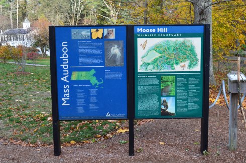
Moose Hill Wildlife Sanctuary in Sharon, MA, may not have moose but it has everything else that makes a sanctuary the perfect place for a weekend hike. Pretty flowers and trees, scenic views and wildlife are plentiful at Moose Hill.
The nature center at Moose Hill was decorated for the autumn season with pumpkins and a quilted figure.
The trails at Moose Hill are, for the most part, easy with some modest inclines, except for the trail up to the fire tower. There is also a boardwalk over a red swamp area and some other boardwalks that are a nice touch.
The trail to the fire tower is challenging but it’s not too difficult. It’s a short incline up to the tower. Unfortunately, it appears to be off limits. Usually, signs and barriers don’t stop me but I draw the line at barbed wire. It’s too bad because the views must be amazing.
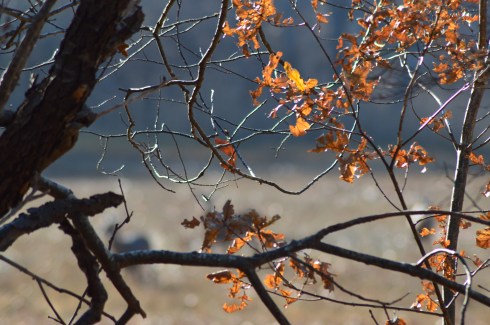
Instead of the fire tower, there is a great overlook at the Bluff Overlook on, oddly enough, the Bluff Trail. Most of the trees have shed their leaves but yyou could still see some pretty colors out there. I especially liked the branches in the first photoon the left hand side of the group of photos.
It is easy to find beautiful areas to photograph in Moose Hill all year round. Ideally, foliage season would probably be the best time to visit. I just missed the peak foliage season but it still looked beautiful. The shapes of the trees and the way the rocks form borders in the different sections of the park make for great photo opportunities. It really doesn’t take a lot of effort or talent to find the beauty of the sanctuary.
There is also a beekeeping harvest hive and a real hive located near the harvest hive. Both looked inactive. A bench sat precariously near the now destrcuted hive. “Be At Peace” is engraved on the backing of the bench. Good advice.
I was a little disappointed by the lack of visible wildlife during my visit. I got there early (between 7 and 7:30) but I still didn’t see any of the larger wildlife that is known to be there such as deer, foxes and coyotes. I did see these little critters, though.
chipmunk, Moose Hill Wildlife Sanctuary, 11-13-16
red squirrel, Moose Hill Wildlife Sanctuary, 11-13-16
And this owl.
Fooled ya!
But, this owl is an actual part of the sanctuary. It’s part of the “unnatural trail.” The unnatural trail is a family friendly trail that is geared more for children. The trail is about a quarter of a mile that has objects that you normally don’t find on a trail (like shovels and shoes for instance). The children are then asked to identify the randomly placed objects and answer questions about what was on the ttrail.
There is also the Billings Barn (the white building) and a maple sugar shack which campers use to make sugar from the sugar maple trees. During maple sugar harves season, the campers and people at the sanctuary leave buckets attached to the trees to harvest the maple sugar from the trees.
Highlights: biking and walking trail, flowers, scenic views, stones with words and phrases of encouragement on them
The G.R.A.C.E. Trail in Plymouth, MA, is not your average walking or biking trail. Standing for Gratitude, Release, Acceptance, Challenge and Embrace, the idea for this trail is the creation of author, life coach and TED X speaker and Plymouth, MA, resident Anne Jolles. The trail is designed to help people reflect on and overcome their struggles. According to Ann Jolles’ website, the trail is meant to get people from, “a state of confusion and overwhelm to one of hope and possibility.” Now, inspired by Jolle’s trail, GRACE trails are appearing all over the country.
There may be many grace trails but this one in Plymouth, MA, is where it all started.
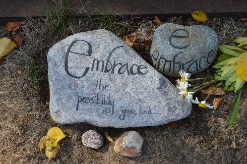
Located next to Nelson Memorial Park, GRACE trail appears like any other trail. However, upon closer inspection, it is very different. Rocks and stones with words of encourage and placed along the side of the trail. At the entrance of the trail, there are rocks with words of encouragement (these rocks have gratitude and “just breath” written on them) and a notepad to write your own words of encouragement. The person who left a message on the notepad about how he or she left someone who was abusive and “free” is written underneath the message. It’s very inspiring and for the cynics out there who think that may have been a “faked” message (I know you may be out there), who cares? It’s something people could still draw inspiration and maybe a nudge to do the same thing. And that is what this trail is all about; inspiring others and grace.
Along the trail, you’ll find other signs of inspiration and grace.
I love how one of the rocks says to “accept…or not.” You don’t have to and should not accept certain things in your life.
These rocks encourage you to embrace the possibilities and “hang on” to hope.
There are messages of hope and inspiration everywhere
I know I could really use a place like this with all of its positivity and inspiration. I would go everyday if I lived closer to the trail.
The trail are very easy and level along at Grace Trail.
In addition to the pretty stones and encouraging words, there are scenic views and trails that go off into other areas like the trail below that leads to the beach. The views are very pretty along the trail.
The beach offers views of Plymouth Harbor and the surrounding area.
Since it was such an unseasonably warm autumnn day, there were an assortment of boats (motor powered and otherwise) in the water.
There is also remnants of a railroad that used to go by the area. Flowers and grass now grow where the train used to run.
The Grace Trail is also dog friendly. Lilly, a 9 year old Palmarin, enjoyed walking along the trail.
Parking: There is a designated parking area with about 30 to 40 parking spots. There are also additional parking spots on the other side of the main parking area on the side of the road as you exit the main parking area
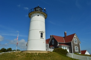
Highlights: lighthouse, scenic, views of the ocean, bird life
Lowlights: Parking can be difficult since it is such a popular spot (there was a line of cars waiting to park when I left and that was on a rainy day)
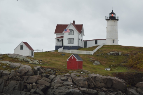
Also known as Nubble Light, Cape Neddick Lighthouse is an 41 foot (88 feet above sea level) cylindrical lighthouse on the edge of Cape Neddick, a community in York, Maine.
The lighthouse is actually on Nubble Island, hence the name Nubble Light. People like to call it Nubble and it sounds like a cuter name. So, yeah, I’ll go with that.
Originally constructed in 1879 for $15,000 (roughly $342,000.00 in today’s money), Nubble Light is located about 100 yards off Cape Neddick Point. The light was automated in 1986.
Nubble Light is one of the easiest lighthouses to photograph. From Cape Neddick, you have wonderful views of the lighthouse.
There is also a rocky area you can climb down to get closer to the water and get some sweet views of the lighthouse. Uhm, yes.
As you can see in some of the photos, it was a very windy day and the waves were crashing pretty hard against the rocks. Between the rain and the water from the surf it was almost impossible to keep a dry lens, although I tried.
Since people feed them, birds seem to flock by the area.
The weather conditions didn’t deter this hardy Maine fisherman. He did catch and release.
As you leave the parking area on the other side of the lighthouse, there are some pretty views.
Cape Neddick is a dog friendly area. Logan, a 2 year old Red Hound and Coon Hound mix, likes to look out at the lighthouse also.
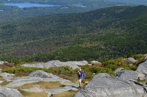
Standing at 3,165 feet, Mount Monadnock is considered one of New Hampshire’s “easier” climbs (according to alltrails.com). But, before you lace up your hiking boots and pack up your car for the scenic drive to the majestic mountain in Jaffrey, New Hampshire, you may want to get a second opinion.
While it isn’t the hardest climb you will make, it also isn’t an easy climb, particularly for beginner climbers. I saw more than a few climbers taking breaks on the side of the trail to the top. But, it is worth all the hard work and time to get to the top when you see the views.
At the beginning of the trail, there is a reminder to not make or knock down the cairns on the trail.
The dirt trail at Monadnock starts off easy enough as a straight trail with a slight incline. From there, the trail gets tougher. The inclines become more drastic and the terrain turn rocky.
There are some pretty views on the way to the top. About three quarters of the way to the top of Mount Monadnock, there is an area to sit or stand and take in the views of the surrounding area. On a clear day, you can see the Boston skyline. You may be able to see it in some of these photos.
The trail gets slighly easier after the first 3/4 of the trail. But only slightly. Keep in mind this was my first hike up any mountain. So, it may be much easier for an experienced climber. In any case, there are several areas to take photos as you inch closer to the top.
Finally, I made it to the top. It took me about 2 to 2.5 hours to get to the top. Bear in mind I had a camera with me that I had to make sure I didn’t hit against a rock (I always keep the camera by my side and not in my backpack or carrying case because you never know when you might need to take a photo at a moments notice) and again it was my first time hiking anything this size. So, an experienced hiker without a camera would probably be able to complete the ascent in about an hour.
The views from the top are breath taking. Be sure to take a sweater with you, even if it is a warm day when you go, because the winds at the top of the mountain are very strong.
I had enough trouble hiking up to the top by myself, never mind doing it with someone strapped to my back like this guy!
Due to the geoloical makeup of Mount Monadnock, there are some little ponds of water and colorful grass at the top.
Keep in mind, Monadnock is a very popular attraction and the trail does get busy quickly, especially during ideal hiking days.
If you’re lucky, you may run into Larry Davis. Larry has been hiking Monadnock virtually everyday (rain, snow or shine). he has easily logged in thousands, probably tens of thousands, of hikes up and down Mount Monadnock. He also takes some beautiful photos from Monadnock on a camera with film. He was nice enough to pose for a few photos for me.
I found some other cool things on the trail. There is a flying insect of some kind that makes a clicking sound while it flies, signs of fall and some interesting rocks with names etched into them. The names etched into the rocks are the names of the families that lived at the bottom of the mountain or the surrounding areas and some are said to still live there today.
Mount Monadnock also has comfort stations and a general store at the base of the hill so you can refill the calories you will surely burn hiking.
In short, Mount Monadnock is the perfect hike for beginners and experienced hikers. Hopefully, I’ll see you up there soon!
Below are some videos from my hike at Mount Monadnock. You can hear the wind blowing in some of the videos.