Date Of Visit: June 4, 2017
Location: The Mount, 2 Plunkett St, Lenox, MA
Dates and Hours of Exhibit: June, 2017 – October, 31, 2017, The Mount is open daily from 10:00 am to 5:00 pm through October 31st, except on early closing days (please see below). The Mount is open from 10:30 am – 3:00 pm most weekends in November through February. Please call 413-551-5100 to confirm hours.
Cost: $18 for adults, $17 for seniors (65 and older), $13 for students, children and teens (18 and under) get in free, $10 for military personnel (cost includes a tour of the Edith Wharton house and if you return within 10 days you can get in free again with your receipt)
Parking: There is ample parking available at The Mount.
Handicapped Accessible: Yes. The trail is dirt bit wide and even for the most part.
Dog Friendly: No, except for service dogs possibly
Highlights: art on a easy trail, scenic views
Website: SculptureNow
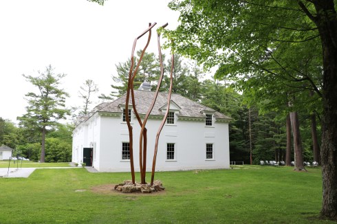
As if the Mount wasn’t beautiful enough, there are 30 amazing sculptures to compliment its beauty.
There are 30 sculptures along the trail. But, when I went to visit in early June, not all of the sculptures were up. I did the best I could to photograph as many as I could find. But, I didn’t have a map or any other guide at the time to find them. So, it was something like a “scavenger hunt” when I did visit the sculptures. It looks like I found 22 of the 30 sculptures. The art has a modern feel to it. All thirty sculptures should be up now for your viewing pleasures.
The numbers next to the descriptions correspond to the descriptions in the map of the trail where the sculptures are located. The link to the trail map is attached above in the website link.
1. The first sculpture is called Stall by Nancy Winship Milliken. Nancy describes her sculpture as the following:
“This site-specific memorial honors the activities and architecture of a New England past. The horsehair gestures towards the building at The Mount which was at one time Wharton’s stable.”
2. The second sculpture is called Day’s End by James Kitchen. James says his sculpture this way:
“Does our fast-paced, distraction filled world allow time to think, read and reflect, enjoy art in all its forms? Exhausted, we let media affirm our feelings rather than inform us.”
3. The third sculpture is by Harold Grinspoon. According to Grinspoon, his art is:
“Giving new meaning to objects that have aged out of their original purpose, I invoke nostalgia for the familiar and an appreciation of new forms of beauty.”
4. 3. “Fallen Sky” by Coral Penelope Lambert is the next sculpture. Coral explains her art this way:
“My work explores forces of nature and seeks to address the darker issues related to Earth’s resources such as mining and contamination where traces of the process remain.”
5. Stack C by Lydia Musco is a combination of nature and architecture:
“Architecture and elements of nature, such the work of gravity, influence this work. The form is built in one additive action, line by line, like layers of stories within memories.”
6. James N Burnes’ sculpture Nine Piece Ring is the next sculpture. Burnes described his art this way:
“I create forms from nature that express our intimate relationship with Mother Earth. I am drawn to the tension between the natural and organic, man and nature, time and decay.”
7. Biomorphic by Michael Thomas is the next sculpture. According to Michael, Biomorphic is:
“An undulating, sensual, and playful organic form, often encountered on the periphery of the natural world, realized here in steel. Biomorphic is the fluid movement of mass, coupled together with the visceral experience of color and texture.”
8. Distant by Philip Marshall is, according to Marshall:
“The nude model at a figure drawing held his pose for hours, eyes fixed on a distant point, maintaining his mental distance under prolonged scrutiny; he and the chair becoming one.”
9. Off The Rails by Lucy Hodgson:
“Our country: how we got here and is there a way forward? This is a comment on the decline of infrastructure—among many other things.”
10. Sheep by Madeleine Lord is:
“A pile of galvanized scrap metal sheering implied the subject: Steel Wool. I work the skeletal to the surface and the surface to the skeletal. Pulse arrives after I finish.”
11. Joseph Carpineto’s Walkabout
“This sculpture is inspired by a memory of the coarse undershirts my mother made for me from flour sacks. The rough feel of the rope is reminiscent of those undershirts.”
12. Bench I by Peter Barrett:
“Please, have a seat! I’ve wanted to incorporate some stone into my work since visiting a friend’s marble quarry, and here you have my first attempt.”
13. Anabasis by Chris Plaisted:
“I like to work with steel for its strength and powerful emotion. The subject is the human spirit. I was inspired by the sea and the concept of an upward journey.”
14. Yellow Peril by Setsuko Winchester:
“In 2015 & 2016, these 120 handpinched tea bowls traveled to ten U.S. concentration camps where 120,000 persons (mostly U.S. citizens) were imprisoned during WWII. Their crime was to be Japanese.”
15. Reflective Change by Martina Angela Muller:
“The undulating lines of music and the sculptural force of the wind informed these shapes. Both are continuous game changers that generate inner and outer movement leading to reflective change.
16. Avoidance Attractor by Matt Crane:
“Avoidance Attractor in its first iteration explores structure and materiality with a shift in scale and orientation. An empty piece of signage that invites projection, while remaining stoic and silent.”
17. Netting For Water by Ann Jon:
“My work is an adventure, exploring new forms and media, hoping the viewer’s eye, mind, and heart will experience the sculpture visually, creating their own narrative or message.”
18. Fenestral by William Carlson:
“This sculpture is intended to pull the audience into the small portals of light as the sun rises and sets. The piece acts like a clock while controlling the viewer’s perception of the landscape.”
19. Blue Pulse by Murray Dewart:
“I want my sculptures to convey both the momentum of ritual pilgrimage and the stasis of meditative mandalas. They gesture in their various ways as resolute guardian forms, protective and consoling.”
20. Gnomon 1 by Christopher Curtis:
“Much of my work seeks context for humankind’s place in the natural world. Gnomon 1, made with stone, stainless steel, and gold leaf, is a good example of this investigation.”
21. Waterstone by Dove Bradshaw:
“Waterstone is a time-sculpture: For a slow action of water boring a hole, limestone was used; for fast boring, salt boulders and granulated salt mounds. Outdoors in winter, vodka replaced water.”
22. Poet’s Cry by Colleen O’Donnell:
“Weepings of unsound. A poet’s cry of light. Reflecting back into herself.”
23. Bittern by Robin Tost:
“The Bittern is a marsh bird who, when alarmed, stretches up its neck so that the striations on its breast give it perfect camouflage in the reeds.”
24. Twelve Cuboid Stack, I by David Teeple:
“My work centers on water as a subject, a material, and an idea. In this sculpture, I am interested in how the reflections and refractions create a new perceptual experience.”
25. Yellow Dakota + River by Stuart Farmery:
“Through abstract forms I reference a passage of time combining art historical sources, such as stone circles and constructivist concepts, with my awareness of current political, environmental, and communal issues
26. Hedge by Gary Orlinsky:
“Inspired by the two rows of linden trees that link the Mount’s gardens, Hedge creates a provocative dialogue between the organic movement of the saplings and the geometry of the boxes

27. Gilavar by William Brayton:
“This abstract sculpture developed in response to a range of sources, including indigenous wind patterns, Polynesian stick charts, wooden boat building methods, storm tracking data, and chance-based fabrication systems.”
28. Gene by Eric Stein:
“Representing cause and effect, the cast concrete units of molecular design are stacked, colliding randomly. They present an undetermined beginning and illustrate the natural selection of options of creativity, form, and life
29. Tree With Spheres Jacque Metheny
“My sculpture juxtaposes geodesic spheres with the yet more complex structure of a tree. Geometric systems are the foundation of all material form. In nature we understand this as beauty.”
30. Caterpillar Bridge II by Roe Osborn:
“My sculpture combines construction materials in contextual mathematical formulas. This piece joins sections of drainage pipe in a dimensional sequence that captures and defines space in an engaging, yet playful manner.


 Thousands of people converged on the Charles River last weekend to celebrate the 38th annual Dragon boats festival. Over 30 teams raced 39 foot Hong Kong along a 500 meter course (CYPN Storm won the Club Challenge, “A” Division).


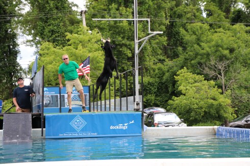 Dogs big and small came from all over New England and farther to take part in the Dock Dogs competition last week in Agawam, MA.